

Brandywine Falls Hiking Guide
Incredible sights surround the Sea to Sky Highway. Stops along the drive from Vancouver to Whistler, BC, bring you to mountain vistas, peaceful lakes, and sunsets over the Howe Sound. Even in this place of marvels, Brandywine Falls stands out. The roaring waterfall makes a dramatic single plunge into a deep recessed canyon, the legacy of glaciers and volcanoes. If you have a packed road trip itinerary, seeing Brandywine Falls can be a quick 20-minute visit. Longer hiking and biking trails make the park a good standalone day trip, one that could include bungee jumping. Here’s everything you need to know about visiting Brandywine Falls Park.

Lake in Brandywine Falls Park
Know before you go
It’s free to visit Brandywine Falls Provincial Park.
The park gate is open from May through October. Don’t park by the gate in the winter. You might get towed.
The parking lot sometimes fills up, and you may have to wait for a spot. I visited on a Saturday in August and had no trouble parking at 10 AM. When I left a little after noon, it was almost full.
Restrooms and picnic tables are by the parking lot.
Leashed dogs are welcome in Brandywine Falls Park.
The viewpoints are fenced and family-friendly.
You’ll see pictures online of the bottom of Brandywine Falls with directions on how to get there. Ignore them. It’s illegal and unsafe. You’ll still get great views on the official trail.
The crushed gravel trail to Brandywine Falls is wide and flat with an even surface. It doesn’t have barriers like steps. It’s doable with a stroller and many mobility devices. Beyond the waterfall viewpoints, the terrain is more variable.

The Brandywine Falls Viewpoint is fenced and accessible
Hiking options
Brandywine Falls is the main event. This 1-km hike has the easiest terrain and the biggest reward. Most people turn around after seeing the waterfall and the Daisy Lake viewpoints.
Swim Lake is a short side trip on the way to Brandywine Falls that ends at a secluded lake. It’s only a 0.3-km detour from the waterfall hike, but the trail is rougher.
Whistler Bungee Bridge is a satisfying destination if you’re interested in exploring more of the park. It’s about 6 km total, including a stop at Brandywine Falls. If you just want to get to the bungee jump, you can also drive there instead.
If you take the trail heading away from Brandywine Falls, you’ll pass a few marshy lakes, including Lava Lake. I’d call this direction the lowest priority unless you’re looking for a longer hike. There’s the potential to combine the highlights on a 10-km loop hike if you don’t mind walking on the road for a decent portion of it.
Check out the park map for a detailed visual of the trails.
Brandywine Falls
Distance: 1 km (0.6 miles) out and back
Elevation gain: 45 m (150 feet)
Difficulty: Easy
From the parking lot, take the covered footbridge over Brandywine Creek to reach the hiking trails.

Cross here
On the other side of the bridge, a sign points toward potential destinations. Take a right to head toward Brandywine Falls.

Take a right
The trail to the waterfall is a flat and easy stroll that follows Brandywine Creek through a forest of Doug fir, cedar, hemlock, maple, and ash. In late summer, I spotted some salal berries and huckleberries on the bushes in the undergrowth. This part of the hike is the busiest, but the trail is well-maintained and wide enough to accommodate the heavy traffic.

Trail to Brandywine Falls
Around the halfway point, you’ll pass a trail junction with a sign. The trail to the left leads to Swim Lake, which can be a fun detour before or after seeing Brandywine Falls. We’ll keep right to head toward the waterfall. Just past the sign, you’ll cross railroad tracks. It’s active, so keep an eye out for trains.

Cross here
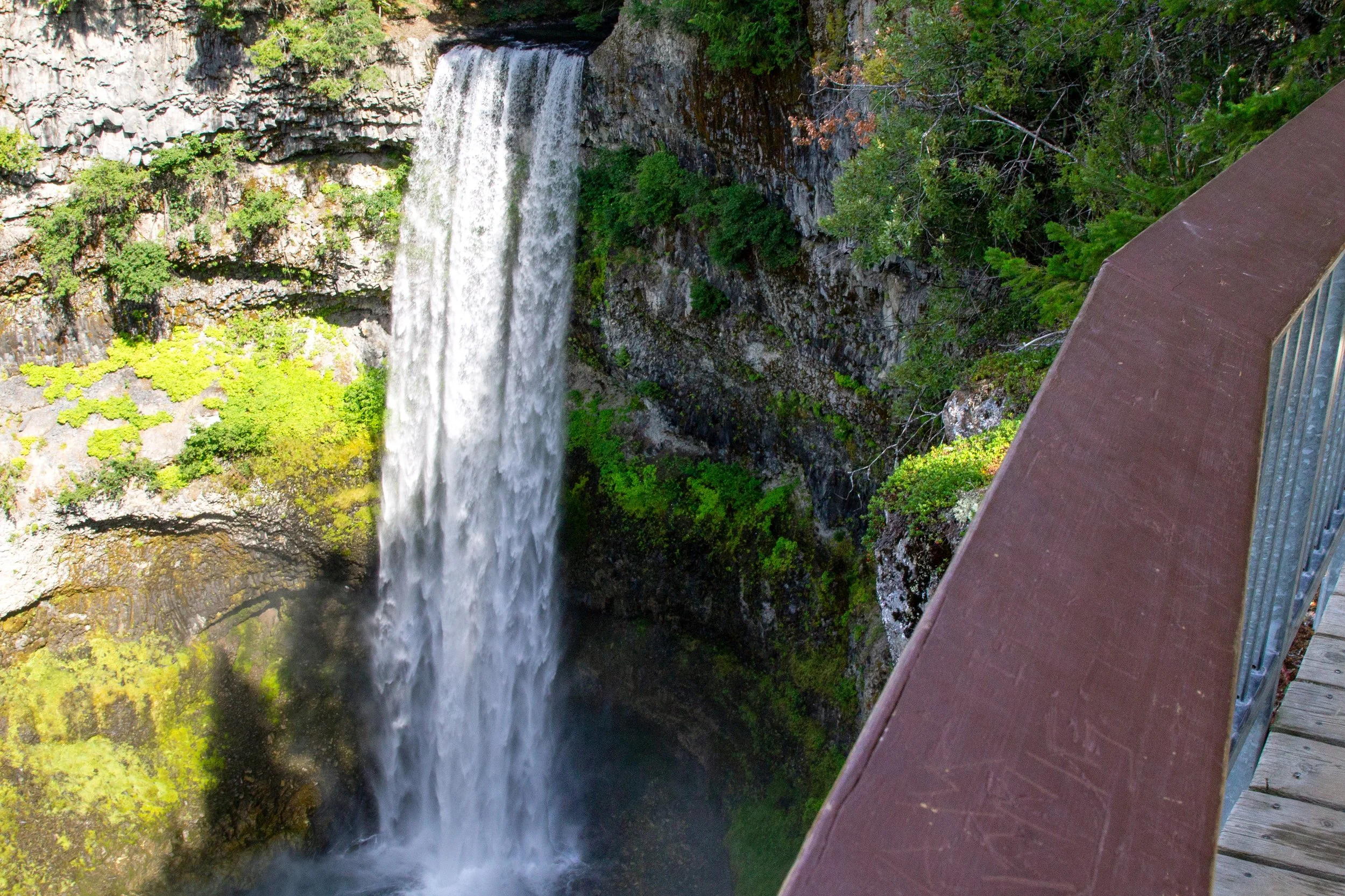
On the other side of the railroad tracks, the Sea to Sky Trail splits off to the left. Keep going straight toward Brandywine Falls. The first viewpoint is just past the junction. From the fenced platform, you’ll have an excellent view of the 70-meter (200-foot) waterfall making a powerful single plunge over a lip of basalt. Softer rock sits under basalt layers in the canyon surrounding Brandywine Falls. As these softer layers erode, they undercut the basalt layers, making them prone to collapse and widening the canyon over time.
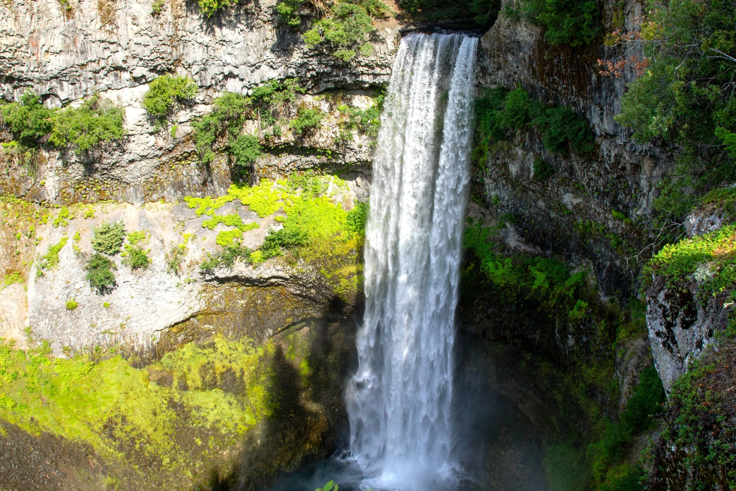
Brandywine Falls
The trail continues for a short distance past Brandywine Falls. You’ll pass a second, less impressive waterfall viewpoint that’s partially obscured by tree cover. Continue past it another 50 meters or so to reach the final viewpoint, a sweeping panorama overlooking Brandywine Creek as it flows through the forest out to Daisy Lake, remarkable for its robin’s egg blue.

Daisy Lake Viewpoint
After the Daisy Lake Viewpoint, almost everyone heads straight back to the car. You’ve seen the best highlights at this point. It could make sense to end things here, especially if you’re planning to make more stops on the Sea to Sky Highway. To see more of Brandywine Falls Park, you can make a short detour to Swim Lake, or a longer one to the bungee bridge.
Swim Lake
Distance: 1 km (0.6 miles) out and back
Elevation gain: 30 m (100 feet)
Difficulty: Moderate
Swim Lake can be a short and easy detour on the way back from Brandywine Falls. It doesn’t have the grandeur and wow factor of the waterfall, so I’d only tackle this one if you’re in the mood to explore. From Brandywine Falls, head back across the railroad tracks and take the trail to the right. A sign will point to the Swim Lake Trail.

Follow the arrow to Swim Lake
Unlike the trail to Brandywine Falls, the Swim Lake Trail is narrow and rocky. It’s also almost deserted. On a crowded Saturday, my friends and I passed only one other group of hikers. Toward the end, you’ll reach an unmarked junction. Keep left. Swim Lake is just ahead. Despite the name, I thought the lake looked a little cold and murky. Not very tempting for swimming, in other words. I’d suggest taking a break by the water to look for frogs and birds, then heading back the way you came.

Swim Lake
Whistler Bungee Bridge
Distance: 6 km (3.7 miles) out and back
Elevation gain: 170 m (550 feet)
Difficulty: Easy
The Whistler Bungee Bridge is a great day hike on the Sea to Sky Trail. The full 100-km trail connects Squamish to Pemberton, BC. This approachable section of it in Brandywine Falls Park ends at a cool bridge over the Cheakamus River that people use for bungee jumping. From Brandywine Falls, start heading back and take the trail to the right just before you cross back over the railroad tracks.

Viewpoint on the Sea to Sky Trail
Unlike the Swim Lake Trail, the crushed gravel path stays easy without rough terrain or steep inclines. It’s a shared-use trail, so watch for mountain bikers. As you weave through the forest, you’ll reach a couple of excellent viewpoints overlooking the mountains around Brandywine Falls Park.

Sea to Sky Trail
When you’re close to the bridge, you’ll pass a few marshy ponds. The one across from the bungee bridge has a picnic table that’s perfect for a snack break.

Pond on the way to the Bungee Bridge
A viewpoint just before the bridge is a great place to watch bungee jumpers leap from 50 meters above the Cheakamus River. Sheer canyon walls surround the roaring river. Fine-grained silt ground down by glaciers turns the water a striking pearly blue. To the south, Black Tusk’s peak stands above the conifer-covered hills.
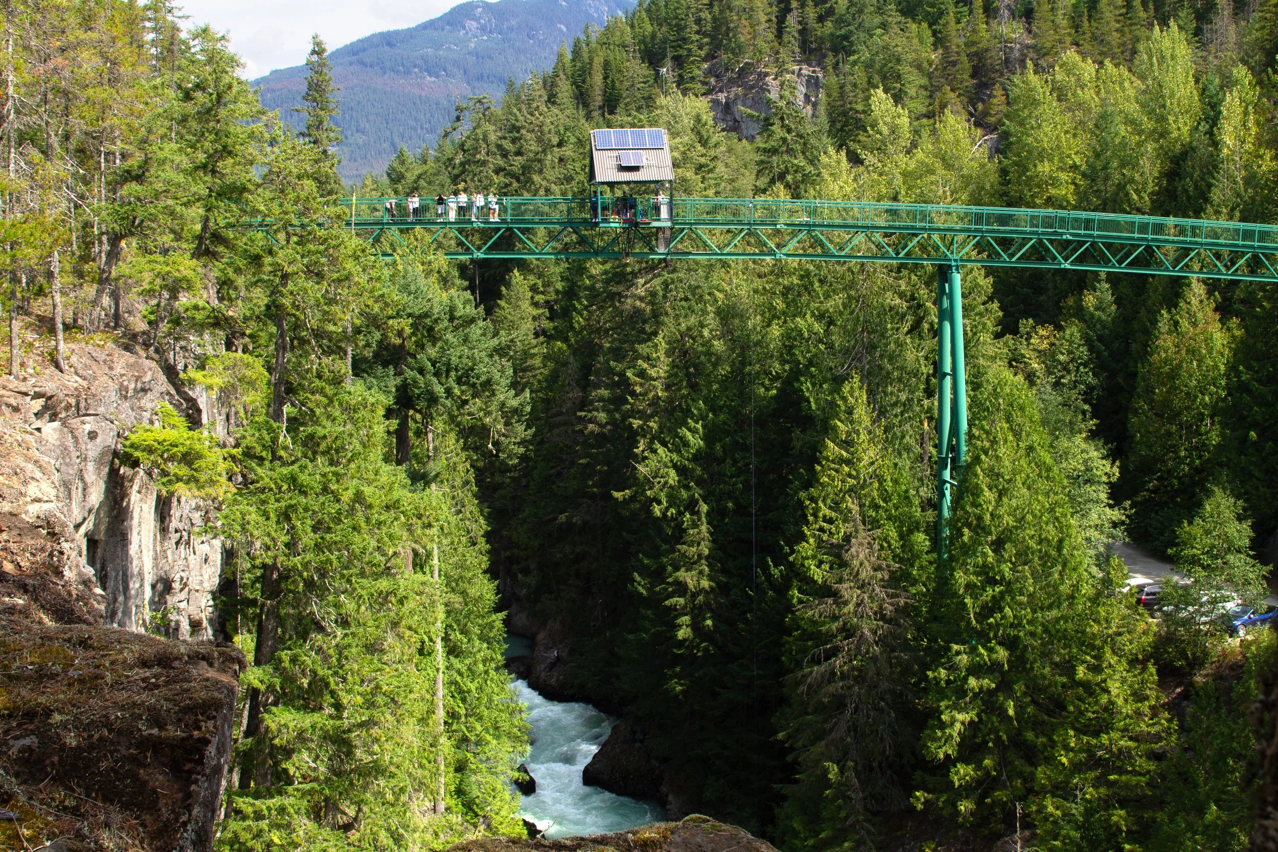
Whistler Bungee Bridge
From here, you can cross the bridge to admire the river canyon from above. If you want to try out the bungee jump, there’s a counter next to the bridge where you can sign up. Can’t say I was tempted, but the people doing it seemed like they had a great time. The Sea to Sky Trail continues on the other side of the river and leaves Brandywine Falls Park. The bridge is a good turnaround point for an easy day hike.
Getting there
Brandywine Falls Provincial Park is directly off the Sea to Sky Highway, BC-99. If you’re driving north from Vancouver, BC, look for the turn on your right. The drive takes about 90 minutes. If you’re driving south from Whistler, look for a left turn after about 15 minutes.
Enjoy your trip to Brandywine Falls Park!
With love,
Emma
Explore nearby

Find all the best stops on the Sea to Sky Highway.

Ride the Peak 2 Peak Gondola in Whistler.

Spend an incredible three days in Vancouver.