

Labyrinth Trail to Coyote Wall Loop Hike


The network of trails at Coyote Wall is one of the best in the Columbia Gorge for big sweeping vistas. On clear days, Mount Hood’s summit looms over Oregon’s cliffs. The Columbia River is rarely out of sight. Spring brings a bonanza of wildflowers to the grassy slopes. It’s a great destination early in the season, with the first blooms around March. Multiple trails make it easy to choose your distance and intensity. I’ll talk about Labyrinth Trail to Coyote Wall Loop, which connects the highlights in a rewarding day hike. Enjoy!

The trails at Coyote Wall have fantastic Columbia River views
Know before you go
It’s free to park at the Coyote Wall Trailhead. You don’t need a pass.
This hike is popular and the parking lot fills up. Arrive early on weekends in spring and summer. If the lot is full, try the parking lot on the east side of Coyote Wall (also free).
Restrooms are at the Coyote Wall Trailhead parking lot.
Dogs are welcome on the trails. They must be on a leash from December 1st to June 30th. They can be off leash other months.
The trails are shared between hikers and mountain bikers.
Watch for rattlesnakes. I saw two on my last hike.
There’s a ton of poison oak along the trails. Wear long pants and closed-toed shoes. Check for ticks after your hike.
The trails around Coyote Wall have little shade and can be very windy. Bring layers.
Other than the rattlesnakes, ticks, and poison oak, the hike is pretty family-friendly. I’ve sold it, right? The only drop-offs are on the Coyote Wall Trail and they’re easy to avoid.
Wildflowers bloom starting around March until early summer. Peak bloom is around the end of April. If you’re looking for thick balsamroot and lupine displays, this hike only has a small area at the top of the Coyote Wall Trail. Less showy wildflower species bloom everywhere. Please stay on the trails and don’t pick the flowers.
Have an offline map with you. The network of trails here is confusing.

Expect great views of Mount Hood on clear days
The Labyrinth - Coyote Wall Loop hike
Distance: 6.5-mile loop
Elevation gain: 1,500 feet
Difficulty: Moderate
Pass required: None
Dog friendly: Yes, leashed dogs are welcome on the trail all year. They can be off-leash from July through November.
ADA access: No
Season: Any
The details
From the Coyote Wall Trailhead, follow the paved road along the cliff. It was once Highway 8. It’ll be obvious why it’s no longer open to cars as soon as you reach the boulders.
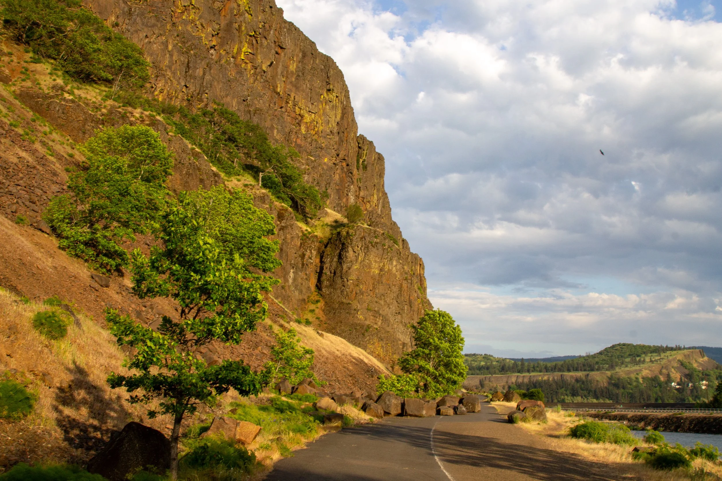
Start here
To the right of the trail is Locke Lake where I saw Canadian geese swimming with their goslings. Beyond the lake, you’ll see the Columbia River and the cliffs of Oregon. Desert parsley starts blooming along the trail and in the crevices of Coyote Wall in early spring. It had faded by May when buckwheat, yarrow, and bachelor buttons were out.

Locke Lake
Two trailheads about a quarter mile apart start from the paved road. You can take either to reach the Labyrinth Trail. The second one is the Labyrinth Trailhead, the most straightforward route. If you take the first one, you’ll hike about 0.1 miles on the Little Maui Trail, then take the connector trail to meet the Labyrinth Trail.

The first trailhead
If you walk a little past both trailheads, you’ll run into Lower Labyrinth Falls, which I’d say is worth the short detour.

Lower Labyrinth Falls
Once you’re on the Labyrinth Trail, you begin a long steady uphill climb. Look for grass widows, shooting stars, desert parsley, and cluster lilies in early spring. By May, yarrow, ookow, popcorn flower, fiddleneck, and coastal manroot were blooming. Some wildflower hikes have a narrow window to see the best blooms. The trails around Coyote Wall don’t have the big carpets of balsamroot and lupines like, say, Mosier Plateau or Memaloose Hills. To me, the timing is less important here. The views are as much of a draw as the flowers.

Desert parsley blooms early on the Labyrinth Trail
The Labyrinth Trail passes an intriguing little cave. You’ll walk next to Labyrinth Creek, which has a few small waterfalls on its course.

The cave
As you climb, the views of the Columbia River return. From here, you’ll have it in sight for most of the hike. I probably had about 50 photos of the river by the end of the loop. I’ve spared you all but a few.

Cluster lilies bloom by Columbia River views
The area around Coyote Wall has many strange and wonderful rock formations. Around 15 million years ago, lava flows traveled hundreds of miles from the east and deposited a thick layer of basalt. As it cooled, it formed tall hexagonal columns. The Labyrinth Trail has the most impressive columns around the Coyote Wall. The best of them make up the tower called Accordion Rock, a popular climbing spot.

Accordion Rock
Just past Accordion Rock is a lovely thicket where lupines grow under the oaks.

Lupines in early May
Not long after Accordion Rock, you’ll pass a little spur trail that leads to a viewpoint. If you’re looking for a turnaround point or a place for a scenic snack break, it’s a good option. You’ll get a great view of the Columbia River and the basalt formations you passed. Otherwise, keep going. The views are at least as good on the main trail.

Columbia River from the viewpoint
When you reach an unmarked trail junction, keep left. You’re now on Upper Labyrinth Trail. The addition of “upper” to the trail name is a nice morale boost after all the uphill walking. Plenty more where that came from.

Keep left here
You’ll start getting good views of Mount Hood’s summit as you trek up the Upper Labyrinth Trail. When you reach the next junction, take a left onto Atwood Road.

Follow the sign toward Atwood Road, away from Catherine Creek
Atwood Rd is nice and wide, which means a break from watching for poison oak hanging over the trail. But this is where I saw rattlesnake #1, so still do be looking at your feet a lot.

Atwood Road
Atwood Rd takes you through a wooded area with some larkspur and prairie stars in the undergrowth. You’ll cross a footbridge over Labyrinth Creek. Keep left as you pass a trail leading toward private property. At the next junction, head left onto Old Ranch Rd. A sign helps with this one.
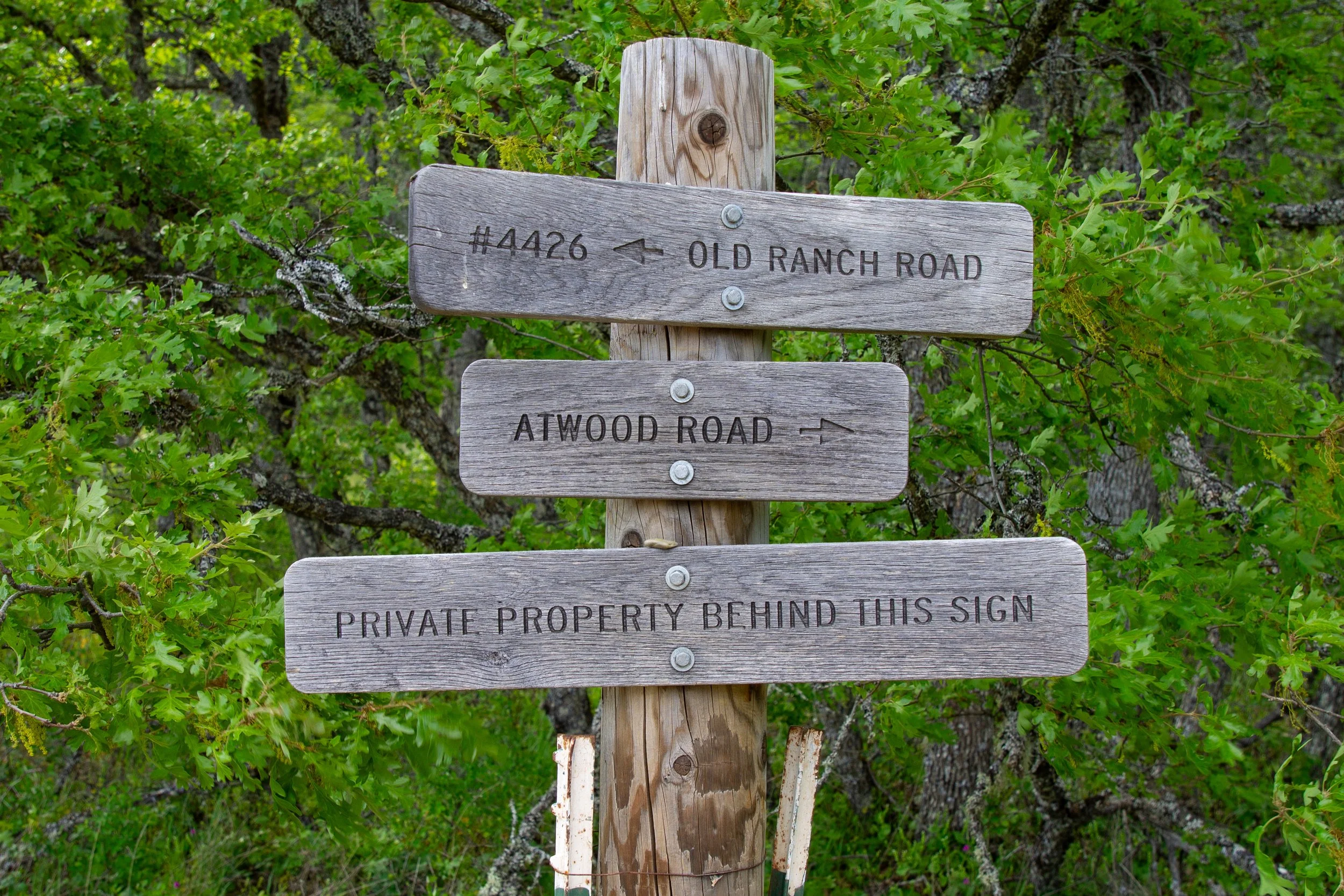
Follow the sign to Old Ranch Rd
When you reach Old Ranch Rd, you’ve finally finished most of the uphill climbing. Mount Hood has gone from being a speck above the hills to a snowy giant.

Mt Hood
Old Ranch Rd crosses a field with panoramic views of the Columbia Gorge. At the next trail junction, keep right onto the Coyote Wall Traverse Trail.

Old Ranch Rd
Keep left past a couple of trails leading to private property. When the trail splits at a confusing unmarked junction, keep left again. I had two different maps on my phone and kept checking them about every three seconds during this stretch.

Keep left here
The traverse trail ends at the Coyote Wall Trail. If you’re hiking in late April or early May, this hillside is where the balsamroot and lupines become fantastic.

Follow the sign to the Coyote Wall Trail
Once you start the Coyote Wall Trail, you’ll finally get to walk downhill. Lupines, balsamroot, and cluster lilies surround you. Mount Hood looms over the hills and cliffs of the Oregon side of the Gorge.

Balsamroot on the Coyote Wall Trail
Beneath the cliffs, you’ll see the Columbia River stretching out for miles. But do keep looking at your feet. I saw rattlesnake #2 here. It was a much closer call than #1 because I was entranced by the views.

Coyote Wall Trail
You’ll start seeing restoration areas around the trail. They’re easy to avoid. This part of the hike also gets baffling since at least two parallel trails keep intersecting each other. Do your best and keep heading downhill.

Balsamroot on the Coyote Wall Trail
The trail follows Coyote Wall, where cliffs rise dramatically above a forest. Clumps of desert parsley and buckwheat grow in rocky crevices.

Coyote Wall
If you stay along the cliff, Coyote Wall Trail becomes Little Moab Trail. Follow it until the junction with Old Ranch Rd, marked with a sign, then keep right to continue down the hill.

Almost done
At the next junction, you’ll see a sign pointing toward the trailhead. Follow it to reach the paved road again. Take the paved road to the right to return to the parking lot.
Getting there
To reach the Coyote Wall Trailhead from Portland, take I-84 E until Hood River, then cross the Hood River Bridge into Washington. Turn right onto Highway 14 and continue for 4.6 miles. Turn left when you reach Courtney Rd, then take an immediate right into the parking area on Old Highway 8. The drive takes about 70 minutes.
Or, drive to Vancouver and take Highway 14, which saves the $3.50 toll each way and adds about 20 minutes of drive time.
If the Coyote Wall Trailhead parking lot is full, drive east on Highway 14 for another 1.3 miles. Look for the parking area for the Syncline Trail East Trailhead on your left. Take the paved road west to start the hike.
Enjoy your hike at Coyote Wall!
With love,
Emma
Explore nearby


Check out the best things to do in Hood River.