

Lyle Cherry Orchard Trail


Update: The Lyle Cherry Orchard Trail is closed indefinitely due to wildfire damage. As of 6/30/26, no reopen date is scheduled. Check current conditions before visiting.
Lyle Cherry Orchard has a feeling I’ll never be able to convey with words or pictures. It’s not for lack of trying. I’ve been about five times, each time thinking I’ll take a photo that captures the land’s scale and grandeur. I never do. You need to be there to feel what a tiny speck you are. This hike is known for wildflowers, but I’d say they have a supporting role, emphasizing the vastness of everything around them. It’s a place of sweeping vistas and countless small details. You’ll have a few hiking options, ranging from 4.5 to 6.5 miles, including the new-ish Discovery Loop Trail. Here’s everything you need to know about hiking at Lyle Cherry Orchard.

Lyle Cherry Orchard has excellent spring wildflowers
Know before you go:
Parking is free in the unlabeled gravel lot by the Lyle Cherry Orchard Trailhead. You don’t need a pass.
The trailhead doesn’t have restrooms or other amenities. There’s a rest area a few miles to the west. Doug’s Beach State Park has vault toilets about a mile east.
The Lyle Cherry Orchard hike has two connecting loops. If you do one of them, the total distance will be 4-5 miles, or you can do both for a 6.5-mile hike.
Wear long pants and closed-toed shoes. The trails have a lot of poison oak along them. Check for ticks after your hike.
Watch your step. I had a memorable jump scare with a rattlesnake on this trail once.
Leashed dogs are welcome on the Lyle Cherry Orchard trails.
The hike is near drop-offs that are easy to avoid. Younger kids might struggle with the uphill walking, but older kids would be fine.
Wildflowers bloom as early as February through June, peaking around the end of April. Please stay on the trail and don’t pick the flowers.

Lupines peak around early May
On the Lyle Cherry Orchard Trail
Distance: 6.5 miles with two connected loops
Elevation gain: Up to 1,500 feet
Difficulty: Moderate
Pass required: None
Dog friendly: Yes, leashed dogs are welcome on the trail.
ADA access: No
Season: Any
The details
From the parking lot, look for a narrow dirt trail in the tree cover. It’s unlabeled other than a post with rules on it. This is the Lyle Cherry Orchard Trailhead.

Start here
The first quarter mile is mostly about getting up the switchbacks to better things ahead, but you’ll start seeing some wildflowers. Lupines, yarrow, and ookow were blooming on my early May hike.

Ookow along the trail
After a short distance, you’ll reach two large signs. One has a great detailed trail map. The other is the carved wood sign for the Cherry Orchard Trail. Ignore the 2 miles that it advertises. It’s longer. The warnings about poison oak and rattlesnakes are accurate. Use the boot brush to clean your shoes and take the trail to the right. To the left is the old convict road, an abandoned early 20th-century project to build a road through the Columbia Gorge using convict labor. It’s not a bad side trip if you have energy after the Lyle Cherry Orchard hike. You’ll follow a ridge along the Columbia River. It’s narrow, unmaintained, and next to steep drop-offs, so I’d skip it with kids.

Head to the right at the sign
Back to the Lyle Cherry Orchard Trail. You’ll walk up more switchbacks over rock scree. One of these is where I saw the rattlesnake.
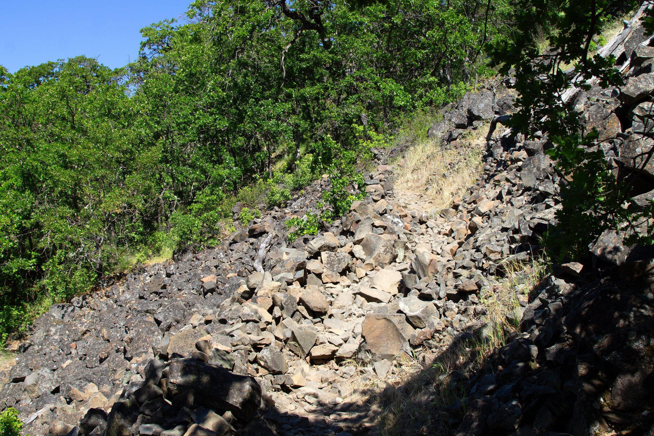
Watch for snakes
Clearings in the oak canopy reveal a cool basalt spire. You’re heading that way. You’ll also pass the first of the trail’s interpretive signs about the area’s ecology and history.

First cool rock formation
Once you get up the first hill and onto the basalt bench, the views become incredible. The trail levels off, temporarily, at a broad field where wildflowers bloom in spring. Winds off the Columbia River create ripples of silver in the new spring grass. Look for desert parsley, death camas, cluster lilies, and coastal manroot earlier in the season. Yarrow and lupines appear later.

Lupines along the Lyle Cherry Orchard Trail
Once you’re past the tree cover, you’ll have panoramic views of the Columbia Gorge. The rock that forms the rugged cliffs and spires is basalt from lava flows millions of years ago. Across the river, you’ll see the cliffs of Oregon slanting diagonally. This area is part of the Yakima Fold Belt, where tectonic plates push Oregon toward a more stable Washington, compressing the rock. One of the trail’s interpretative signs is about geology. Glacial floods up to 1,000 feet deep scoured this area around 15,000 years ago, helping to shape the cliffs.

Basalt bench at Lyle Cherry Orchard
As you walk past the basalt bench, you’ll see a couple of faint trails branching off to the left. You can walk a little way along them to explore the cliffs. The rocky ledges make great places for snack breaks. Otherwise, keep right and start heading uphill.

Signs along the Lyle Cherry Orchard Trail describe its history
You’ll reach a fork in the trail with a sign pointing you to the right. The top of the sign has a map. The trail to the left is the return of the Discovery Loop. Head right toward the Cherry Loop and Discovery Loop.

Keep right here
The trail makes switchbacks up toward the site of the old cherry orchard. You’ll have big views of the Columbia Gorge, making the climb go by faster than you’d expect. This hillside has Lyle Cherry Orchard’s one social media-famous sight, a slope of balsamroot. I’ve never been spot-on with the timing. The last few days of March are too early. The first few days of May are too late. I’m thinking mid to late April would be perfect if you want to capture the balsamroot specifically. Whenever you go, the views are unbeatable. For other wildflowers, the bloom season is generous. They can appear as early as February and last into June.

View from the top of the hill
Shortly after the trail levels off, you’ll reach a fork. It’s a decision point. The signpost has a trail map. To the right is the Cherry Loop. To the left is the Discovery Loop. You can:
Turn around here for a shorter hike, a little under 3 miles.
Hike the Cherry Loop and head back, about 5 miles.
Finish the Discovery Loop and head back, about 4.5 miles.
Do both, starting with the Cherry Loop, about 6.5 miles.
If you’re trying to decide between the loops, I’d steer you toward the Discovery Loop, which has more viewpoints and a couple of mountain sightings. It’s all pretty, though. You can’t go wrong even if you turn around here. My favorite views are from the climb up the hill.

The Cherry Loop and Discovery Loop split
Cherry Loop
If you do both loops, start with the Cherry Loop so you don’t have to retrace your steps. It’s a lollipop loop. In 0.7 miles, you’ll reach a 1-mile loop at the end. The trail winds through the site of the old Lyle Cherry Orchard. The trees are no longer cherries but Oregon white oak. There’s one cherry tree left somewhere that I’ve never spotted. In late spring, lupines, buttercups, and biscuitroot bloom under the oaks.

Cherry Loop
When you reach the loop at the end, keep left to do it clockwise. This part of the trail is one-way. A sign helps with directions.

Go left here
You’ll reach an unlabeled fork along the loop. Keep right. The highlight of the Cherry Loop is the broad clearing at the far end where lupines bloom in spring.

Cherry Loop
From the viewpoint, you’ll see the Columbia River and the grasslands of the eastern Columbia Gorge.

Viewpoint on the Cherry Loop
Most of the Cherry Loop is forested, but a short spur leads to another viewpoint, this time overlooking the Columbia Gorge to the south and west. A sign asks you to be quiet to avoid disturbing nesting falcons. The viewpoint is a favorite of birdwatchers. Chances are you’ll see people with their binoculars trained on the raptors and turkey vultures overhead.

Birdwatching spur
When you finish the Cherry Loop, you’ll be back at the junction with the Discovery Loop. Head left to return to the parking lot or right to see the Discovery Loop.
Discovery Loop

The Lyle Cherry Orchard Trail has several maps
The beginning of the Discovery Loop looks a lot like the Cherry Loop. It winds through an Oregon white oak forest where wildflowers bloom in the undergrowth. This trail is one of the newer ones in the Columbia Gorge, completed in 2021.
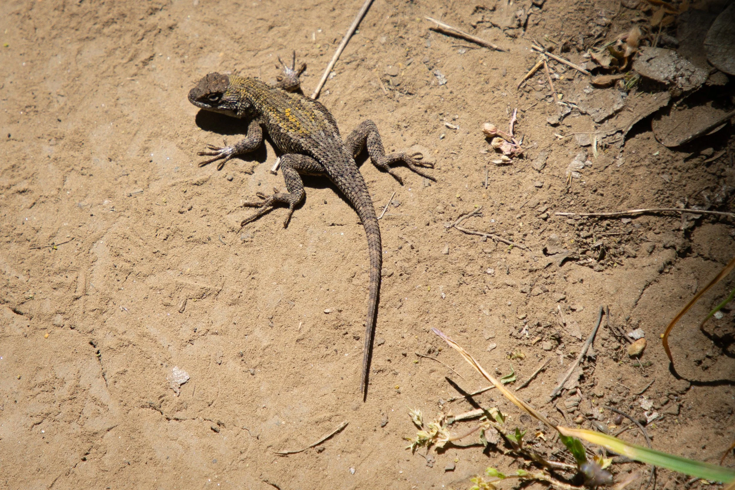
Fence lizard on the Discovery Loop
The Discovery Loop takes you to several viewpoints. The first is about a half mile from the junction with the Cherry Loop. Wildflowers cover a clearing that overlooks the Columbia Gorge to the west.

First viewpoint
Across the river, you’ll see Mt Hood’s summit sticking up above Oregon’s hills on clear days. As you round the corner, you’ll also get a glimpse of Mount Adams.

Mount Hood
From here, the Lyle Cherry Orchard’s Discovery Loop weaves in and out of the oak forest with frequent views of the Columbia River. It has some gentle ups and downs but nothing like the steep climb at the start of the hike.

The Discovery Loop has great views of the Columbia Gorge
On the far side of the loop, you’ll see the town of Lyle, Washington, at the bottom of the hill. A sign on the hillside labels the town in large white block letters in case there’s any doubt. This part of the loop has wonderful slopes of balsamroot and lupines. It’s not a social media star yet, but I’m guessing it will be soon. If you want to get it going next year, don’t forget me when you’re famous.

Lyle, Washington
At the end of the loop, the trail winds back around to the south side of the hill.

End of the Discovery Loop
When you reach the trail junction with the sign, you’re at the end of the Discovery Loop. Keep right to finish the Lyle Cherry Orchard hike and return to the parking lot.

Return journey to the Lyle Cherry Orchard Trailhead
Getting there
To reach the Lyle Cherry Orchard Trailhead from Portland, take I-84 East and cross into Washington at the Hood River Bridge. The bridge toll is $3.50 each way. Continue on Highway 14 East for 13 miles until you reach the unmarked gravel parking lot on your left. Parking is limited, but I’ve always found a spot even during popular times.
If you hate crossing the Hood River Bridge as much as I do (so narrow!), you can drive to The Dalles and cross at the much better Dalles Bridge for free. It adds about 10 minutes to the drive.
Enjoy your hike at Lyle Cherry Orchard!
With love,
Emma
Explore nearby


Check out the best things to do in The Dalles.

Take a day trip to Maryhill, Washington.