

Elowah Falls and Upper McCord Creek Falls Hike


The magnificent hike to Elowah Falls and Upper McCord Creek Falls tends to get overlooked despite being only a few miles away from the most popular waterfall hikes in Oregon’s Columbia Gorge. Although it sees fewer visitors than its neighbors, this hike offers just as much natural beauty, including two incredible waterfalls, a dramatic trail along a basalt cliff, and expansive views of the Columbia Gorge. If you’re looking for a secluded hike that packs in highlights over a short distance, this one is for you. Here is everything you need to know about hiking to Elowah Falls and Upper McCord Creek Falls.

Guardrails line the steepest parts of the trail to Upper McCord Creek Falls
Know before you go
This hike starts at the John B Yeon trailhead. Parking at the trailhead is free. You don’t need a pass. The parking lot is very small. Arrive early on the weekend, especially during summer.
Leashed dogs are welcome on the trail.
The trail is mostly family-friendly. Guardrails near the drop-offs keep it safe. The trail has some sections with loose rocks and unfenced drop-offs that might be a concern with younger children. Be aware of a missing section of guardrail on the way to Upper McCord Creek Falls.
The trailhead has no restrooms or other amenities.
The footbridge at the base of Elowah Falls collapsed. You can still reach the waterfall and then return the way you came. I’ve seen trail directions that say it is doable to cross the creek without the bridge. I would tend to disagree, but I’ve only done this hike in fall and winter. In drier seasons, you may be able to cross without the bridge.
The waterfalls will look most impressive in winter, early spring, and late fall. Look for wildflowers along the trail in late spring into summer.
Don’t leave any valuables in the car. Sadly, this area sees a lot of car break-ins.
There was some mud, slippery rocks, and running water on the trail when I visited. Although doable in sneakers, it will be easier in hiking boots.

Puzzling water tank near the trailhead
The Elowah and Upper McCord Creek Falls trail
Distance: 3 miles out and back
Elevation gain: 800 feet
Difficulty: Easy-moderate
Pass required: None
Dog friendly: Yes, leased dogs are welcome on the trail.
ADA access: No
Basic directions: From the trailhead, start heading uphill past the water tank. Keep left at the first trail junction. It is marked with a sign. You’ll soon reach a second, unmarked trail junction. Going left brings you to Elowah Falls and going right brings you to Upper McCord Creek Falls. Do each as a spur since the footbridge at Elowah Falls is out.

Expect amazing Columbia Gorge views from this trail
The details:
At the west end of the parking lot, you’ll find the trailhead and a sign that lists the distances to its various destinations. Head past the sign into the woods and you’ll see a large water tank releasing a constant stream of running water. Shortly after, you’ll reach the first trail junction. The fork to the right heads up the recently restored trail to Nesmith Point. Continue to the left to head towards the falls. A sign by this trail junction helps confirm the route.

The first trail junction is marked with a sign
Continue along the gradual but steady uphill through the charred forest, which was heavily impacted by the 2017 Eagle Creek wildfire. While the undergrowth has returned, few trees remain unscathed here. You’ll soon reach a second, unmarked trail junction. The fork to the left heads down to the base of Elowah Falls. The fork to the right goes up to Upper McCord Creek Falls. You can choose either direction to explore first. I prefer going left toward Elowah Falls first and ending with Upper McCord Creek Falls so that the return journey will be entirely downhill, but there isn’t a wrong way to do it.

Switchbacks bring you down to Elowah Falls
If you take a left at the unmarked trail junction, you’ll begin heading down switchbacks toward McCord Creek and the base of Elowah Falls. You’ll be able to see the falls and the creek below from a distance through the denuded trees. In winter this trail is muddy and has some loose rocks that will keep you looking at your footing as much as at the scenery.

My friend Denise approaches Elowah Falls
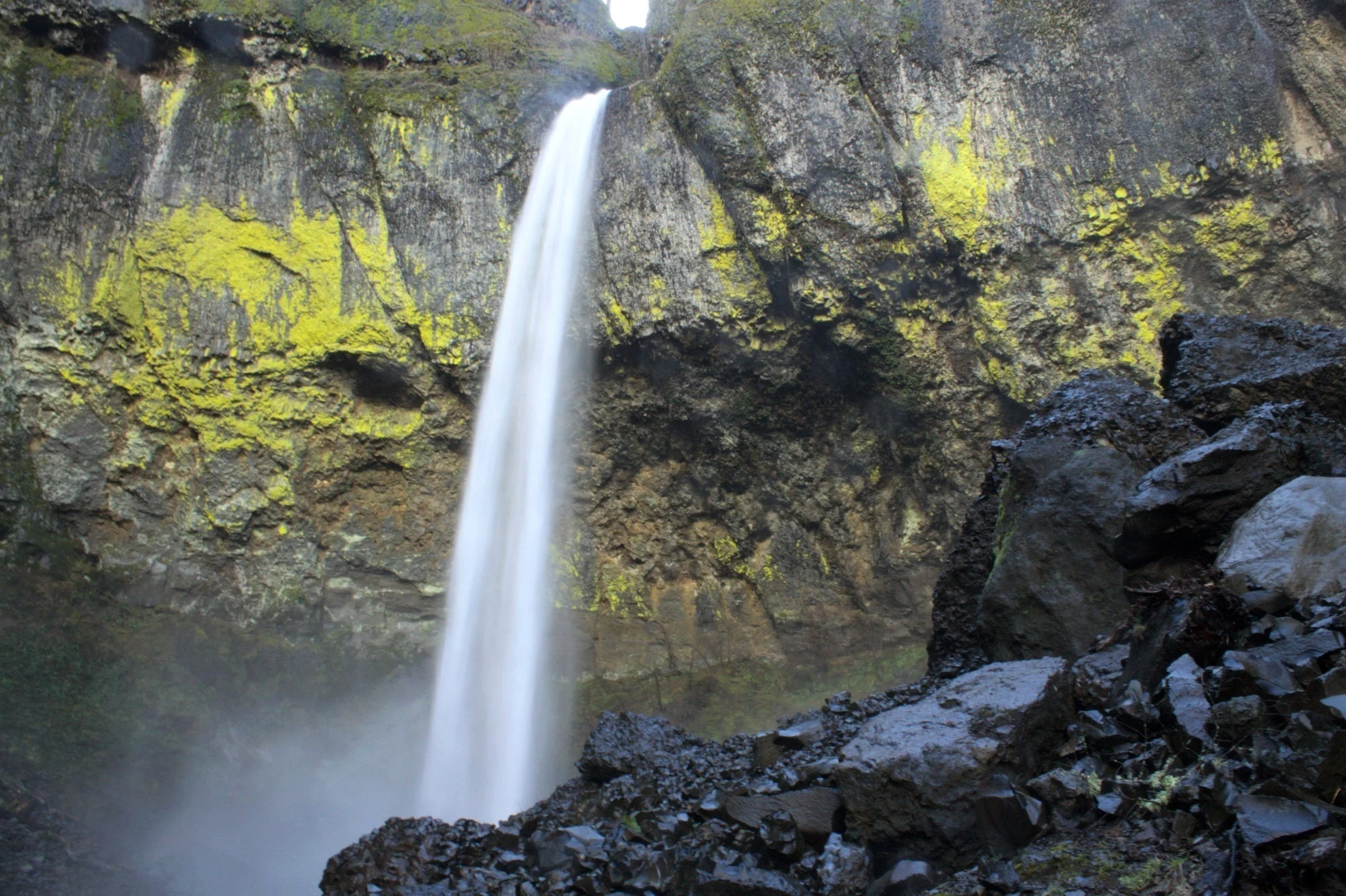
The views start to get great once you reach the base of the falls. The 213-foot Elowah Falls plunges over a lichen-covered cliff into a pool surrounded by piles of basaltic rocks and boulders. Clouds of mist spray from the falls and make the rocks around it dark and slick, looking almost like obsidian. It’s worth it to take your time admiring the cliff behind the falls. Look for rock layers within it that reflect different lava flows that came through the Gorge millions of years ago.

Elowah Falls
You’ll see the remains of the fallen footbridge in the creek, a casualty of a recent rockslide. Although it is tempting to see the falls from another vantage point, I can’t recommend trying to get across the creek based on the trail conditions when I have visited. I’ve read trip reports where people say the creek is traversable, which I suspect is true in summer when less water flows through the creek.

The footbridge is out at the base of Elowah Falls
When you’re done exploring around the base of Elowah Falls, return up the switchbacks until you are back at the unmarked trail junction. Take a left here to head uphill toward Upper McCord Creek Falls. From here, the views begin to change dramatically as you move up into the hills. I did this hike knowing I would see waterfalls, but I was not expecting to find such incredible views of the Columbia Gorge from the trail.

Look for Hamilton Mountain across the Columbia River
Once you get above the trees, the trail begins to hug a cliff of craggy basalt with guardrails along the side for safety. Over the guardrails, you will see open and expansive views of the Columbia River and the Washington side of the Gorge, including Hamilton Mountain and Beacon Rock. Expect to feel the continual dripping of water from overhanging basalt as you walk along this precipice.

Trail to Upper McCord Creek Falls
The trail will continue along the cliff as you round a corner and then reach a viewpoint of Elowah Falls from above. Note that this viewpoint is where a section of guardrail is missing. Looking down at Elowah Falls is a perfect way to appreciate its impressive basalt amphitheater, including some columnar jointing toward the top of the cliffs.

Elowah Falls from above
Shortly after passing the viewpoint for Elowah Falls, you’ll reach a much different waterfall, Upper McCord Creek Falls. Although at 64 feet tall it lacks the height of Elowah Falls, Upper McCord Creek Falls has a tranquil charm that will make you want to linger and admire the water falling over mossy basalt.

Upper McCord Creek Falls
From here, the trail continues only slightly farther, following the creek. Trail conditions also begin to decline. I was surprised but oddly pleased to walk through a stream running along the trail for maybe 0.1 miles.

The trail near Upper McCord Creek Falls became a stream
Soon after Upper McCord Creek Falls, you’ll reach a large fallen tree that blocks the trail. You can climb over with a bit of trouble, but it doesn’t get you anywhere besides a little closer to the creek. I’d say it’s not worth the scramble. Take a last look past the top of Upper McCord Creek Falls to admire the Columbia Gorge across the river and then return the way you came. Take a left when you get back to the unmarked trail junction to reach the parking lot.

Beacon Rock
Bonus hike options
The John B Yeon trailhead can connect you to several Columbia Gorge destinations besides Elowah Falls and Upper McCord Creek Falls.
The hike to Nesmith Point begins here, although at over 10 miles roundtrip in length and with nearly 4,000 feet of elevation gain, it is a very different commitment level than the short and sweet waterfall hikes. My bum leg and I have not done it. If you are training to hike up a mountain, this one is for you.
On the east end of the parking lot, you’ll see the start of the Bonneville segment of the Historic Columbia River Highway State Trail. This relatively flat paved trail extends east to Cascade Locks. Hiking this trail isn’t necessarily the most pleasant since it is so close to the interstate. You might want to head down as far as the McCord Creek Bridge (about 0.5 miles), which crosses pretty McCord Creek. You can see a sliver of Elowah Falls far from the east side of the bridge. Unlike the hike to the waterfalls, this trail is universal access.
Getting there
To reach Elowah Falls and Upper McCord Creek Falls from Portland, take I-84 East until Exit 35. Keep left to continue onto the Historic Columbia River Highway. Take an immediate right onto Frontage Rd and continue for about 2 miles. Look for the parking lot for the John B Yeon Trailhead on your right. The drive from Portland takes about 45 minutes.
From Hood River, take I-84 West until Exit 37. Continue onto NE Warrendale Rd and follow it for about 0.7 miles. Turn left to pass underneath the highway and then left again onto NE Frontage Rd. Look for the parking lot on your right. The drive from Hood River takes about 30 minutes.
Enjoy your hike to Elowah Falls and Upper McCord Creek Falls!
With love,
Emma
Explore nearby

Check out the other best hikes near Multnomah Falls.

Find other hidden gem hikes near Portland.

Try the best waterfall hikes near Portland.