

Angel’s Rest Trail

Although Angel’s Rest is one of the closest Columbia Gorge hikes to my home in Portland, I almost never go. Why? Everyone else is already there. Locals love it, and sometimes it seems like only it. I’ve had trouble finding parking on a frigid winter morning on a weekday. So why write about it? Giving credit where credit is due, it’s a phenomenal hike only 30 minutes away from downtown Portland. The views of the Columbia Gorge are spectacular, the wildflowers are a treat in spring, and there’s a cool waterfall around the halfway point. Morning people and people with weekdays off, here’s everything you need to know about hiking to Angel’s Rest.

Chipmunk at the Angel’s Rest Viewpoint
Quick stats
Distance: 4.8 miles out and back
Elevation gain: 1,500 feet
Difficulty: Moderate
ADA access: No
Know before you go
Cost: Parking at Angel’s Rest requires the Oregon State Park Pass, $10/day or $60/year. Parking is allowed from 6 AM - 10 PM.
Crowds: This hike is one of the most popular in the Columbia Gorge. The parking lot fills up quickly, especially on summer weekends. An overflow parking lot is on Palmer Mill Rd, which also fills up. I’d suggest arriving before 8 AM or after 2 PM on summer weekends. In winter, arriving by 10 AM should be safe. If you can visit on a weekday, you should be okay whenever.
Restrooms: Look for the nearest restrooms about 0.5 miles to the west, next to the Bridal Veil Falls parking lot. Neither of the parking lots for Angel’s Rest has a restroom.
Dogs: Leashed dogs are welcome on the trail to Angel’s Rest.
Kids: There are steep drop-offs at the Angel’s Rest viewpoint. I wouldn’t recommend going all the way to the top with small children. You can still get excellent views by hiking almost to the top, which avoids the drop-offs.
Season: This trail is usually great for year-round hiking. I’d skip it or turn around early if it is icy or very windy. Coopey Falls is a good turnaround point when the weather doesn’t cooperate.

The trail to the Angel’s Rest Viewpoint ends at an exciting finale
On the trail to Angel’s Rest

The first half of the hike to Angel’s Rest is through the woods
From the main parking lot for Angel’s Rest, the trailhead is across the road. If you park in the overflow lot, look for some stairs leading up to a dirt trail. These two trails merge after about 0.1 miles, so don’t worry about where you start. The first trail junction is where these trails meet. You’ll see a signpost (no sign) at this junction. From the main parking lot, head left at the junction. From the overflow lot, head right. Either way, you should be heading away from the unlabeled signpost.

The trails for the two parking lots merge at an unlabeled signpost
The hike begins in the forest where a canopy of Doug firs provides good shade. The burnt trunks here are a legacy of the 2017 Eagle Creek wildlife. Look for trillium blooming among the sword ferns in the undergrowth as early as March. You’ll be walking uphill starting from the trailhead, a trend that will continue throughout the hike. Although never very strenuous, it also never levels out.

This clearing provides a preview of the vistas to come
After about 0.5 miles, you’ll reach a clearing where a landslide left a rock scree field in its wake. A few maple trees on this slope turn a lovely yellow in the fall. The views in this clearing are the first, although by no means the best, of the Columbia Gorge you’ll see on this hike.

Look for the first views of the Columbia Gorge after about 0.5 miles
In another 0.3 miles, you’ll be back in the woods when you pass a sign reassuring you that you are moving away from the parking lot.

Walk past this sign and you’re almost to the waterfall
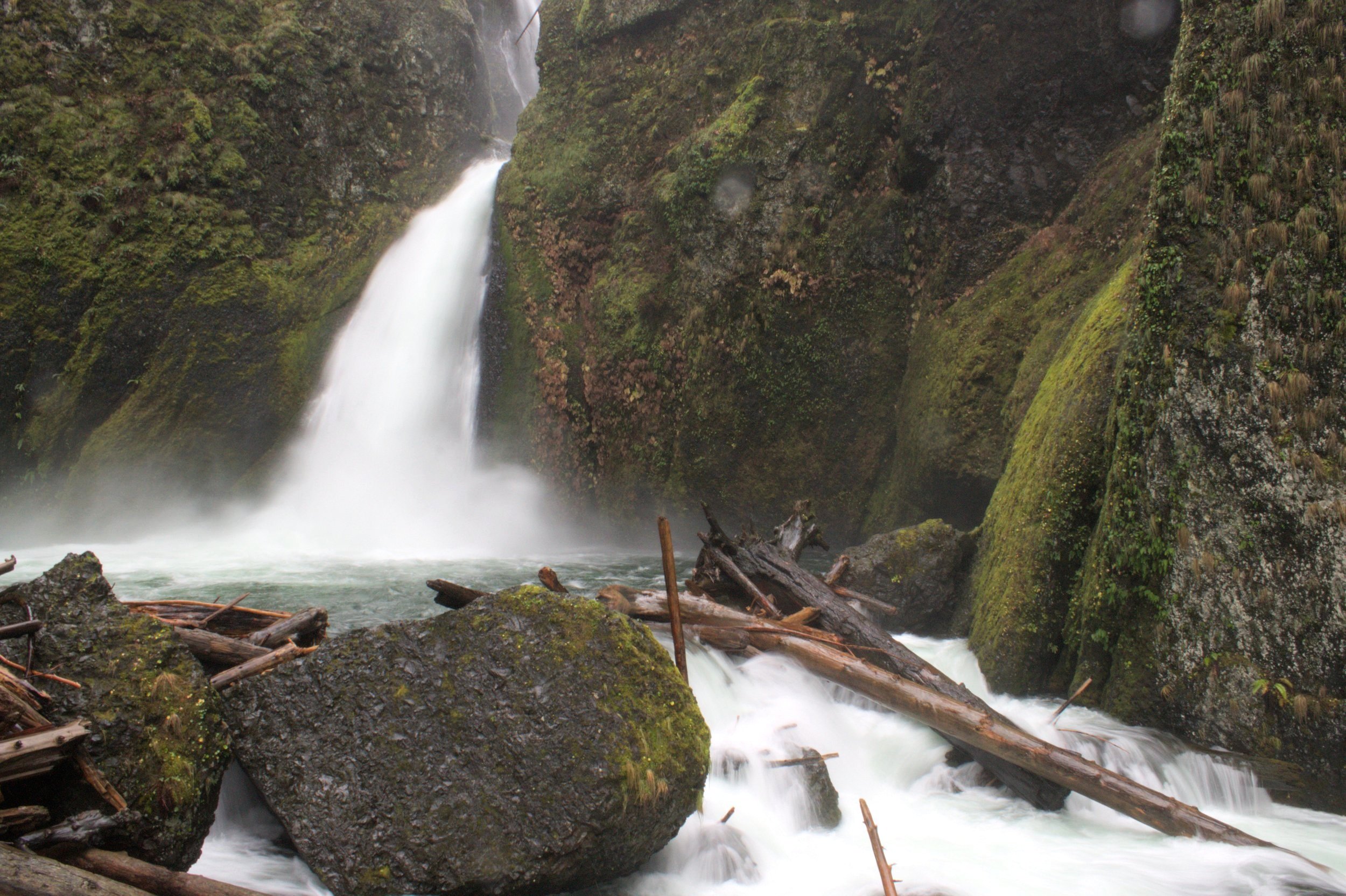
Near this sign, you’ll see a short spur to your left that heads out a viewpoint for Coopey Falls. Approach it with caution. Steep drop-offs surround this unfenced viewpoint. In summer, you’ll see only a hint of the 150-foot waterfall through the dense greenery. In winter, the views are less obscured, although still somewhat unsatisfying. Return to the main trail for a better angle up ahead.

Coppey Falls is easiest to see in winter
Back on the main trail, you’ll soon see another spur trail to the left. This one leads to an up-close view of Upper Coopey Falls.

Head left to see the waterfall
It’s easy to see Upper Coopey Falls by starting on the short spur. You can reach the base of the falls from here with a bit of scrambling. Expect to negotiate blackberry brambles, loose rocks, and mud to make it to the end of the spur and the best angle for photography. If you just want to see a good view of the falls, you can skip the scramble and stop before the end of the spur.

Upper Coopey Falls
Once you’re back on the main trail, you’ll get a glimpse of Upper Coopey Falls from the top as well as Coopey Creek as it approaches the plunge.

Coopey Creek as it approaches the falls
A footbridge will take you across Coopey Creek. This bridge makes a good turnaround point for a less intense hike that avoids areas with steep drop-offs.

A footbridge crosses Coopey Creek
From here, you’ll make your way up several gentle switchbacks. Look for a last view of Coopey Creek through the trees. After you’ve made it up a few switchbacks, you’ll leave the tree cover and get the first view of your destination, the Angel’s Rest Overlook. I thought it looked discouragingly far away and high up at this first sighting.

When the trail leaves the woods, you’ll get the first view of your destination
Once you get above the tree cover, the feel of the hike changes. The fire damage is much more noticeable since most of the remaining tree trunks are charred remnants. Wildfires affected this area in 1991 and then again in 2017. The undergrowth has filled in the gaps in the years since the fire. Look for wildflowers aplenty here in late spring, like columbine, penstemon, and irises.

Irises bloom along the trail in spring
The sparse tree cover along the trail means you can admire the Columbia River and the forested slopes of Washington as you make your way up to the viewpoint. Although you’ll get a workout, switchbacks keep the grade manageable as you climb. Look for views of Silver Star Mountain and Washington’s Larch Mountain across the river.

You’ll see fantastic views of the Columbia Gorge long before you reach the top
Near the end of the hike, you’ll reach a rocky clearing where it can be easy to lose the trail among the chunky slabs of andesite. This clearing has excellent views of the Columbia Gorge to the west and is a good stopping point if you want to avoid steep drop-offs. You can find some flat boulders here perfect for eating lunch.
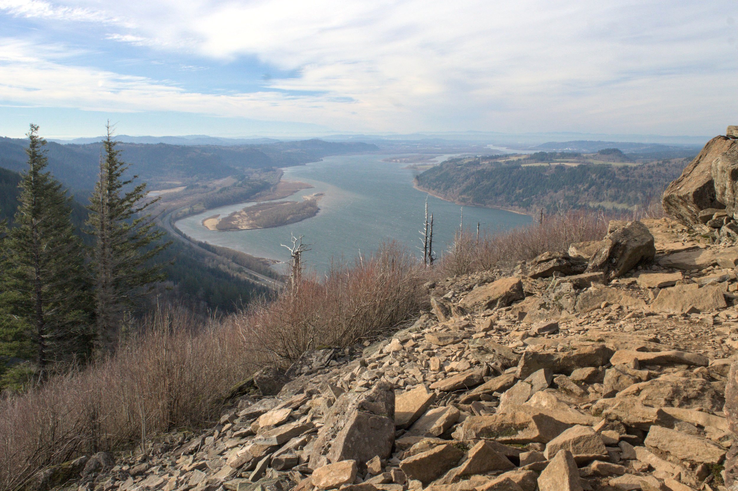
This viewpoint is a good place to turn around for a safer hike
Follow the now indistinct trail through the talus slope. It will look like you are leaving the views behind, but the best is yet to come. You’ll soon reach a trail junction. Go left here. The trail will take you to an impressive rocky spine surrounded by panoramic Columbia Gorge views. This andesite ridge was deposited by eruptions from the Boring Volcanics within the last million years.

Follow this ridge to the end to reach the best views
Continue on the trail to head up the ridge. This journey is not particularly difficult or technical, although I think I remember my hands getting involved at some point during the climb. Follow the ridge out to the end to find unobstructed Columbia Gorge views in three directions.

To the north, you’ll see the hills and peaks of Washington
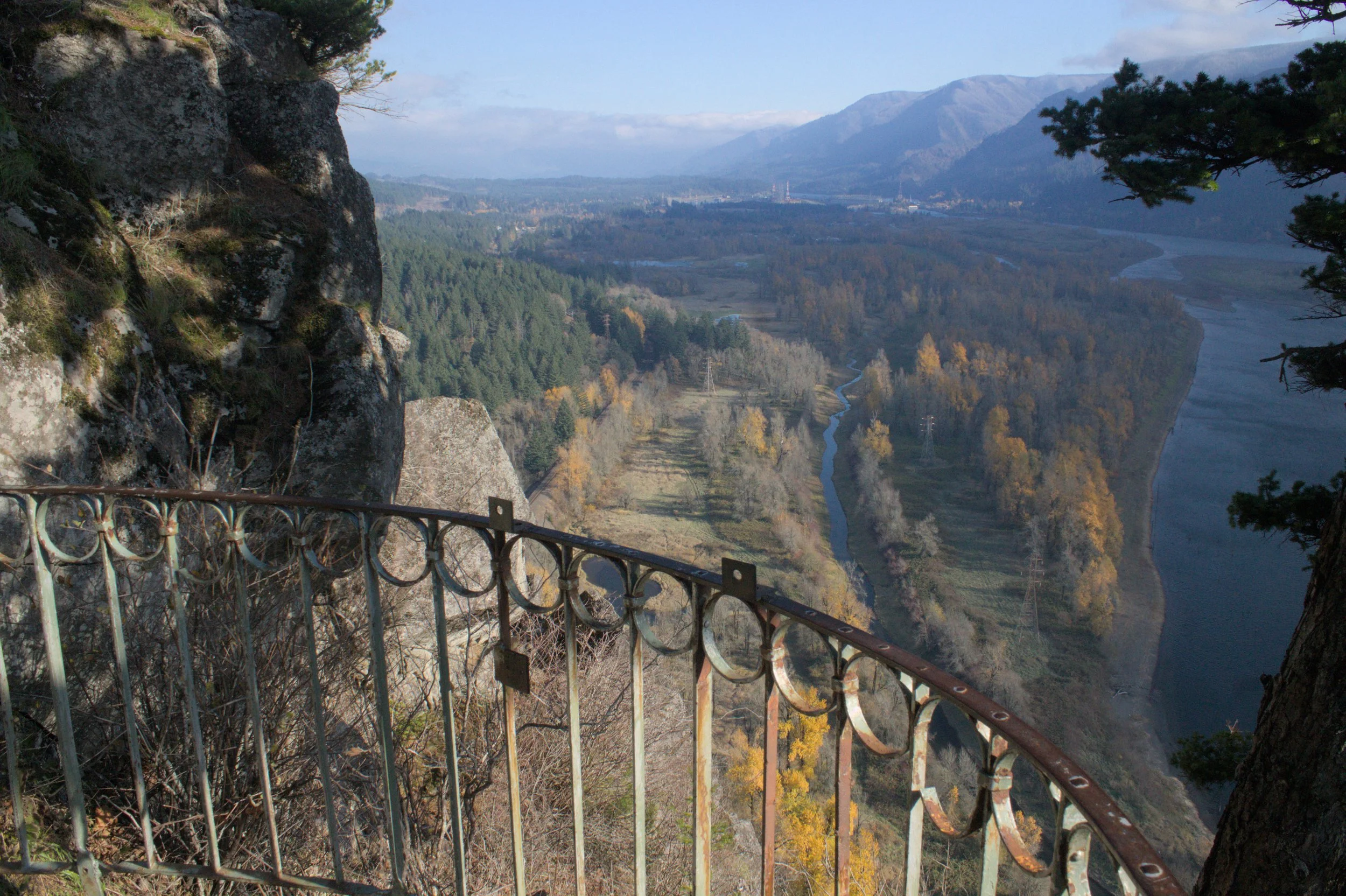
Across the Columbia River, you’ll see Washington’s Larch Mountain, Silver Star Mountain, Beacon Rock, and Hamilton Mountain on a clear day. Flowering bushes and a few irises add a delicate charm to the views in late spring. Look for chipmunks and Steller’s jays on the rocks. Overhead, watch for bald eagles, ospreys, and turkey vultures. You might spot a seasonal waterfall through the trees on the hillside just east of Angel’s Rest.

This perch offers great views to the west
The trail circles the edge of the Angel’s Rest promontory, allowing you to take in the views from different angles as you explore. To the west, look for Cape Horn and, on a clear day, the distant skyline of downtown Portland. Although it can get crowded, Angel’s Rest has lots of room to spread out. Even on the weekend, you can find comfortable rocks to sit on while you take in the views. Have a snack and take your time before returning the way you came.

Looking east, watch the Columbia River makes its way toward Portland
Longer hike options

Fairy Falls
For a more challenging day hike with gorgeous views, you can continue past Angel’s Rest to try out the 10.4-mile Devil’s Rest Loop.
To see Angel’s Rest, Devil’s Rest, and Wahkeena Falls, you can start at the Wahkeena Falls Trailhead and make a 9-mile loop. This hike leaves out Coopey Falls, but seeing Wahkeena Falls, Fairy Falls, and the cascading Wahkeena Creek is ample consolation.
Getting there
To reach the Angel’s Rest Trailhead from Portland, take I-84 E until Exit 28 towards Bridal Veil. Turn right, then continue on East Bridal Veil Rd until the road ends at the Historic Columbia River Highway. Take a right onto the Historic Columbia River Highway, then an immediate right into the main parking lot for Angel’s Rest.
If the main parking lot is full (as it often is), continue about 0.1 miles and turn left onto Palmer Mill Rd to park in the overflow lot. The drive from Portland takes about 30 minutes.
Enjoy your hike to Angel’s Rest!
With love,
Emma
Explore nearby

Check out the best waterfall hikes near Multnomah Falls.
Check out the best hikes in Beacon Rock State Park.
See all suggestions for the Columbia Gorge.