

4 Relaxing Hikes on Sauvie Island

Only 20 minutes from downtown Portland, Sauvie Island is a perfect getaway when you’re craving time in nature without a long drive time or complicated logistics. It’s a place I tend to visit on a whim. Beyond the farms and beaches that draw most visitors to the island, the hiking trails are worth a closer look. They’re not so much about the wow factor as enjoying moments of quiet beauty in meadows, oak savannas, and wetlands. All the trails are flat and easy. Most are short enough to stop by after work or a day spent fruit picking in one of the orchards. Here are the best places to go hiking on Sauvie Island.

Wapato Access Greenway
Tips for hiking on Sauvie Island
To park at most trailheads on Sauvie Island, you’ll need the ODFW Wildlife Area Permit. It’s $10/day or $30/year. Buy one online.
Bugs can be a nuisance on the trails. Wearing bug spray is a good idea if you’re hiking in the summer.
Some trails close seasonally to protect migrating birds that visit Sauvie Island. The Wapato Access Greenway and Warrior Rock Lighthouse Trail are open all year.
Leashed dogs are welcome on Sauvie Island’s hiking trails.
Wapato Access Greenway

Multnomah Channel
Season: All year
Distance: 2.4-mile loop
Elevation gain: Minimal
Difficulty: Easy
Pass required: None
Dog-friendly: Yes, leashed dogs are welcome on the trail.
ADA access: No
Amenities: Picnic shelter

The Wapato Access Greenway is Sauvie Island’s most convenient hike. You can skip the hassle of getting a parking permit. It’s free to visit and open all year. The parking lot is five minutes away from the bridge onto the island. The road is paved the whole way and doesn’t involve miles of bumps, unlike some trailheads I could name (Warrior Rock). The lot is small and can fill up, but I’ve never had trouble finding a spot, even on a beautiful Saturday. The trail is a scenic loop around a seasonal wetland. It’s less about show-stopping features and more about the subtler highlights. The gentle walk through the forest has shade most of the way. A couple of spots overlooking the marsh are great places to watch for birds and deer. A short spur trail leads to a dock on the Multnomah Channel where you can get down to the water. The hike doesn’t take long to complete and is easy to combine with a visit to Sauvie Island’s farms. Topaz Farm is about two minutes away.
Oak Island Nature Trail

Season: Open April 16th - September 30th
Distance: 2.7-mile loop with a spur
Elevation gain: Minimal
Difficulty: Easy
Pass required: ODFW Wildlife Area Permit
Dog-friendly: Yes, leashed dogs are welcome on the trail.
ADA access: No
Amenities: Port-a-potty at the trailhead

Mount St Helens
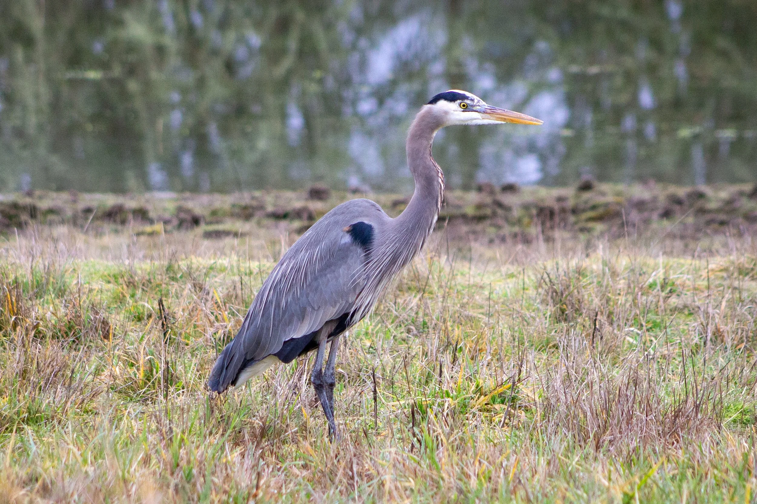
Sauvie Island’s Sturgeon Lake makes a lopsided horseshoe shape around a peninsula called Oak Island. The Oak Island Nature Trail is unlike most hikes near Portland. All about sunshine and wide open spaces, it’s a great destination when the sun finally comes out after a long string of rainy days. The trail makes a loop around the peninsula, passing through fields where cows graze and swallows flit above the grasses. Nearby is an Oregon white oak forest full of ground squirrels and songbirds. Like the Wapato Access Greenway, this hike is more about the journey than the destination but it does have the added excitement of mountain peaks. From the end of the peninsula, look for Mount St Helens, Mount Hood, and Mount Adams on a clear day. Sturgeon Lake is a good place to watch for ducks, geese, and herons. If you visit at the end of April or early September, you might see sandhill cranes.
Learn more about the Oak Island Nature Trail.
Mud Lake

Season: Open April 16th - September 30th
Distance: Up to 5-mile loop
Elevation gain: Minimal
Difficulty: Easy
Pass required: ODFW Wildlife Area Permit
Dog-friendly: Yes, leashed dogs are welcome on the trail.
ADA access: No
Amenities: Port-a-potty at the trailhead

The trail around Mud Lake is one of Sauvie Island’s most obscure hikes. I went after visiting the Oak Island Nature Trail, wanting to make the most out of my $10 parking permit. Mud Lake isn’t a promising-sounding name and I came without expectations. Once I started the trail, I was pleasantly surprised by this lovely walk alongside Sauvie Island’s wetlands and waterways. If the water levels are low enough, you can make a 5-mile loop around the lake when land bridges form between small islands. Late summer and early fall are safe bets if you want to do the whole thing. I managed it with some rock hopping in early June. You’ll see lots of animals on this hike. Most of them will be cows and they’ll be smack dab in the middle of the trail looking at you like you’re an uninvited guest, but there’s also great bird-watching potential. I saw more herons than people on a beautiful evening hike. Ducks, geese, egrets, and pelicans also visit Mud Lake. Look for views of Mount St Helens and Mount Hood on a clear day.
Warrior Rock Lighthouse Trail

Warrior Rock Lighthouse
Season: All year
Distance: 6 miles (to Warrior Rock Lighthouse) or 7 miles (Warrior Point), out and back
Elevation gain: Minimal
Difficulty: Easy
Pass required: ODFW Wildlife Area Permit
Dog-friendly: Yes, leashed dogs are welcome on the trail.
ADA access: No
Restrooms: Port-a-potty at trailhead

Warrior Point
Most of Sauvie Island’s hiking trails are gentle strolls in nature without a clear finale. The Warrior Rock Trail is an exception. It ends at the island’s most satisfying destination, Warrior Rock Lighthouse, the smallest lighthouse in Oregon. The hike to reach it follows the Columbia River. You can start on the beach before cutting back over to the trail through the forest. Several more spots along the way provide easy water access. Look for Mount St Helens across the river on a clear day. Once you reach the lighthouse, it’s worth getting up close to see the murals decorating its sides. On a hot day, you might want to linger at Warrior Rock Beach just north of the lighthouse. Since you can only reach it by hiking, it stays less crowded than most of Sauvie Island’s beaches. If you continue walking north on the beach for about half a mile, you’ll reach Warrior Point, the northernmost tip of Sauvie Island. Warrior Point is where the Multnomah Channel rejoins the Columbia River. Look for the town of St Helens, Oregon, across the water.
Learn more about the hike to Warrior Rock Lighthouse.

Warrior Rock Lighthouse
Best hikes on Sauvie Island, the summary:
Wapato Access Greenway
Oak Island Nature Trail
Mud Lake
Warrior Rock Lighthouse
Enjoy your day on Sauvie Island!
With love,
Emma

After your hike, check out the Sauvie Island beaches.

Find the best things to do on Sauvie Island.
Find great birdwatching near Sauvie Island at Ridgefield National Wildlife Refuge.