

Quick Guide to Hug Point
Closure update: As of November 2025, Hug Point is closed due to beach erosion. Oregon State Parks hasn’t given a reopening date yet.
Visiting Hug Point feels like stumbling onto a secret. Don’t get me wrong, it’ll be crowded. It’s a gorgeous park only a few minutes away from Cannon Beach, one of the Oregon Coast’s most popular destinations. If you find a parking spot, exploring the hidden corners of this tucked-away cove makes it seem like a discovery, no matter how many others are with you on the beach. Sitka spruce forests grow on dramatic cliffs of sandstone and basalt. Tidepools, sea caves, and a seasonal waterfall become accessible at low tide. If your timing is right, you can reach the most unique and surprising part of this park, an old road encircling Hug Point that stagecoaches once used to travel along the coastline. Here’s everything you need to know about visiting Hug Point State Recreation Site.

Hug Point Waterfall
Know before you go
To make the most out of your trip, visit Hug Point State Recreation Site at low tide.
Parking is free at Hug Point. You don’t need a pass or permit. The parking lot is small and fills up quickly on summer weekends. Don’t park on Highway 101 if the parking lot is full. It’s illegal, and you might get a ticket.
There’s a restroom and a small picnic area near the parking lot.
Dogs are welcome at Hug Point State Recreation Site.
Exploring Hug Point isn’t so much a hike as a walk on the beach. There’s a set of stairs you’ll need to climb down to reach the beach from the parking area.

Giant green anemones at Hug Point
Tides and tide tables
Timing your visit to Hug Point based on the tides is more important than almost anywhere on the Oregon Coast. At high tide, you’ll be able to get to the beach, but a small headland will block access to the most interesting features at the north end. You can still explore the beach to the south, which is pretty in a way that’s typical of Oregon Coast beaches.
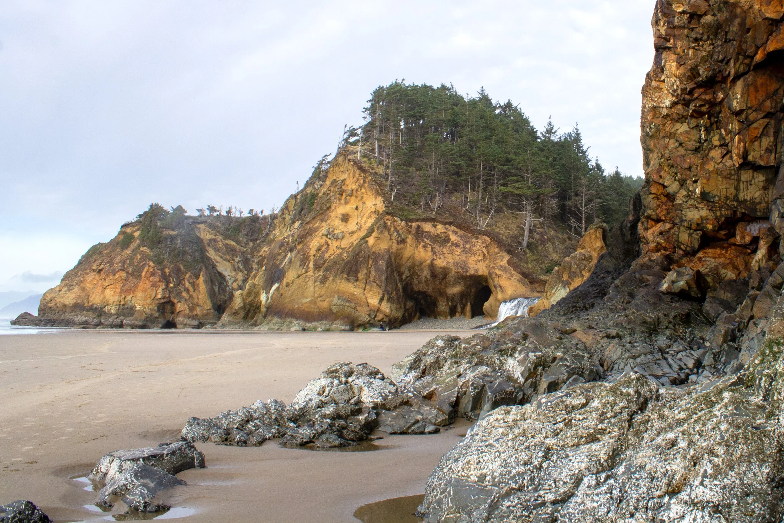
Visiting at a fairly low tide will allow you to get around the first headland to the north. On the other side, you’ll find a cove where Fall Creek spills onto the beach as a small, picturesque waterfall. In late summer, the Hug Point waterfall dwindles to a trickle. You’ll want to take your time exploring the cliffs here. Erosion of the sandstone has created intriguing recesses and alcoves around the waterfall.
A second, larger headland is on the north end of this cove, which is Hug Point. Look for the rock ledge that wraps around its base. You can walk around Hug Point on this ledge to Arcadia Beach if you visit at a very low tide. When I last visited, the tide was between 1-2 feet, which was not quite low enough to reach the ledge. If you see numbers on a tide table around or below zero, you should be good.
Pay close attention to the tides while you are exploring here. People do sometimes get stuck on the wrong side of Hug Point when the tide comes in. This tide table is specific to Hug Point State Recreation Site.

Hug Point at low-ish tide
What to see at Hug Point
High tide
Even if you visit Hug Point at high tide, don’t despair, there’s still a lovely beach to explore. From the parking lot, head down the stairs to the ocean. On the north end of the beach, take a moment to admire the vein of basalt running through the lighter sandstone in the cliff of the headland. This cliff is as far north as you’ll get at high tide, but head south for a nice walk along the beach. Arch Cape is in the distance.

Beach at Hug Point State Recreation Site at high tide
You can also still get a glimpse of Hug Point and its waterfall from above at high tide by seeking out a hidden viewpoint. From the parking lot, look for a small trail near the restroom that heads into a forest of Sitka spruce. Follow the trail through the dense salal understory until you reach a viewpoint overlooking the cove below (about 0.1 - 0.2 miles).

Hug Point at high tide
Low-ish tide
When the tide recedes, you can walk on the beach past the smaller headland to the north to reach the cove beyond. Here is where things start to get interesting. Look for the Hug Point waterfall, which will be prettiest from late fall until early spring when more water passes over it. Waves, storms, and wind have eroded the sandstone cliff next to the waterfall, forming irresistible caves and contours. The next headland is Hug Point. Around its base, you’ll see a road carved from the cliff. Unless the tide is very low, the ocean will block your path to this road.
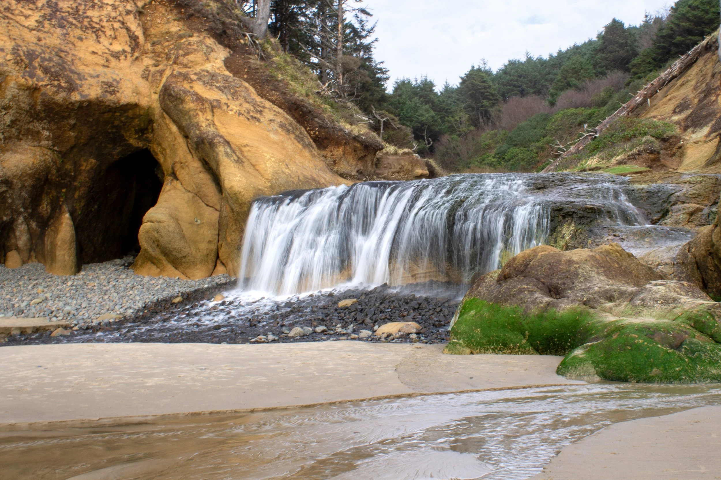
Hug Point Waterfall
Very low tide
When the tide is lowest, you can walk on the rocky ledge that was once a road used by stagecoaches to traverse Hug Point in the early 1900’s. Here, you feel like you are “hugging” the cliffside, true to how the headland got its name. This ledge is a great place to see tidepool critters like barnacles, sea stars, and anemones.

The road around Hug Point
On the other side of Hug Point, you’ll find Arcadia Beach. Be sure to look for the contorted sandstone in the cliffs as well as the algal-covered sea caves here if tidal conditions allow it. In the distance, you’ll see the sea stacks of Cannon Beach several miles to the north, including famous Haystack Rock.

Arcadia Beach
You can walk for miles along this beach, but I wouldn’t stray very far from Hug Point to keep from getting stranded when the tide comes in. Arcadia Beach has its own parking area just up the road, so if you move the car, you can take all the time you want there rather than worrying about the tides.
Hug Point History

Road around Hug Point
Before the construction of Highway 101 in the 1920s-30s, the easiest way to travel along the Oregon Coast was by using the beaches. Hug Point presented a challenge to travelers since its headland projects into the ocean, blocking the passage of stagecoaches and, later, automobiles.
Around the 1910s, workers blasted through the rocky headland to create the road at Hug Point, making the passage easier at low tide. You can see the wheel ruts that remain from the long-ago cars and wagons. After the construction of the highway, the road at Hug Point was no longer critical for travel, and the area eventually became a public park.
I was surprised to learn that there was once a family home just upstream of the Hug Point waterfall. If you’re interested, check out this article by the Cannon Beach History Center and Museum. Although the house is gone, rhododendron bushes remain at the site of its former driveway.
Geology of Hug Point

Basalt and sandstone form the cliffs around Hug Point
Around 16 million years ago, fissures opened in northeastern Oregon and southeastern Washington, erupting massive amounts of molten basalt. These lava flows traveled across the state for hundreds of miles before arriving at the northern Oregon Coast. When the lava reached the area around Hug Point, it interacted with the soft, sedimentary rock of the coastline. Today, the mostly sandstone cliffs around Hug Point have striking basaltic features. The most impressive of them is at the first small headland you’ll see to the north when you get to the beach. A distinctive vein of dark rock runs diagonally through the lighter-colored sandstone.
Getting there
Hug Point State Recreation Site is about 5 miles south of Cannon Beach and 10 miles north of Manzanita. If you’re driving south on Highway 101 from Cannon Beach, look for a nondescript right turn onto Beach Access Road that leads to the parking area for Hug Point. It’s just south of Arcadia Beach, and there will be a sign pointing the way from the highway. If you reach Arch Cape, you’ve gone too far.
The drive from Portland to Hug Point State Recreation Site takes about 1.5 hours. The drive from Seattle takes about 4.5 hours.
Enjoy your trip to Hug Point!
With love,
Emma
Explore nearby

Visit the extraordinary Ecola State Park.

Find the best things to do in Cannon Beach.

Explore the beaches and trails in Oswald West State Park.