

Mitchell Point Tunnel and Trail


Mitchell Point reopened to the public in the spring of 2025 after years of construction. Besides restoring access to the popular trail up the namesake peak, it now comes with a new attraction, the Mitchell Point Tunnel. This 655-foot underground passageway recreates one of the engineering wonders of the Historic Columbia River Highway. Take the short and easy trail through the tunnel to see its five arched windows. Then, if you’re in the mood for adrenaline, make the steep trek up Mitchell Point to reach 360 degrees of Columbia Gorge vistas. Here’s everything you need to know about visiting Mitchell Point.
The Mitchell Point Tunnel
Know before you go
It’s free to park at Mitchell Point. You don’t need a pass.
The parking lot is too small. Arrive early on the weekend. I came on Sunday around 10 AM and found a few spots open. By 1 PM, the lot was full and many cars were parked illegally. Keep in mind this is a newly reopened trailhead that’s still marked as closed on many resources. I have a feeling it’s about to be the next Angel’s Rest. My main concerns are pedestrian safety and wildfire risk. I saw cars parked on tall grass, which is going to be a tinderbox by the end of summer. If you don’t get a parking spot, the Mosier Twin Tunnels or Starvation Creek Waterfalls are great alternatives.
Leashed dogs are welcome on the Mitchell Point trails.
Restrooms and a couple of picnic tables are next to the parking lot.
Mitchell Point can be very windy. Bring layers.

Desert parsley blooms on Mitchell Point in spring
The trails
Three trails start from the Mitchell Point parking lot, giving it a choose-your-own-adventure feel. The first two are the main attractions and I’ll talk about them in more detail below.
To see the Mitchell Point Tunnel, take the Historic Columbia River Highway State Trail, the wide paved trail on the north side of the parking lot. This shared biking and hiking trail is stroller and wheelchair-friendly. Fences make it safe for families.
The smaller trail on the other side of the parking lot next to the restrooms leads to the top of Mitchell Point. It’s steep, unpaved, and has unfenced drop-offs at the top. Watch for poison oak. Wear long pants and closed-toed shoes, preferably hiking boots.
The Wygant Trail is the easy-to-miss trail by the parking lot entrance. If you can’t find parking at Mitchell Point and don’t mind a walk, you can take this trail to reach the Mitchell Point Tunnel. Start at Viento State Park (Oregon State Park Pass required, $10/day) and take the Historic Columbia River Highway State Trail east for two miles. Then, take the 0.7-mile temporary trail to Mitchell Point. The temporary trail is not bike, stroller, or wheelchair-friendly. Viento State Park to the Mitchell Point Tunnel is about 6 miles roundtrip.
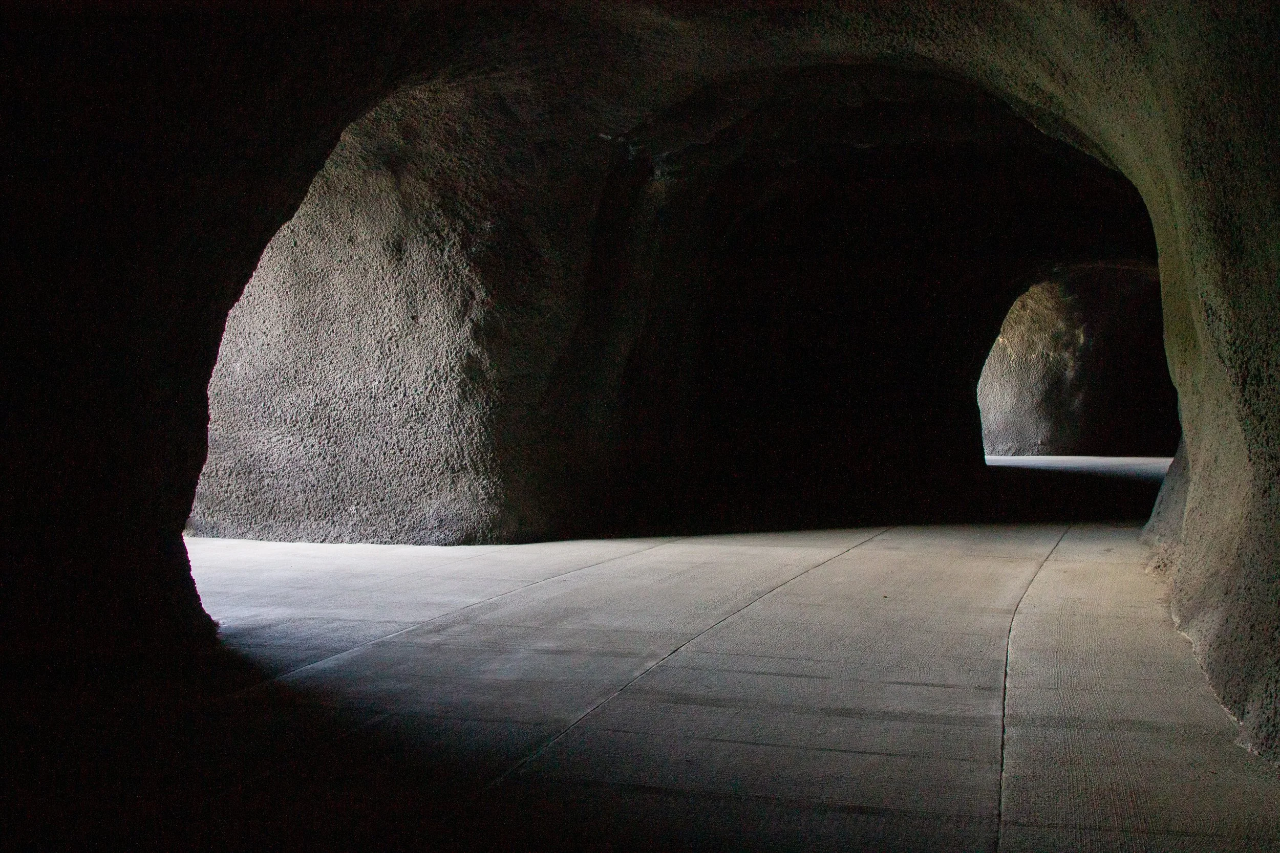
Mitchell Point Tunnel
Distance: 1.5 miles out and back
Elevation gain: Minimal
Difficulty: Easy
Pass required: None
Dog friendly: Yes, leashed dogs are welcome on the trail.
ADA access: The trail is wide, flat, and paved, without barriers like steps. It has a few benches. Accessible parking and restrooms.
Season: All year

Take this trail to the Mitchell Point Tunnel. It’s just past the cliff.
The details
The trail to the Mitchell Point Tunnel begins at a viewpoint overlooking the Columbia River and Washington’s Dog Mountain. The low stone wall around the viewpoint resembles the skilled masonry typical of the Historic Columbia River Highway, designed to emphasize the beauty of the landscape. Once the main route of travel through the Columbia Gorge, this car-free segment of the Historic Columbia River Highway State Trail is now for hikers and cyclists. In spring, the best wildflowers are at the top of Mitchell Point, but you can spot a few blooms along the trail, especially desert parsley.

First viewpoint
The Mitchell Point Tunnel entrance is just past the first viewpoint. Inside is a strange underground passage that looks like how I imagine life in an ant colony. The tunnel’s five arched windows let in enough light to make it through without a flashlight. Out the windows, you’ll see the Columbia River and the hills of Washington. The new Mitchell Point Tunnel recreates the tunnel that was here in the early 20th century. The original version was built in 1915 and demolished in 1966 to make way for Interstate 84.

Window in the Mitchell Point Tunnel
When the tunnel ends, you’ll be on the other side of Mitchell Point with more great views of the Columbia River. If you want to minimize hiking distance, you could turn around here. It would be about a half-mile roundtrip. The rest of the trail is lovely, but the tunnel has the most wow factor.

Tunnel exit
On windy days, whitecaps form on the river. Watch for trains passing on the tracks below you. Overhead, you might spot turkey vultures, ospreys, crows, or bald eagles.

Just after the tunnel is the trail’s second impressive viewpoint. From here, it curves away from the river. The scenery gets less dramatic, but you’ll get a break from the wind and the road noise.

Second viewpoint
The rest of the trail is a pleasant stroll past conifer-covered hills and maple trees. About a third of a mile past the second viewpoint, it ends at a residential street with a lot of no parking signs. From here, turn around and head back the way you came. This segment of the Historic Columbia River Highway State Trail is part of an ambitious project to restore the original 73 miles of the Historic Columbia River Highway. For now, it exists in stops and starts throughout the Gorge. In the future, it could connect Troutdale to the Dalles.

End of the trail
Mitchell Point Trail
Distance: 2 miles out and back
Elevation gain: 1,000 feet
Difficulty: Hard
Pass required: None
Dog friendly: Yes, leashed dogs are welcome on the trail.
ADA access: No
Season: All year. Skip it if it’s icy.
The details
Unlike the tunnel, the trail up Mitchell Point isn’t new, but it did reopen in 2025 after a years-long closure. I’d been once before it closed and was relieved to find it just as rewarding as I remembered. The trail is on the harder side for its length, but the views at the top are some of the best in the Columbia Gorge. Start at the unmarked trailhead near the restrooms. The pavement ends in about 100 feet when you pass a picnic table. From here, the trail is uneven and narrow.

Mitchell Point Trailhead
The hike begins with a steep climb through the woods. It doesn’t waste time with anything so mollycoddling as switchbacks. Nope, just straight up. In spring, you’ll start seeing wildflowers along the trail as you climb. Look for larkspur, prairie stars, and blue-eyed Mary.
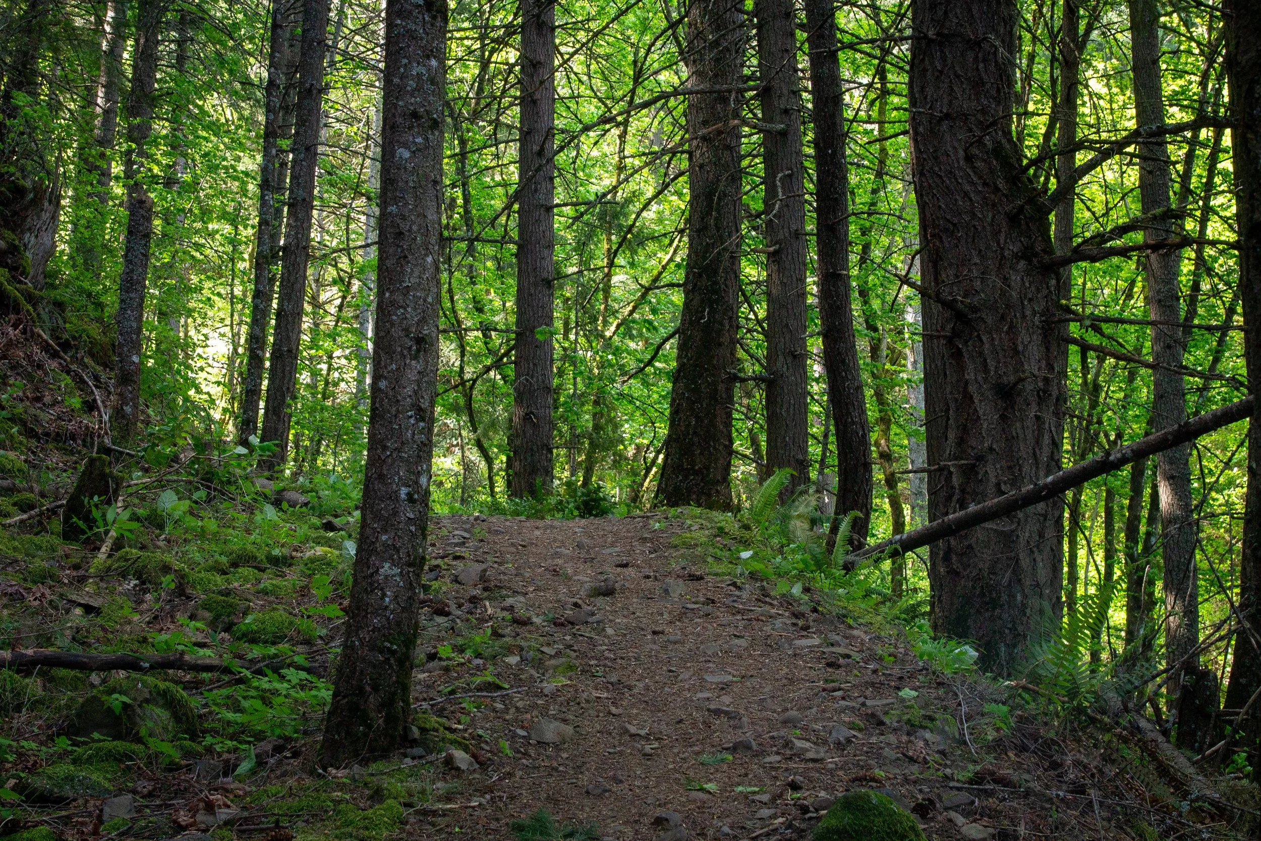
The Mitchell Point Trail starts in the woods
Partway up, you’ll reach a rock scree slope with a whole bunch of tippy rocks. The good news is that you start getting switchbacks.

Looking back, you’ll see the first Columbia Gorge views.

Drano Lake and Cook Hill across the Columbia River
The second half of the trail has more rock scree alternating with forested stretches. These woods are where I saw a single calypso lily, one of my favorite wildflowers. Also, so, so much poison oak. The trail is in decent shape given its long closure, but it is overgrown. Don’t wear shorts. You can’t always avoid brushing against the plants.

Calypso lily
When you reach the power line corridor, you’re almost done. Walk through a thicket of Oregon grape and you’ll arrive at a ridge looking onto the Columbia River to the east.

The view before the sketchy part
Now you have a decision to make. The last 0.1 miles of the trail is a steep climb up a crumbly ridge. You’ll have cliffs on either side. It will probably be windy. If you have kids or dogs, or just don’t like heights, I’d skip this part. Instead, head a short distance down the dirt access road along the power line corridor to see the river views from a safer vantage point. Otherwise, up we go.

Balsamroot near the end of the trail
The top of Mitchell Point is the best place on the hike to see wildflowers. Look for balsamroot and lupines joining the larkspur and desert parsley in spring. As you climb up the ridge, you’ll have Columbia River views on both sides.

To the west are Wygant Peak and Mount Defiance on the Oregon side of the river. Dog Mountain, Table Mountain, and Silver Star Mountain are across the Columbia. To the east, you’ll have a great view of the Columbia River and White Salmon, Washington.
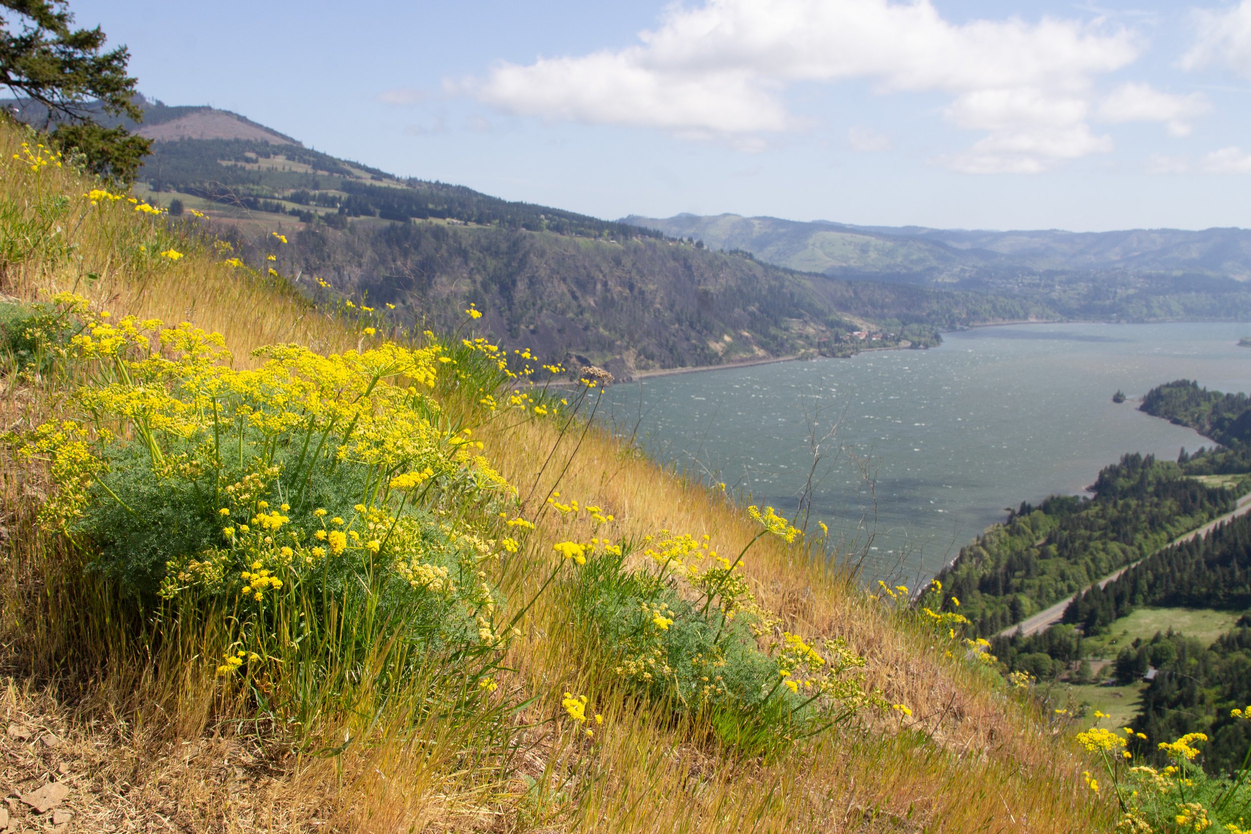
Desert parsley blooming on Mitchell Point in late April
At the top of Mitchell Point, you’ll get to a small plateau with a narrow ridge of cliffs beyond it. Stop here and admire the views in 360 degrees. If it’s clear, you’ll see the tiniest glimpse of Mount Adams over Washington’s hills. Don’t go past the little plateau. The cliffs aren’t safe.
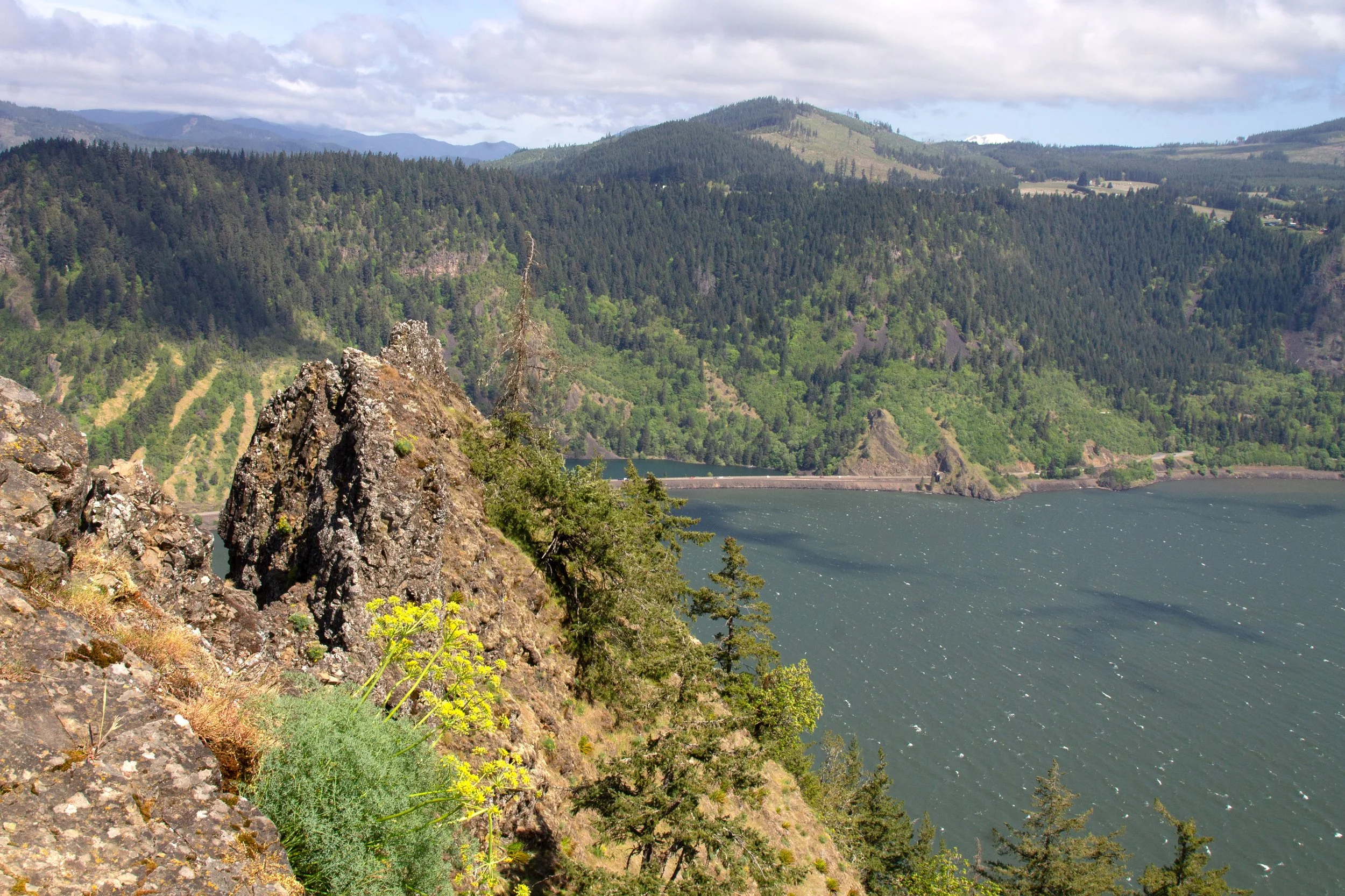
Top of Mitchell Point
If you’re hiking in spring, look (carefully) down the east side of Mitchell Point to see an unlikely dogwood tree blooming.

Dogwood tree growing from…the air?
When you’ve had enough time with the views, head back down the way you came.
Getting there
From Portland, take I-84 to Exit 58 for Mitchell Point. The parking lot is just off the highway. To head back to town, you’ll have to drive a few miles east and backtrack. The drive from Portland to Mitchell Point takes about 50 minutes.
Enjoy your trip to Mitchell Point!
With love,
Emma
Explore nearby

See the Columbia Gorge’s other awesome tunnels, the Mosier Twin Tunnels.

Try out the short hike to the Starvation Creek Waterfalls.

Find the best things to do in Hood River.