

Proxy Falls Hike


The Proxy Falls Loop is an easy and rewarding trail to two incredible waterfalls. It’s been on my hiking wish list for, I kid you not, about eight years. After seeing so many gorgeous photos and videos of Proxy Falls and Upper Proxy Falls, I was worried that visiting them would be a letdown. It wasn’t. Waterfalls are always better in person. Proxy Falls looks like something from another world, an enchanted and moss-covered realm where fairies dwell. Upper Proxy Falls tumbles around large rocks and trees into a mysterious disappearing pool. Along the way are chunky lava rocks, towering Doug firs, and wild rhododendrons. Here’s everything you need to know about the Proxy Falls Trail.

Proxy Falls
Know before you go
To park at the Proxy Falls Trailhead, you need a Northwest Forest Pass ($5/day) or an America the Beautiful Pass. Parking is limited and can be crowded on summer weekends.
The road to the trailhead is closed most of the year. Mid-June through October are usually safe bets to find it open. After the road closes, you can park at the snow gate and hike (or snowshoe) an extra 5 miles round-trip to reach the trailhead.
Leashed dogs are welcome on the trail to Proxy Falls.
The trailhead has restrooms and a picnic table.
The main trail is easy and family-friendly. The optional spur to the base of Lower Proxy Falls is steep with some rough terrain and a log crossing.

Base of Proxy Falls
On the trail to Proxy Falls
Distance: 1.6-mile loop
Elevation gain: 150 feet
Difficulty: Moderate
Pass required: NW Forest Pass or America the Beautiful Pass
Dog friendly: Yes, leashed dogs are welcome on the trail.
ADA access: No
Season: Summer and early fall
The details
The Proxy Falls Trailhead is hard to spot until you get close. It’s across the road from the restroom building and next to the large sign with the map and regulations. The loop hike starts and ends here. We’ll head to the right of the sign to do the loop counterclockwise.

Start here
The hike begins in the forest next to the road. After passing under tall Doug firs, the trail weaves through a field of lava rock, the legacy of a nearby eruption around 1,500 years ago. Vine maples growing from the boulders showed the first hints of orange in mid-July, a pretty but horrifying sight for those of us who live for summer. Expect great color in the fall. Behind you are the cliffs of Deer Butte.

Lava rock field
After passing through the lava rock field, the trail reenters the forest. Rhododendrons and bear grass fill the understory. Almost all the blooms were gone by my mid-July hike, but fallen pink petals on the trail told me I didn’t miss them by much. I’d love to come back another year as soon as the road to the trailhead opens to see them in their glory. A few pipsissewa blossoms were what remained by mid-summer.

Forest on the Proxy Falls Loop
After about 0.7 miles, you’ll reach a junction marked with a sign. Go right towards Lower Proxy Falls.

Take a right toward Lower Proxy Falls
You’ll see Lower Proxy Falls, officially called Proxy Falls, from a distance as soon as you start the spur trail. A gap in the trees provides a good view of most of the waterfall’s height. To avoid the hike’s most difficult terrain, turn around here and continue the loop.

The easy-to-reach viewpoint for Proxy Falls
To see the falls up close, continue down the hill. It’s a steep descent on an unmaintained trail. I’d say the scramble is worth it, but I enjoy questionable terrain and have a benign if semi-neurotic obsession with pictures. If you decide to head down the hill, cross the creek using the large fallen tree. On the other side, you’ll start seeing the mist from Proxy Falls.

Cross this log
The base of Proxy Falls is the best place to appreciate its spectacular scale. The 225-foot waterfall is misty and ethereal, tumbling in streams and trickling down countless rivulets over a cliff that glaciers formed. It makes a broad fan shape down the mossy cliff before flowing out as a cascading creek. The water is as clear as glass, making it easy to see the cobbles of the creek bed. Moss grows on every surface above the water level.
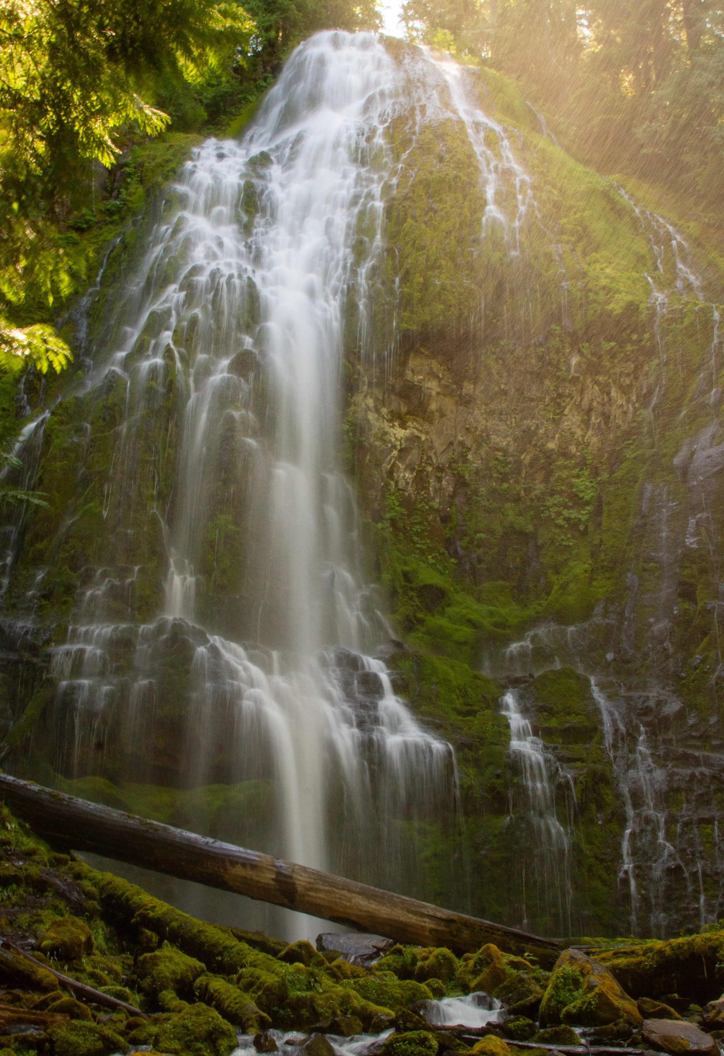
Proxy Falls
Take some time to admire Proxy Falls, then head back over the log bridge and up the hill. When you’re back at the trail junction, keep right to continue the loop.

Base of Proxy Falls
About a mile into the loop is another short spur, this one ending at Upper Proxy Falls. Unlike Proxy Falls, it’s easy to approach without a scramble. The 130-foot waterfall is one you need to see in person to appreciate. I have a photo for form’s sake, but I don’t feel great about it. Between midday sunlight and the trees, logs, and rocks obscuring the waterfall, it’s a hint at best. In person, Upper Proxy Falls doesn’t have quite the same wow factor as Proxy Falls, but it’s a lovely and impressive sight.

Upper Proxy Falls
The great curiosity of Upper Proxy Falls is that it doesn’t appear to have an outlet. After tumbling down into a pool, the water doesn’t flow out as a creek or rise with time. Instead, it trickles down through porous volcanic rock and continues underground, giving it a kind of infinity pool effect.

Base of Upper Proxy Falls
After seeing Upper Proxy Falls, head back to the loop and finish the last half mile. You’ll soon leave the forest and pass through the lava rocks again before returning to your starting point.

End of the loop
Enjoy your hike on the Proxy Falls Trail!
With love,
Emma
Getting there
The Proxy Falls Trailhead is off OR-242, which closes for about half the year. When the road is open, park along the shoulder near the trailhead. The trail starts across the road from the restroom building. The drive from Portland takes 3-3.5 hours. The closest town is Sisters, Oregon, about an hour away.
Explore nearby

Hike to the Tamolitch Blue Pool.

See incredible Cascade Mountain views on top of Black Butte.

Find the best things to do in Sisters, Oregon.