

20+ Columbia Gorge Waterfalls, Ranked

As I was looking for my next Columbia Gorge waterfall hike, I realized that I may have been to…all of them? At least, the ones within a fairly laid-back hiking distance. I know I’m missing something, but it was surprisingly hard to confirm. I looked through several guidebooks and many more websites. I didn’t find a nice, succinct list of Columbia Gorge waterfalls on public land. So, here’s my attempt. I ordered it according to how cool I find the waterfalls. It’s completely subjective, and feel free to scoff at my taste. If I find more, I’ll add them.
Emerald Falls (#14)
The list
What’s on the list:
Waterfalls close to I-84 (Oregon) or Highway 14 (Washington) in the Columbia Gorge.
Waterfalls you can see at viewpoints or on day hikes, mostly within about 8 miles of distance.
All the trails and viewpoints allow leashed dogs. The only one I wouldn’t recommend with a dog is the Eagle Creek Trail (#7) because of safety concerns.
Not on the list:
Waterfalls without legal public access, like Spirit Falls.
Waterfalls that involve a significant detour from the Columbia River, like Falls Creek Falls, the Lewis River waterfalls, or Dougan Falls.
Seasonal waterfalls
Backpacking or bushwhacking
Columbia Gorge Waterfalls
1. Multnomah Falls
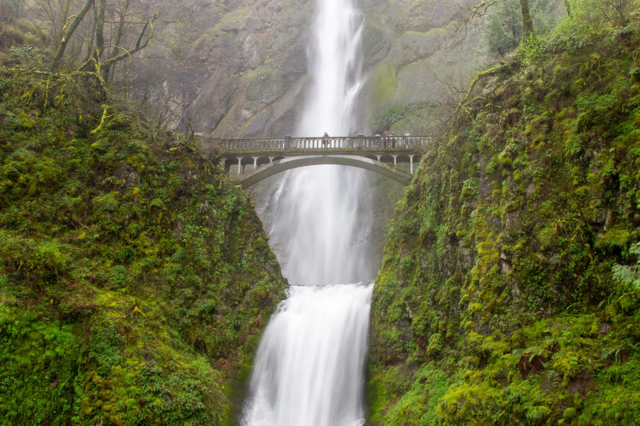
Multnomah Falls
Hiking: Optional
Pass required: A timed reservation permit is required seasonally. Learn more here.
ADA access: Sidewalks without a steep grade lead to the base of the falls. Beyond it, you’ll need to go up steps. Accessible parking and restrooms.
Drive time from Portland: 30 minutes
The waterfall: Multnomah Falls may be a predictable first choice, but I wouldn’t call it overrated. It’s famous because it’s awesome, and the only complaints I’ve heard are about the crowds, not the scenery. Two slightly offset tiers make a 620-foot plunge down a craggy basalt cliff. A beautiful stone arched bridge, Benson Bridge, passes in front of the upper tier at just the place that’s most pleasing to the eye.
How to see it: The best views are from the base of Multnomah Falls, no hiking needed, but I’ve never been able to resist going farther. Less than a half mile on an easy paved trail will get you to Benson Bridge. In winter, prepare to get soaked with clouds of mist as you cross. In summer, it’s more sedate. If you make the tiring climb up the 11 switchbacks, you’ll get to the top of the falls, where you can peer down at the little speck people below. It’s about a mile to the top.
2. Latourell Falls (and Upper Latourell Falls)
Latourell Falls
Hiking: Optional
Pass required: Oregon State Park Pass
ADA access: Not really. You can see a partial view of Latourell Falls from the parking lot.
Drive time from Portland: 35 minutes
The waterfalls: Latourell Falls is an impressive 224 feet tall, but it’s the picture-perfect, straight-as-an-arrow plunge that makes it special. Without brush or tree branches blocking the view, it’s as well framed as a theater set. Behind the waterfall is an eye-catching basalt cliff covered with patches of neon yellow-green lichen. Toward the bottom of the cliff are hexagonal columns that formed when lava cooled millions of years ago.
If you’re up for a hike, the 120-foot Upper Latourell Falls is a rewarding destination. The waterfall’s two tiers fall at an angle that makes it hard to see the full height at once. The lower tier flows over a moss-covered ridge in front of impressive recessed columns.
How to see it:
The easiest way to see Latourell Falls is to take the stairs from the parking lot. A viewpoint is at the top, no hiking needed.
I highly recommend starting the trail at the west end of the parking lot. A quarter mile will bring you to an extraordinary viewpoint at the base of Latourell Falls.
If you have time and energy, it’s worth taking the 2.4-mile loop trail to Upper Latourell Falls.
Learn more about visiting Latourell Falls.
3. Hardy Falls, Rodney Falls, and Pool of the Winds
Rodney Falls
Hiking: 2.5 miles out and back
Difficulty: Easy
Pass required: Washington Discover Pass
ADA access: No
Drive time from Portland: 50 minutes
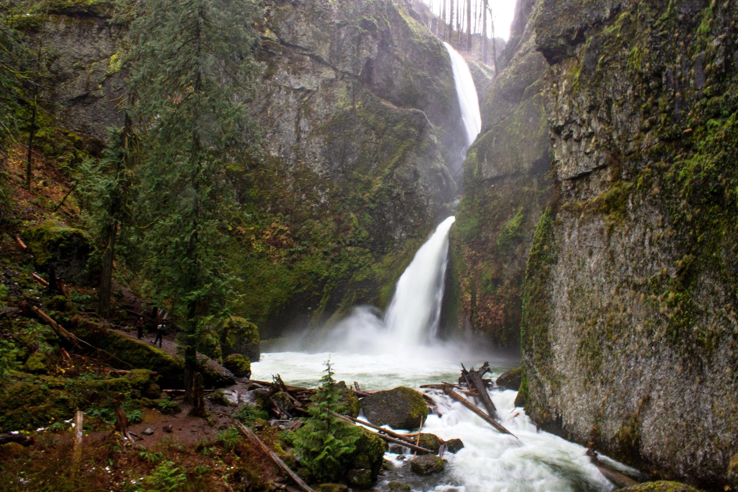
The waterfalls: Oregon has taller and steeper slopes in the Columbia Gorge than Washington, which means most of the truly jaw-dropping waterfalls are south of the river. Beacon Rock State Park is an exception. Taken together, three waterfalls along Hardy Creek are some of the most spectacular in the Gorge. First, you see the 90-foot single plunge of Hardy Falls. Just ahead is a curved footbridge in front of Rodney Falls, cascading over jagged and angular rocks. Finally is the curious Pool of the Winds, a 20-foot vertical chute in a hollowed-out cylinder.
How to see it: Take the Hamilton Mountain Trail in Beacon Rock State Park. A family-friendly 2.5-mile hike leads to the waterfalls. Beyond them, you can continue up Hamilton Mountain for a more challenging day. Past the waterfalls, the trail gets close to steep drop-offs and isn’t a good destination with younger kids.
Learn more about hiking to the Hardy Creek waterfalls and Hamilton Mountain.
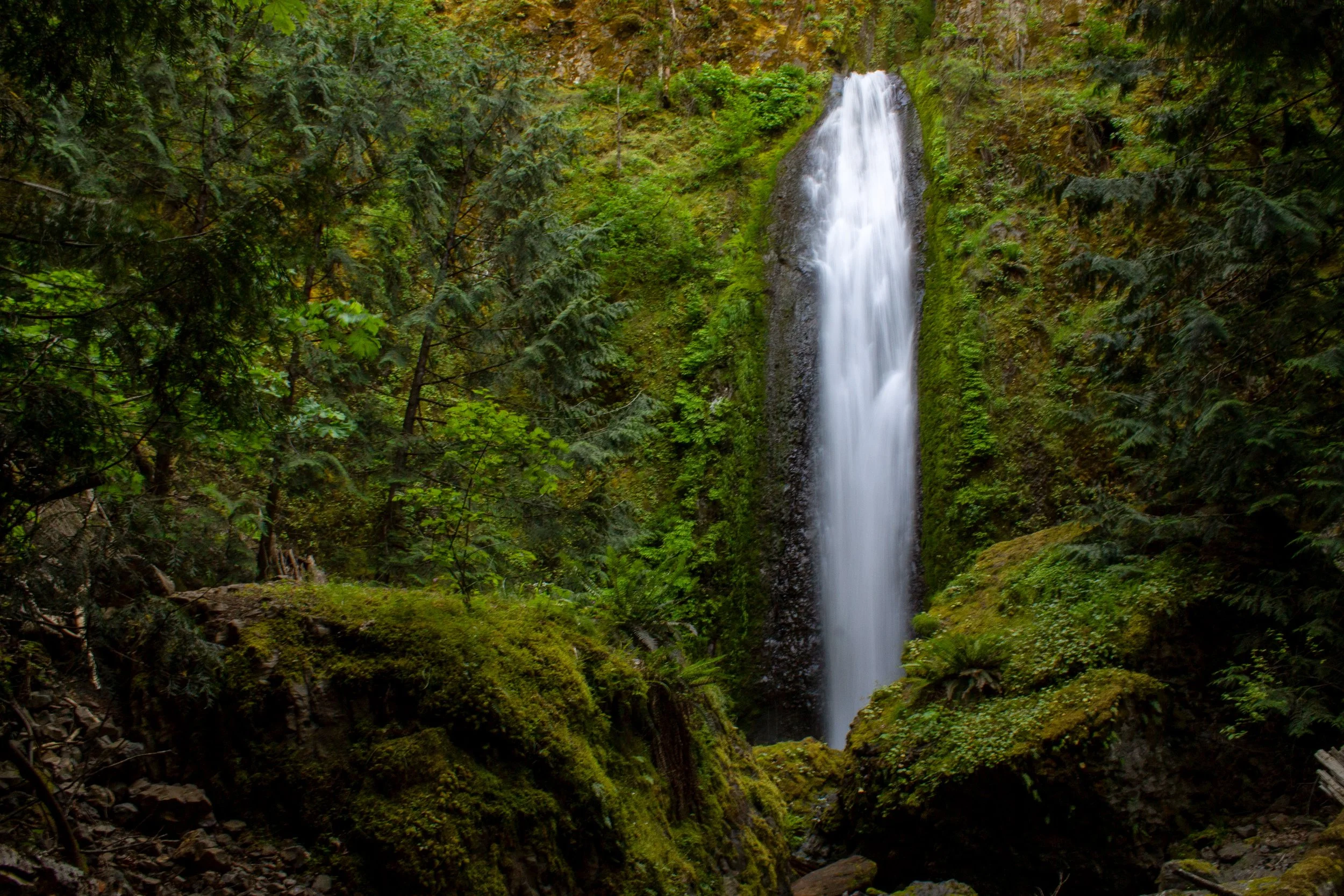
4. Wahclella Falls
Wahclella Falls
Hiking: 2.4-mile lollipop loop
Difficulty: Easy
Pass required: NW Forest Pass or America the Beautiful Pass. An overflow parking lot has free parking.
ADA access: No
Drive time from Portland: 40 minutes
The waterfall: At 350 feet, Wahclella Falls is one of the taller waterfalls in the Columbia Gorge. Yet, it’s the power rather than the height that makes it memorable. When many waterfalls start to look like dripping faucets in late summer, Wahclella Falls still roars. The sharply angled drop of the two-tiered waterfall is unusual, making it hard to see the upper tier unless you’re in just the right spot. It tumbles down a slot canyon before surging out as a 60-foot lower tier. Enormous mossy boulders beneath the waterfall add to its grandeur. Wintertime brings a bonus of smaller seasonal waterfalls on the way there.
How to see it: An easy hiking trail follows Tanner Creek through a dramatic canyon, ending at Wahclella Falls. A section of the trail runs alongside a steep slope. I’d still call it kid-friendly. If you’re afraid of heights, you might dislike this hike.
Learn more about visiting Wahclella Falls.
5. Bridal Veil Falls
Bridal Veil Falls
Hiking: 0.6 miles out and back
Difficulty: Easy
Pass required: Oregon State Park Pass
ADA access: No
Drive time from Portland: 30 minutes
The waterfall: I think of Bridal Veil Falls as the unsung hero of the Waterfall Corridor, the area of the Columbia Gorge right around Multnomah Falls. When the parking lots at Angel’s Rest are a circus, chances are you can still find a spot at Bridal Veil, where a short and sweet trail leads to a stunning finale. The two-tiered, 120-foot waterfall is more about understated beauty than raw power. It flows down a moss and fern-covered cliff into a picturesque pool where people wade in the summer. Enough water passes over it to keep it looking impressive throughout the year.
How to see it: The trail to Bridal Veil Falls is over before you know it, just far enough to be able to say that you went for a hike. It’s a little over a quarter mile from the parking lot, and a great destination to tempt your non-hiking friends into the woods. After seeing the waterfall, it’s worth checking out a separate half-mile loop trail that brings you to viewpoints overlooking the Columbia Gorge.
Learn more about visiting Bridal Veil Falls.
6. Horsetail Falls and Ponytail Falls
Horsetail Falls
Hiking: Optional
Pass required: None
ADA access: Horsetail Falls has accessible parking and a viewpoint. The trail to Ponytail Falls is steep and uneven.
Drive time from Portland: 40 minutes
The waterfalls: Horsetail Falls is one of the magical sights along the Historic Columbia River Highway that make you wonder what enchanted place you’ve stumbled upon. The 176-foot sidewinding waterfall slides down a mossy cliff into a pool framed by an elegant stone wall.
Stop here or continue on a short trail to Ponytail Falls. This 80-foot waterfall is essentially an upper tier of Horsetail Falls, set back too far to be visible from the road. The cliff behind the falls has eroded enough to allow the trail to pass behind it.
How to see it: Horsetail Falls is so close to the road that the mist might cover your car during wetter months. Park across the street and admire it from the viewpoint. The trail next to Horsetail Falls climbs 0.4 miles to Ponytail Falls. It’s short but steep, a good noncommittal hiking distance with a rewarding destination. For a longer hike, consider continuing to Triple Falls (#12).
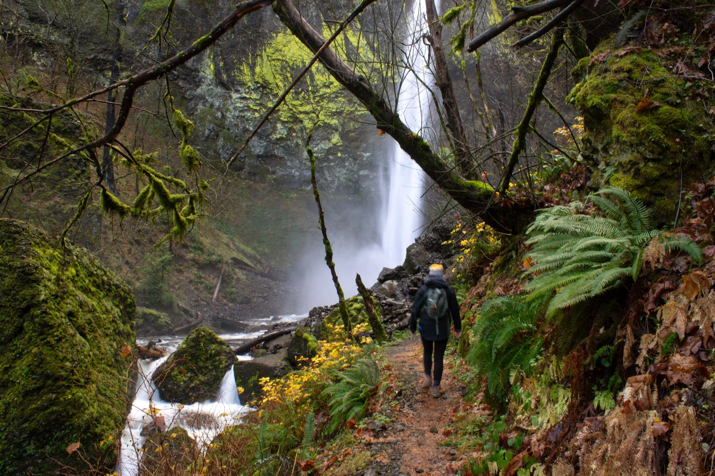
7. Eagle Creek waterfalls
Punch Bowl Falls
Hiking: Up to 12 miles out and back
Difficulty: Moderate to hard
Pass required: NW Forest Pass or America the Beautiful Pass
ADA access: No
Drive time from Portland: 45 minutes
The waterfalls: From late fall to early spring, the Eagle Creek Trail is a thrill ride of back-to-back waterfalls. Many are seasonal. A few of them look interesting all year, especially Punch Bowl Falls and Tunnel Falls. Short and squat Punch Bowl Falls has a satisfying amount of water flowing into a circular amphitheater. In the summer, the pool beneath it is a popular swimming hole. Farther along the trail, Tunnel Falls drops 172 feet straight down a fern-covered cliff. A manmade tunnel passes behind it.
How to see it: The Eagle Creek Trail is one of Oregon’s most astounding hikes. The trail runs through the Eagle Creek Canyon, at times shrinking to a narrow ledge along a cliff where cable rails line the way for safety. I like visiting at unpopular times, like rainy days. I have no fear of heights, but it can be stressful when crowded. I wouldn’t bring younger kids or dogs here. The trail has too many cliffs. Punch Bowl Falls is an approachable 4.5-mile hike. Tunnel Falls is an all-day 12-mile hike that I was lucky enough to do around 10 years ago, before my bike accident. In between are several other waterfalls that make good intermediate turn-around points.
8. Elowah Falls and Upper McCord Creek Falls
Elowah Falls
Hiking: Up to 3 miles in two spurs
Difficulty: Moderate
Pass required: None
ADA access: No
Drive time from Portland: 40 minutes
The waterfalls: If Mordor has waterfalls, I’m guessing they look a whole lot like Elowah Falls. The 213-foot waterfall shoots out as a single plunge into a basalt amphitheater decorated with patches of bright green lichen. Clouds of mist from the falls cover the piles of jagged rocks piled beneath it, making them look as shiny and dark as obsidian. A nearby trail heads to Upper McCord Creek Falls, a calmer 64-foot waterfall that tumbles over a broad ledge.
How to see it: Take the hiking trail from the John B Yeon Trailhead. The trail splits early on. The fork to the left takes you down to the bottom of Elowah Falls. The fork to the right leads to an overhead view of Elowah Falls, Columbia Gorge views, and Upper McCord Creek Falls. If you do both trails, it’s about 3 miles total.
Learn more about hiking at Elowah Falls.
9. Wahkeena Falls
Wahkeena Falls Viewpoint
Hiking: Optional
Pass required: None
ADA access: The lower Wahkeena Falls viewpoint has a ramp from the accessible parking lot.
Drive time from Portland: 35 minutes
The waterfall: Wahkeena Falls is a spectacular 242-foot waterfall. It would be higher on my Columbia Gorge waterfalls list if the undergrowth didn’t make it hard to see the whole thing at once. The scale is easiest to appreciate in the winter after the leaves drop. The top of the falls plunges over several tiers before cascading down the rest of the way to the lower viewpoint.
How to see it: The Wahkeena Falls Viewpoint is directly off the Historic Columbia River Highway. Parking is free but limited. The viewpoint is at the base of the falls. You can stop here or continue on the paved but steep trail to a pretty bridge across the upper tiers, about a mile round-trip. Past Wahkeena Falls, the trail continues to Fairy Falls (#16) and is part of the 5-mile Multnomah Falls - Wahkeena Falls Loop.
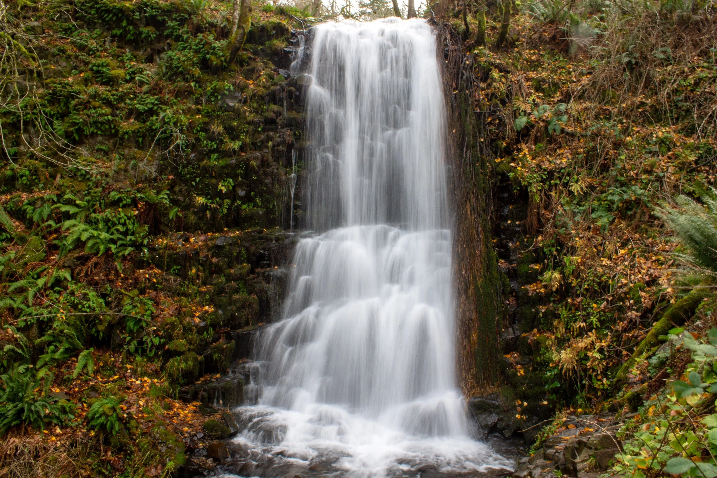
10. Wiesendanger Falls and friends
Wiesendanger Falls
Hiking: 3+ miles
Difficulty: Moderate
Pass required: A timed reservation permit is required seasonally to park at Multnomah Falls. Learn more here.
ADA access: No
Drive time from Portland: 30 minutes
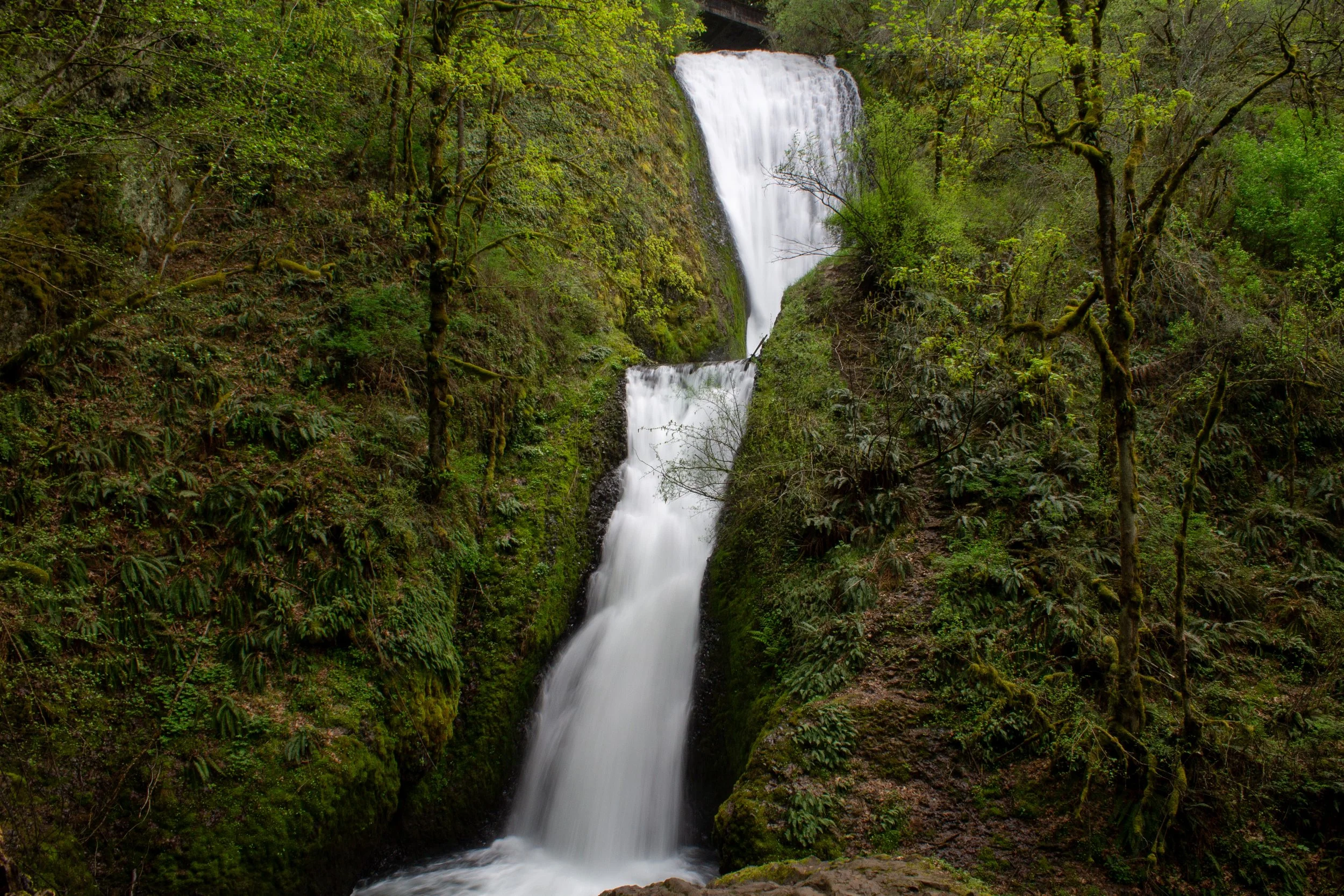
The waterfalls: Multnomah Creek passes over several waterfalls on the way to the grand finale at Multnomah Falls. I’m lumping them together in one entry because they’re all within about a quarter mile of each other. Making your way upstream, you’ll pass several short, cascading tiers of Dutchman Falls. Next is the 55-foot photogenic Wiesendanger Falls tumbling straight down the center of a curved amphitheater. Finally, the trail passes next to the top of Ecola Falls as it plunges over a 55-foot cliff.
How to see it: Start at Multnomah Falls and hike to the top of the falls. Then, take the Larch Mountain Trail along Multnomah Creek. You can turn around after seeing these waterfalls for a 3-mile out-and-back hike, or continue on the 5-mile Multnomah Falls - Wahkeena Falls Loop, which will add Fairy Falls (#16) and Wahkeena Falls (#9) to the journey. For a challenge, you can follow the Larch Mountain Trail to the summit of Larch Mountain, 14 miles round-trip, where a 360-degree panorama includes five major Cascade peaks.
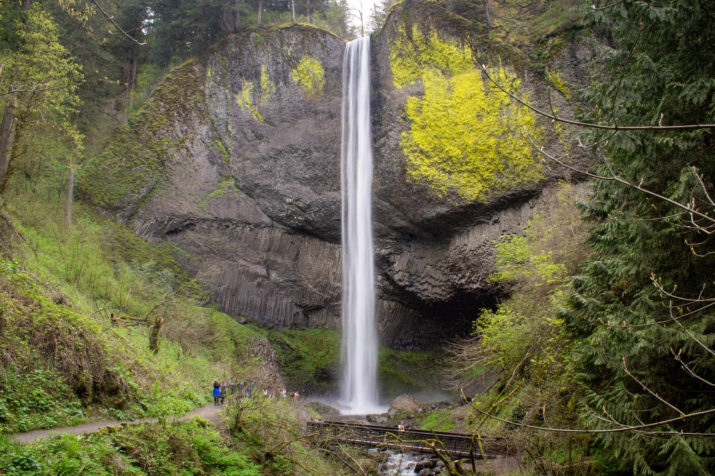
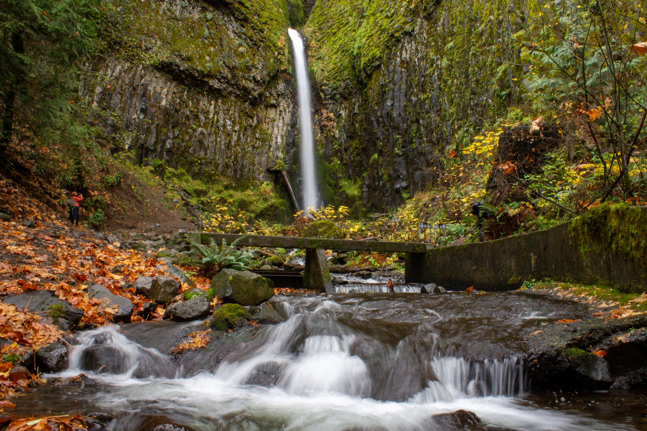
11. Starvation Creek Falls and friends
Starvation Creek Falls
Hiking: Optional
Pass required: Oregon State Park Pass
ADA access: The trail is wide and paved with minimal grade until Hole-in-the-Wall Falls. Accessible parking and restrooms.
Drive time from Portland: 50 minutes
The waterfalls: Starvation Creek Falls is an often-overlooked Columbia Gorge waterfall located near a rest stop off I-84. Beneath a short and hard-to-see upper tier, a tall and dramatic lower tier plunges over a craggy cliff behind large boulders. Three other waterfalls, Cabin Creek Falls (seasonal), Hole-in-the-Wall Falls, and Lancaster Falls, are nearby. All are worth seeing, at least in wetter months, but the 230-foot Starvation Creek Falls is the most impressive of the bunch.
How to see it: Starvation Creek Falls can be anything from a quick viewpoint stop to the beginning of the long and challenging trek up Mt Defiance. The waterfall is a few steps away from the parking lot. From here, you can follow the flat paved trail 0.5 miles to Cabin Creek Falls and Hole-in-the-Wall Falls. This part is doable with a bike, stroller, or wheelchair. Another half mile on a rougher unpaved trail will bring you to a tier of tall but mellow Lancaster Falls. The major catch of this otherwise great hike is that it’s next to I-84, and the road noise is a nuisance.
Learn more about the Starvation Creek waterfall hike.
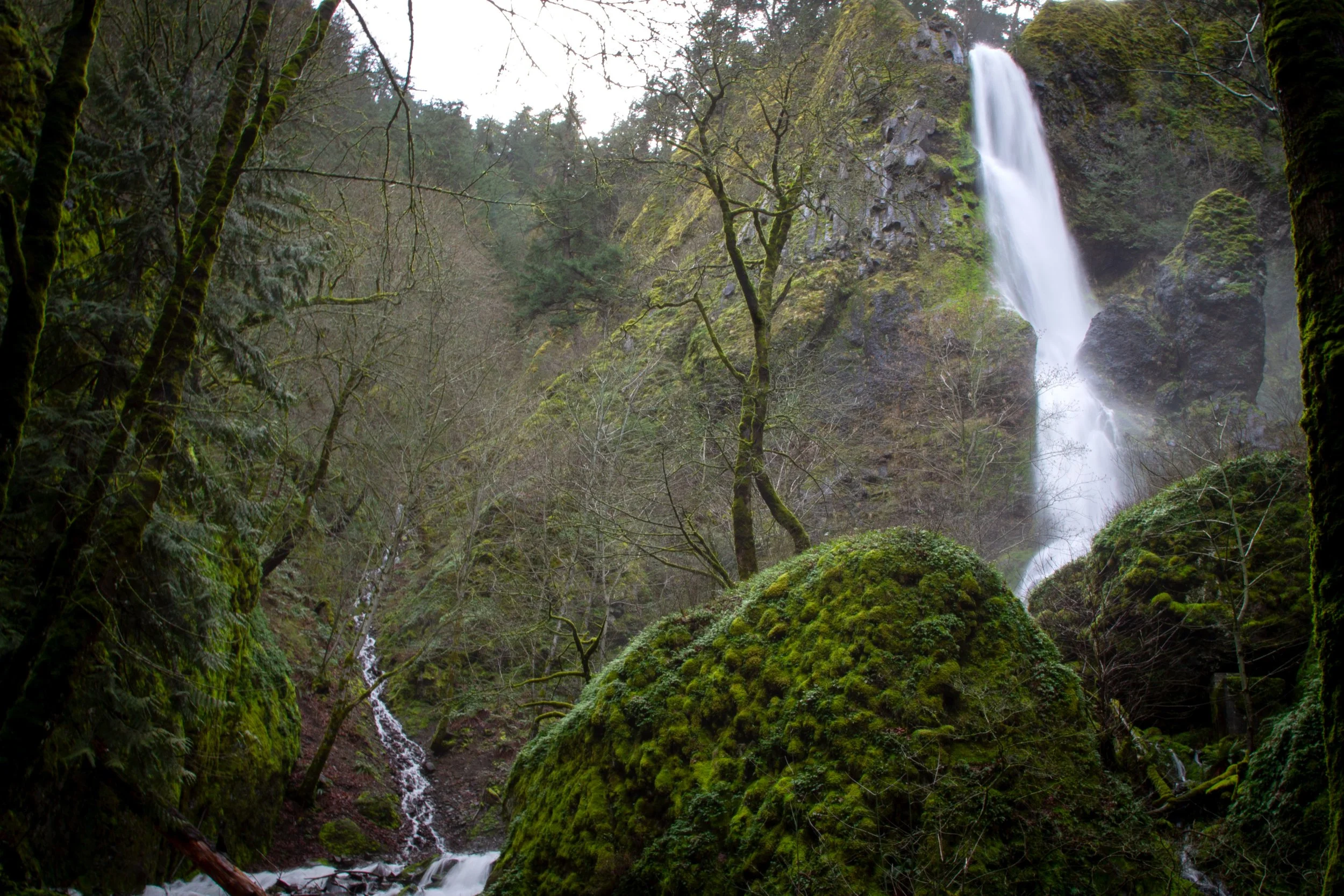
12. Triple Falls
Triple Falls
Hiking: 4.2 miles out and back
Difficulty: Moderate
Pass required: None
ADA access: No
Drive time from Portland: 40 minutes
The waterfall: Triple Falls is one of the most recognizable waterfalls in the Columbia Gorge because of its three distinct streams. While the 2017 Eagle Creek wildfire transformed the forest around it, the 85-foot waterfall looks just the same as it did before the burn.
How to see it: You can see Triple Falls from the Oneonta Trail. Most directions I’ve seen start from the Oneonta Trailhead, but I prefer hiking from Horsetail Falls, which brings you to more waterfalls for a similar amount of effort.
Learn more about the Triple Falls hike.
13. Shepperd’s Dell Falls
(Part of) Shepperd’s Dell Falls
Hiking: No
Pass required: None
ADA access: No. There’s no hike here, but stairs lead down to the viewpoint.
Drive time from Portland: 30 minutes
The waterfall: Shepperd’s Dell Falls is more interesting than my picture of it suggests. The 220-foot waterfall has a meandering course that makes it hard to fit in a single frame. It’s a waterfall you see in stages rather than with a single glance. Around it is a lush green forest and an arched bridge of the Historic Columbia River Highway.
How to see it: The Shepperd’s Dell Viewpoint is directly off the Historic Columbia River Highway. It has a sign, but it’s easy to miss because of the lack of a parking area. The small dirt pull-offs near the sign are where to stop. Once you’ve parked, take the stairs down to the viewpoint for the falls.
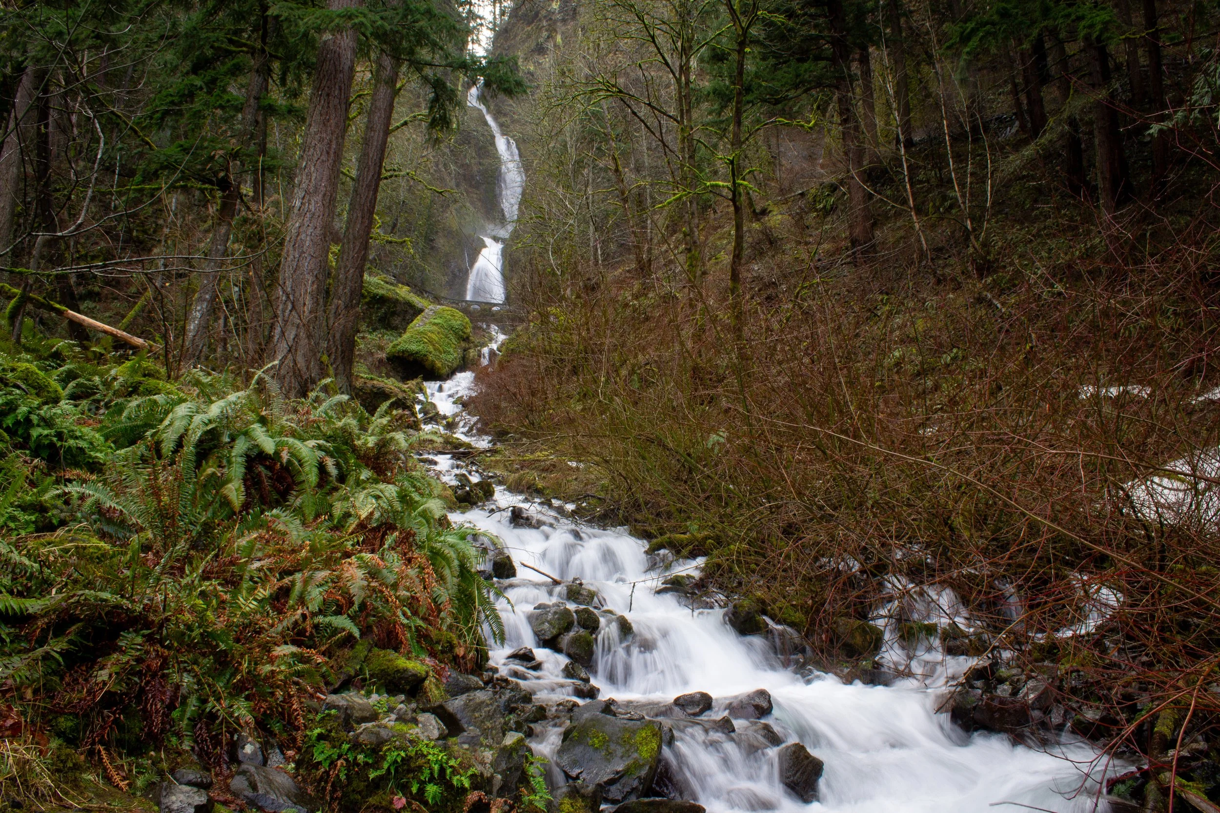
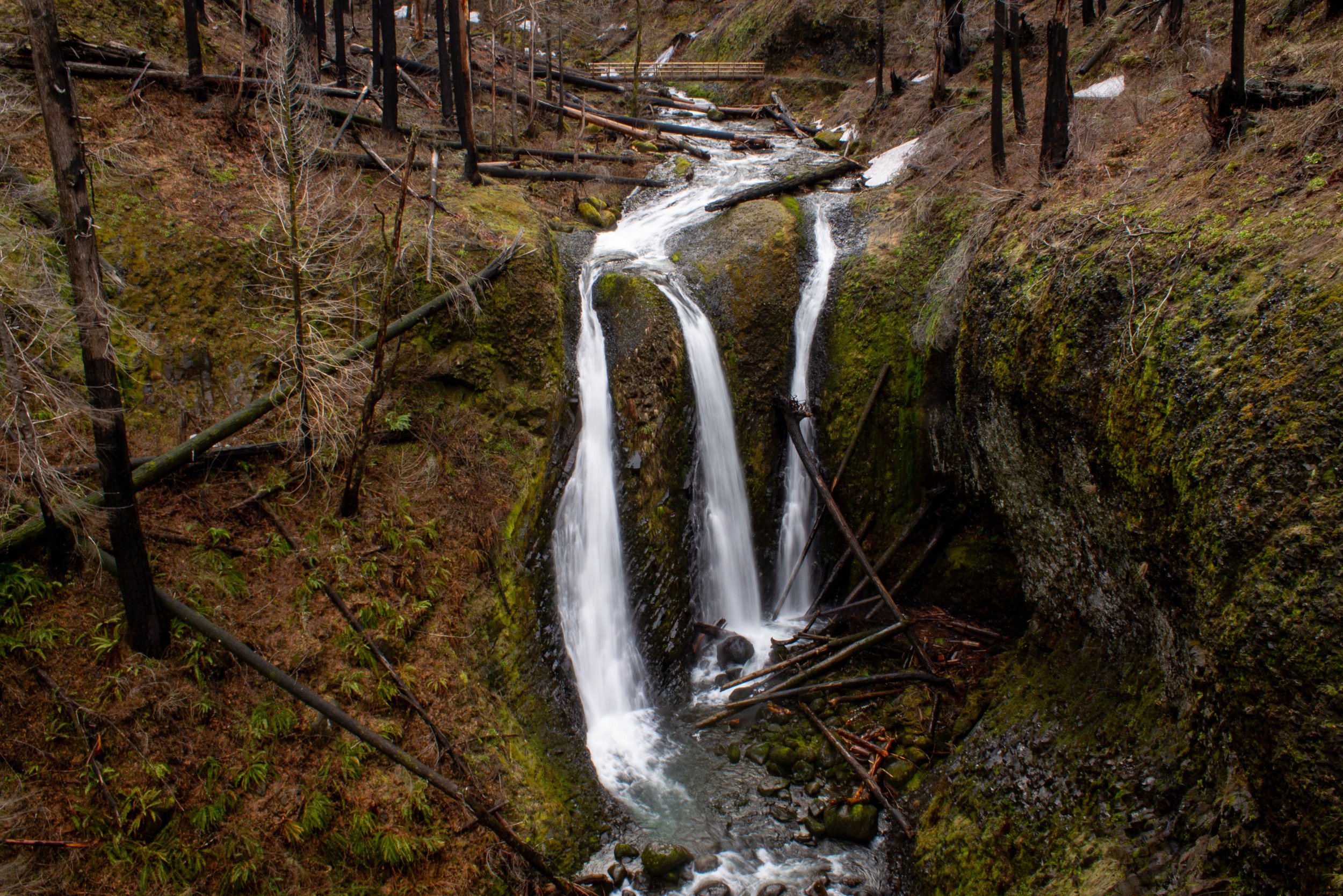
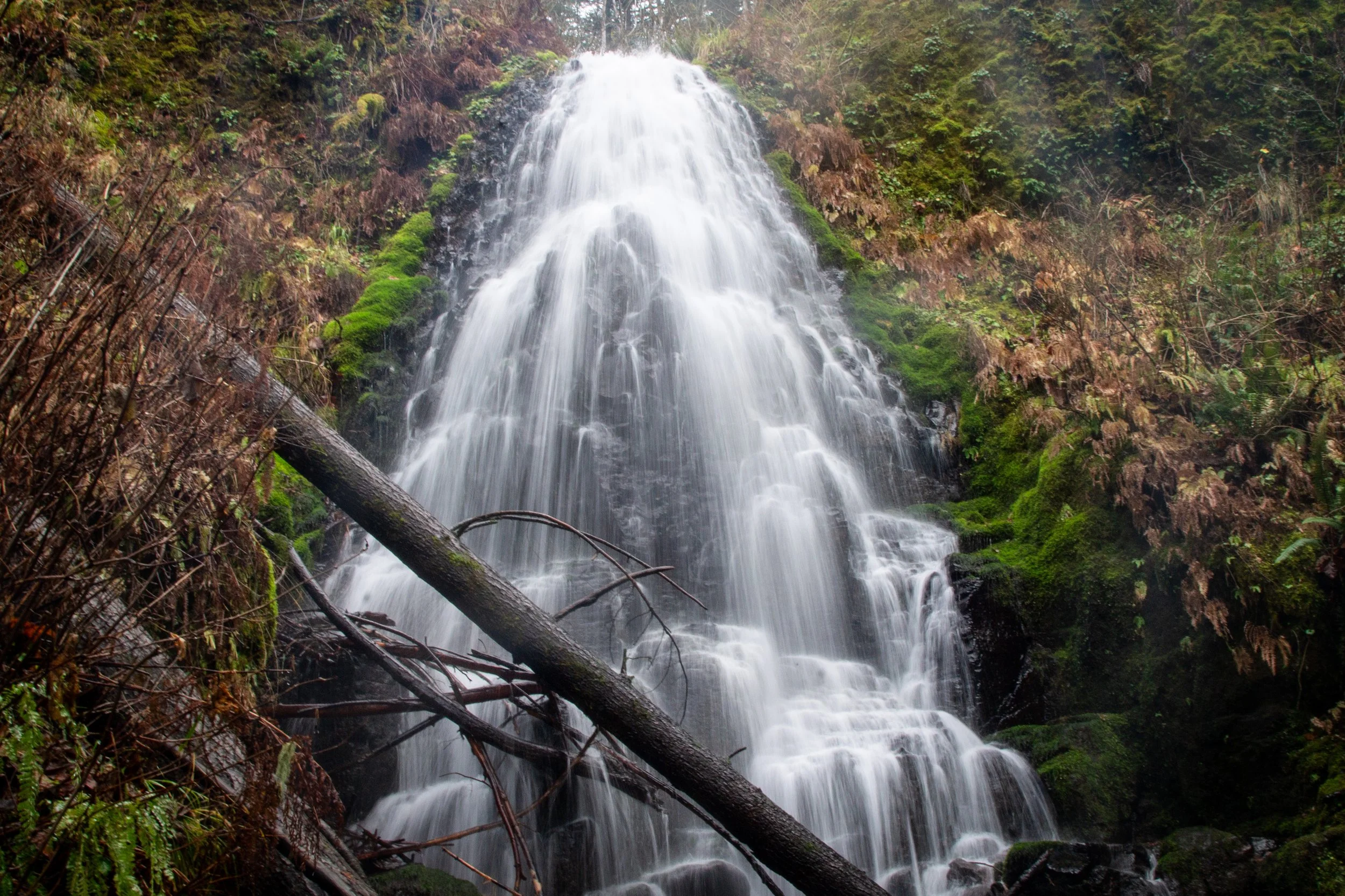
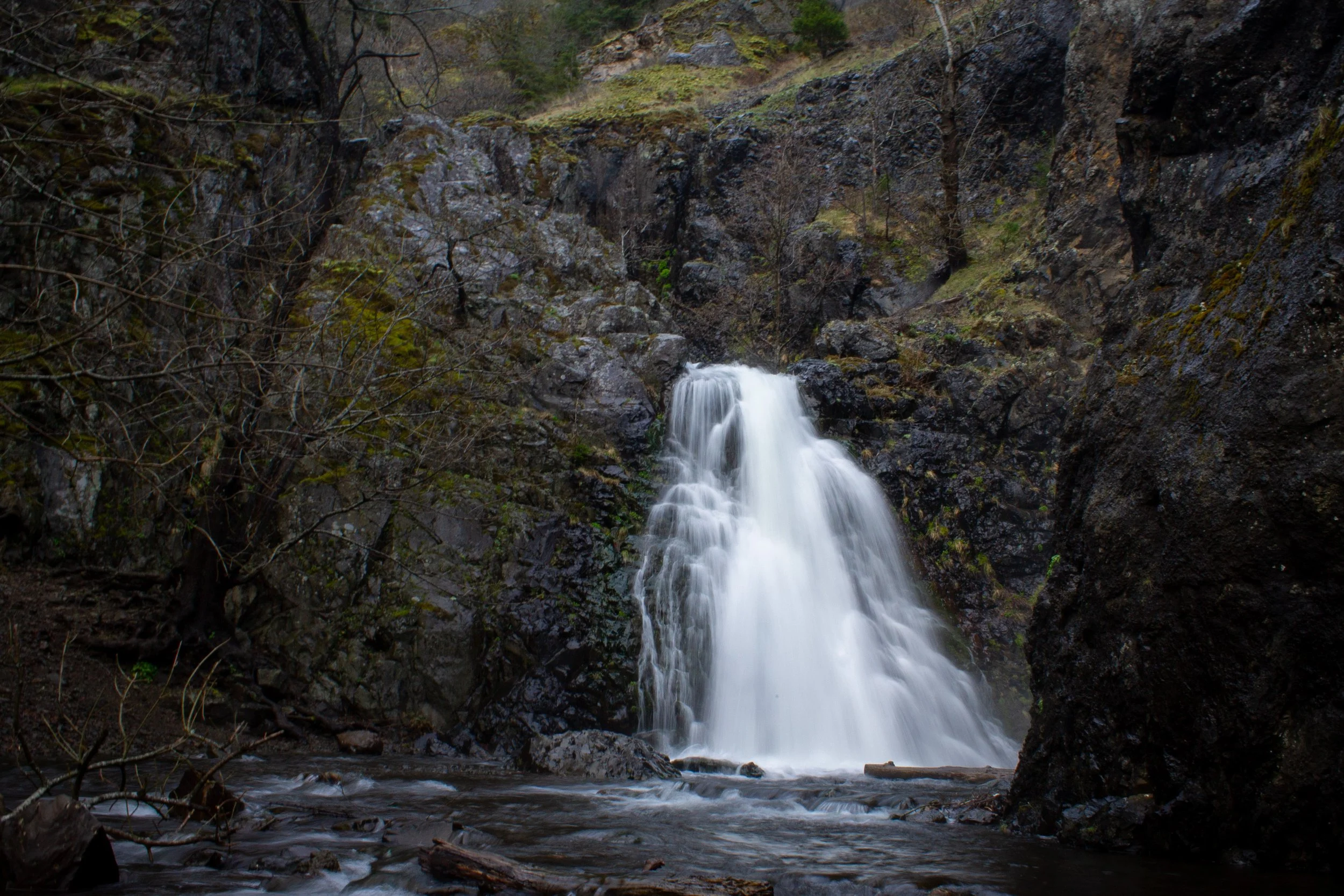
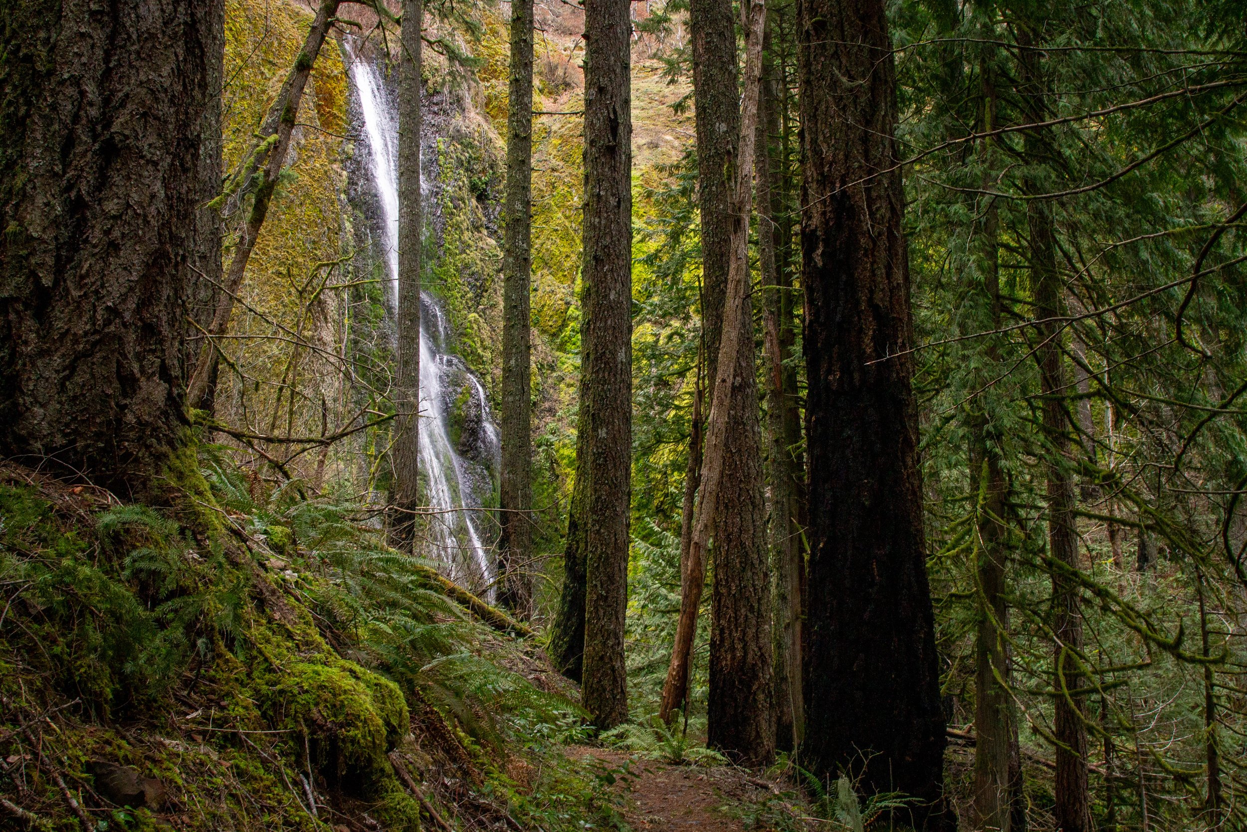
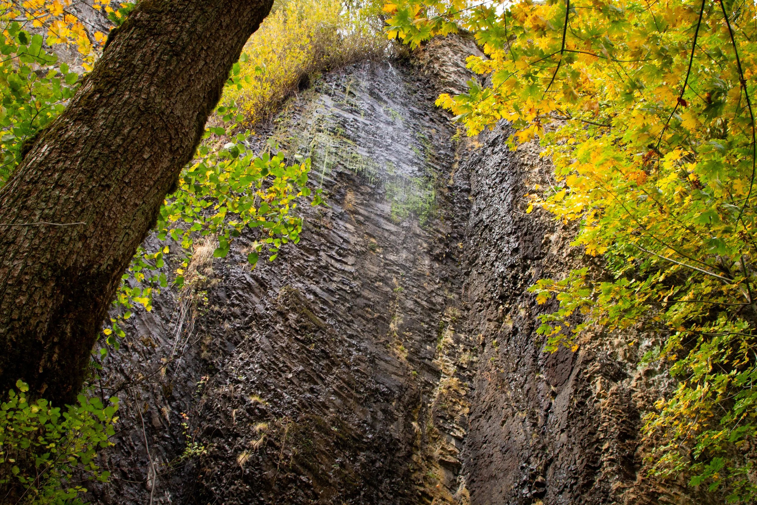
14. Emerald Falls and Gorton Creek Falls
Gorton Creek Falls
Hiking: 1.5 miles out and back
Difficulty: Easy (Emerald Falls) or Hard-ish (Gorton Creek Falls)
Pass required: NW Forest Pass or America the Beautiful Pass
ADA access: No
Drive time from Portland: 50 minutes
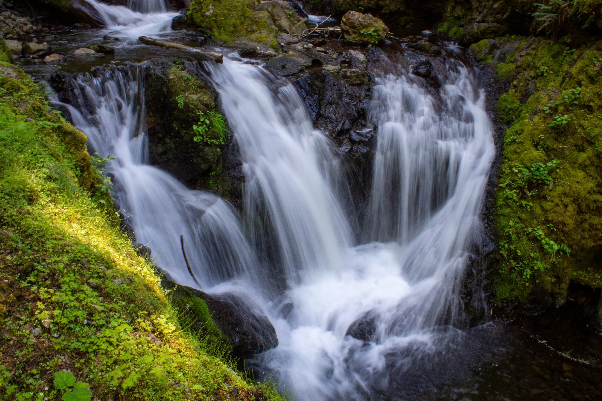
The waterfalls: Gorton Creek Falls is my vote for the most obscure waterfall hike in the Columbia Gorge. It’s a stunning two-tiered waterfall framed by some impressive basalt columns. Beneath the 115-foot falls, Gorton Creek flows out between huge moss and fern-covered boulders. The catch is that you need to continue about 0.1 miles past the end of the trail to reach it. On the way, you’ll pass the lovely, 10-foot Emerald Falls tumbling in three streams over a mossy ledge.
How to see it: Start at the Wyeth/Gorton Creek Trailhead. When you reach the trail junction, keep going straight onto the unlabeled trail. You’ll see Emerald Falls in less than a mile. If you stop here, the hike is easy, family-friendly, and doable all year. To see Gorton Creek Falls, you need to cross Gorton Creek and make your way upstream around the boulders and muddy banks. It’s best in summer and early fall when there’s less water in the creek.
Learn more about hiking to Emerald Falls and Gorton Creek Falls.
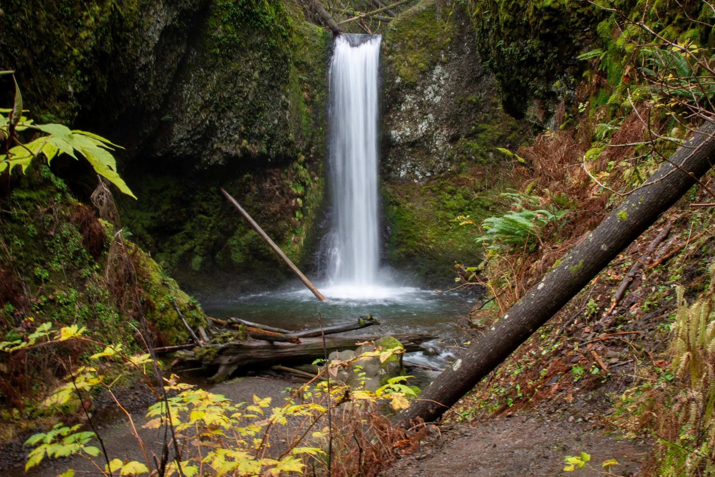
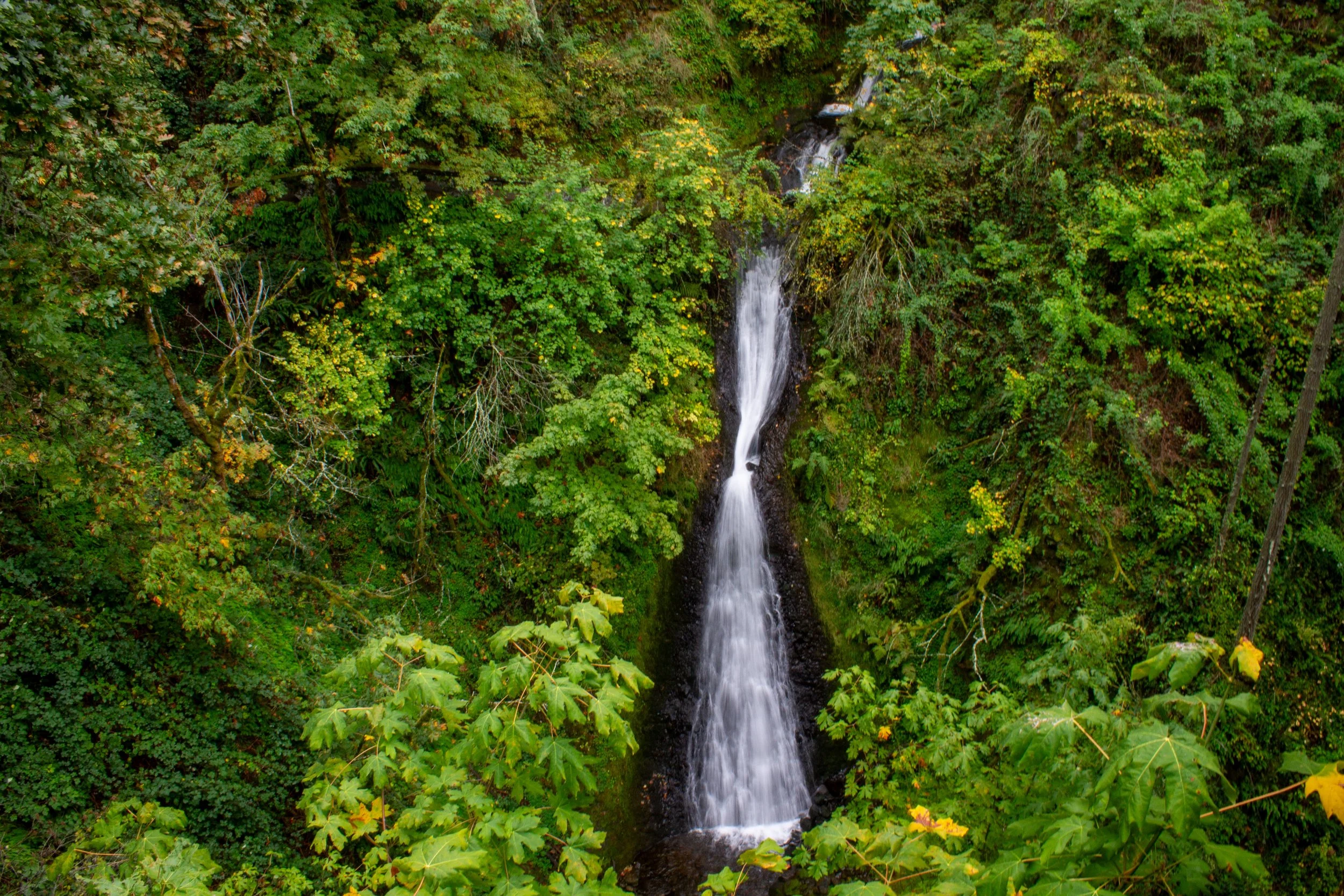
15. Dry Creek Falls
Dry Creek Falls
Hiking: 4.4 miles out and back
Difficulty: Easy
Pass required: Depends on where you park. The Bridge of the Gods lot requires the Northwest Forest Pass or America the Beautiful Pass. The lot on Harvey Rd is free.
ADA access: No
Drive time from Portland: 45 minutes
The waterfall: Dry Creek Falls shoots out over a basalt cliff like a spout. The part you can see is the 74-foot lowest tier of a taller waterfall. The other tiers are too far back in a narrow canyon to be visible. My favorite thing about Dry Creek Falls is the wall of basalt columns behind it. They formed millions of years ago, when a lava flow cooled and hardened into a hexagonal pattern.
How to see it: Dry Creek Falls is along the Pacific Crest Trail. Starting from Cascade Locks, an easy, family-friendly hike will get you there in just over two miles.
16. Fairy Falls
Fairy Falls
Hiking: 2+ miles
Difficulty: Moderate
Pass required: None
ADA access: No
Drive time from Portland: 35 minutes
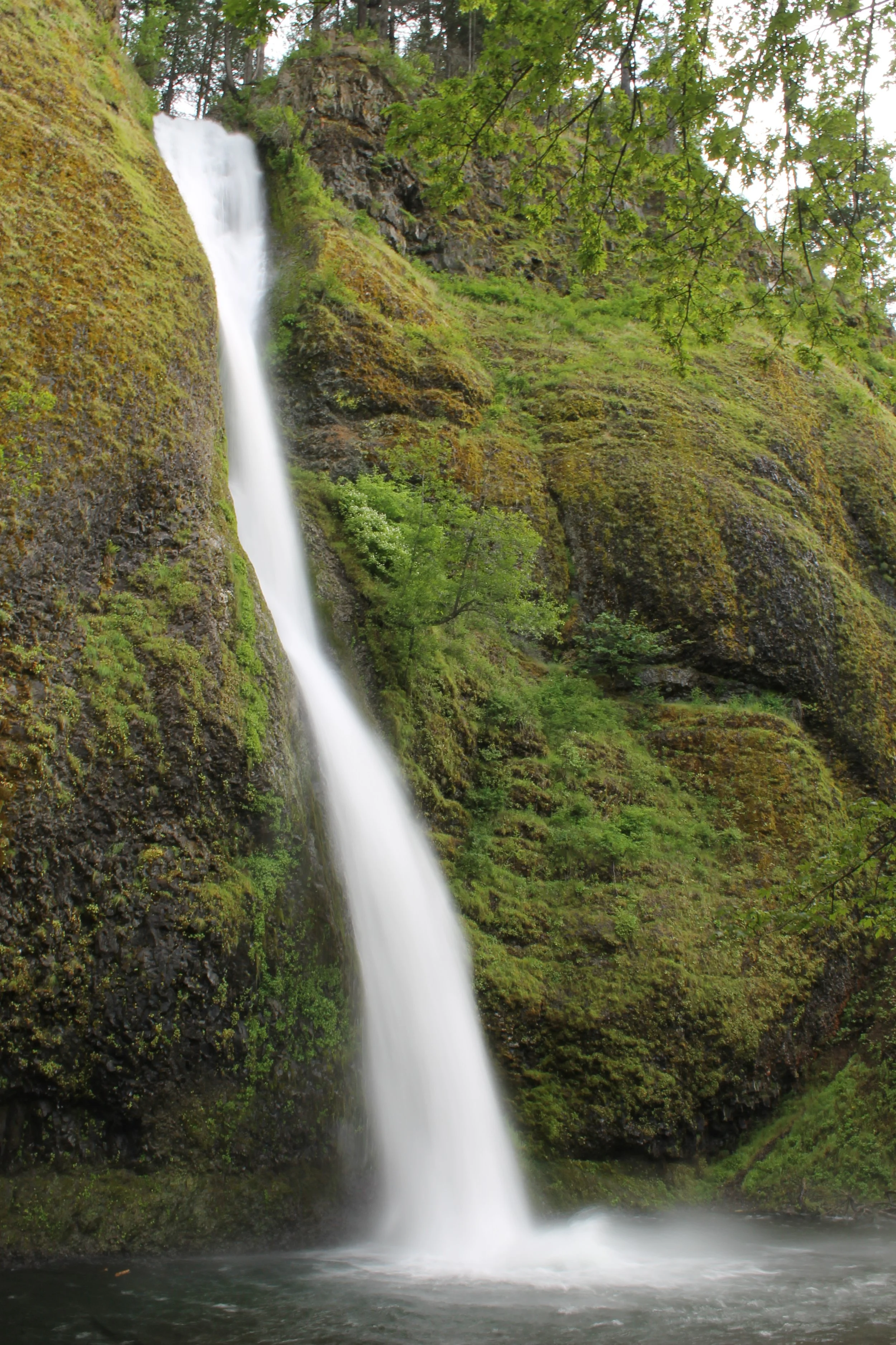
The waterfall: Fairy Falls has more charm than its 20-foot height would suggest. It’s so close to the Wahkeena Trail that you can reach out and touch it as you walk by. A veil of water fans out as it cascades down broken and chunky rock columns under a canopy of towering Doug firs.
How to see it: The most direct way to reach Fairy Falls is to take the Wahkeena Trail from Wahkeena Falls. You’ll see the upper tiers of Wahkeena Falls and an excellent Columbia Gorge vista from the Lemmons Viewpoint on your way. If you turn around here, it would be 2 miles out and back. Don’t be fooled by the short distance. There’s enough elevation gain to make it tiring. If you’re up for a longer hike, my favorite way to visit Fairy Falls is on the Multnomah Falls - Wahkeena Falls Loop.
17. Coopey Falls (and Upper Coopey Falls)
Upper Coopey Falls
Hiking: 1.5 miles (to Coopey Falls) or 4.8 miles (to Angel’s Rest) out and back
Difficulty: Moderate
Pass required: Oregon State Park Pass
ADA access: No
Drive time from Portland: 30 minutes
The waterfall: Coopey Falls is a lovely waterfall that tends to become an afterthought on the Angel’s Rest Trail, partly because it’s hard to see, and partly because the viewpoint at the end of the hike overshadows everything that came before. The 150-foot waterfall is set back in the trees. In summer, you have to use your imagination to get an idea of its height. In winter, it’s visible but far away. Just ahead on the trail, Upper Coopey Falls is shorter but more satisfying because you can get close to it.
How to see it: Arrive at some horrid time like 7 AM to get a parking spot. Take the Angel’s Rest Trail. You’ll reach a viewpoint for Coopey Falls in a little under a mile. Just past it, a short spur trail leads to Upper Coopey Falls. Then, check out the panoramic Columbia Gorge views on top of Angel’s Rest.
Learn more about hiking at Angel’s Rest.
18. Mosier Creek Falls
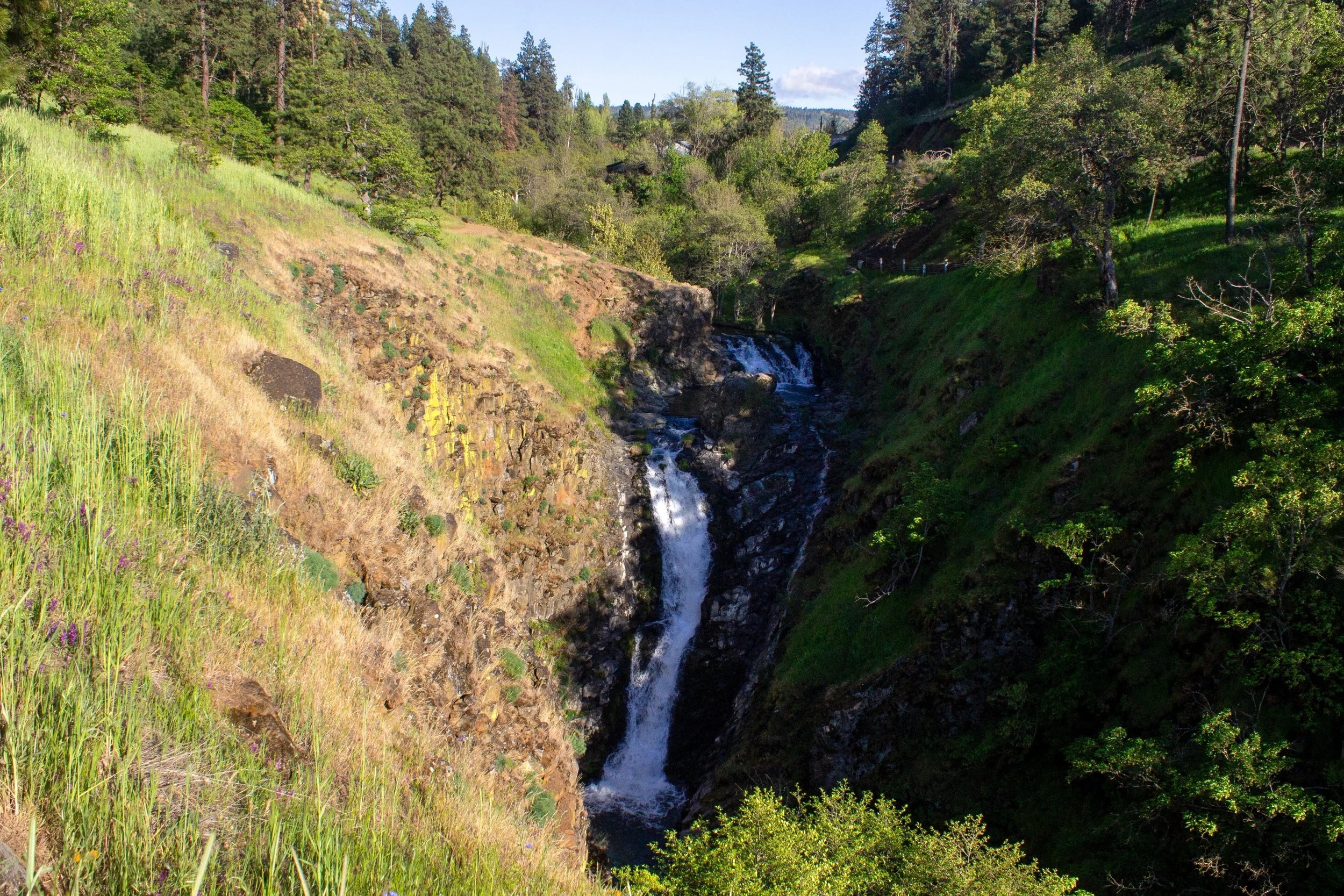
Mosier Creek Falls
Hiking: Up to a 3-mile lollipop loop (1 mile out and back to the falls)
Difficulty: Easy/moderate
Pass required: None
ADA access: No
Drive time from Portland: 70 minutes
The waterfall: Mosier Creek Falls is one of the few waterfalls east of Hood River in the Columbia Gorge. Stubby oak trees and open fields surround it rather than ferns and Doug firs. The 100-foot two-tiered waterfall sits back in a canyon with steep grassy slopes. The pool between the tiers is a popular swimming hole on hot days.
How to see it: Mosier Creek Falls is towards the beginning of the Mosier Plateau Trail. My favorite times to visit are spring and early summer when the wildflowers bloom.
19. Oneonta Creek waterfalls
Middle Oneonta Falls
Hiking: 4.2 miles out and back (on the Triple Falls hike)
Difficulty: Moderate
Pass required: None
ADA access: No
Drive time from Portland: 40 minutes
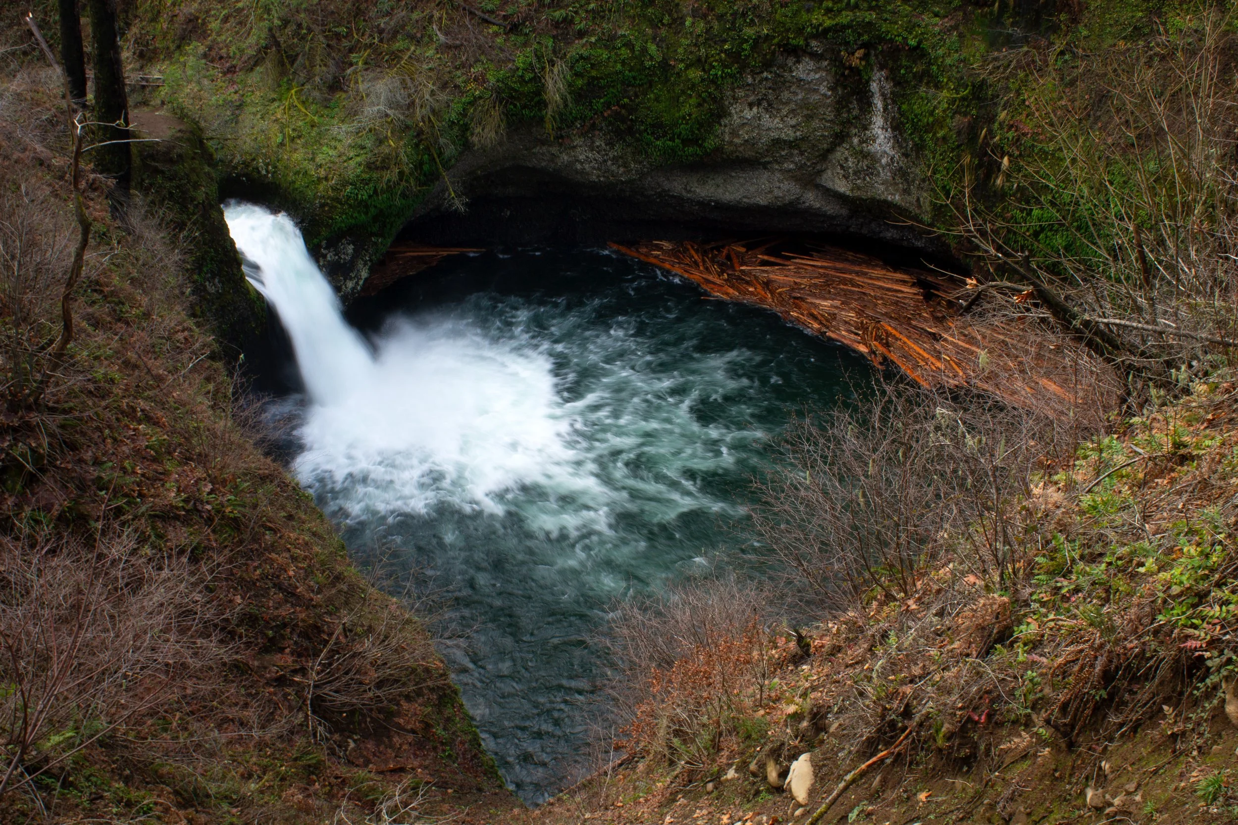
The waterfalls: Lower Oneonta Falls would be higher on my Columbia Gorge waterfalls list if the main hike to reach it weren’t closed indefinitely. As it is, you can get a partial view of it on the way to Triple Falls. Upstream, Middle Oneonta Falls is more satisfying, although only 20 feet tall.
How to see it: While the Oneonta Gorge is closed, the best way to see Lower and Middle Oneonta Falls is on the hike from Horsetail Falls to Triple Falls.
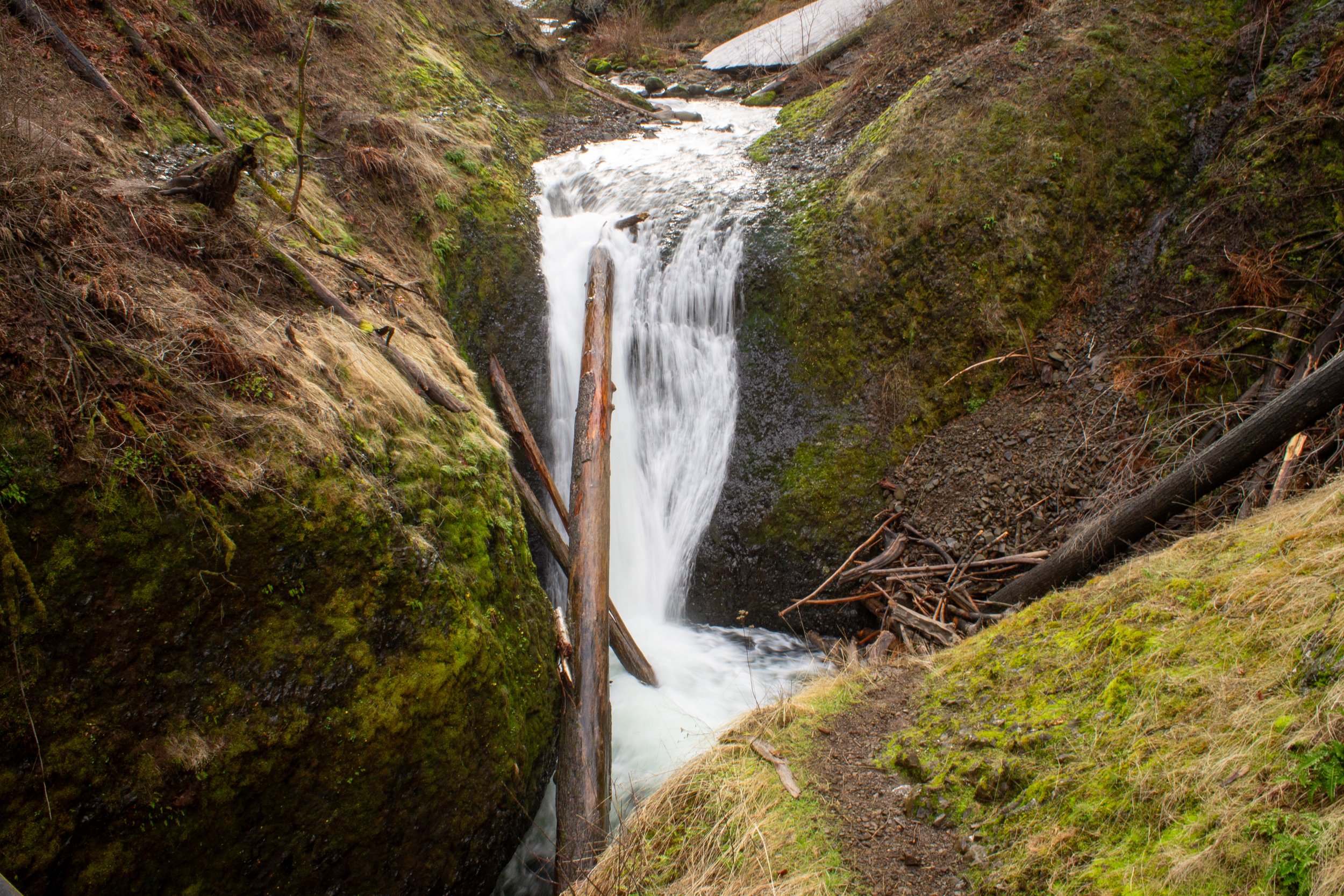
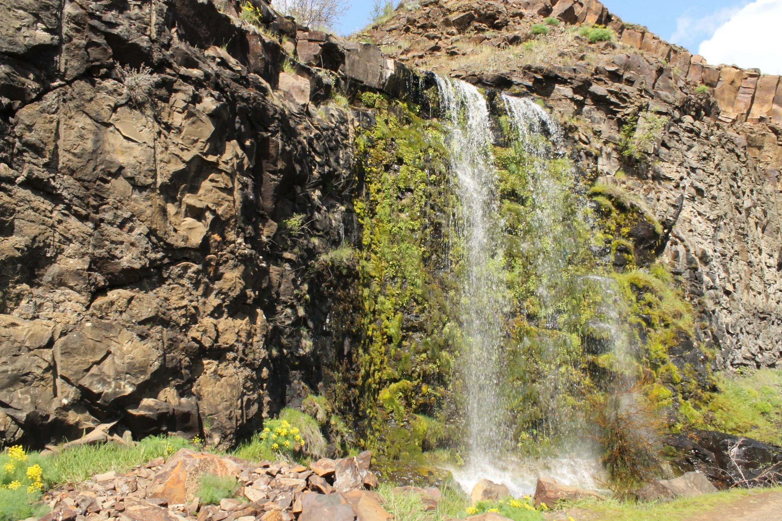
20. Dog Creek Falls
Dog Creek Falls
Hiking: No
Pass required: None
ADA access: No
Drive time from Portland: 65 minutes
The waterfall: I probably wouldn’t drive over an hour just to see Dog Creek Falls, but if you find yourself on the eastern side of the Washington Columbia Gorge, it’s a fun stop on the way back to Portland. The 30-foot waterfall cascades down a basalt cliff in a fan shape. Although very close to Highway 14, it’s tucked back in the woods just enough to feel secluded.
How to see it: From Highway 14, pull over into the easy-to-miss gravel lot next to the road. It’s much safer to stop when driving west. Follow the trail about 100 feet to reach Dog Creek Falls.
21. Catherine Creek Falls
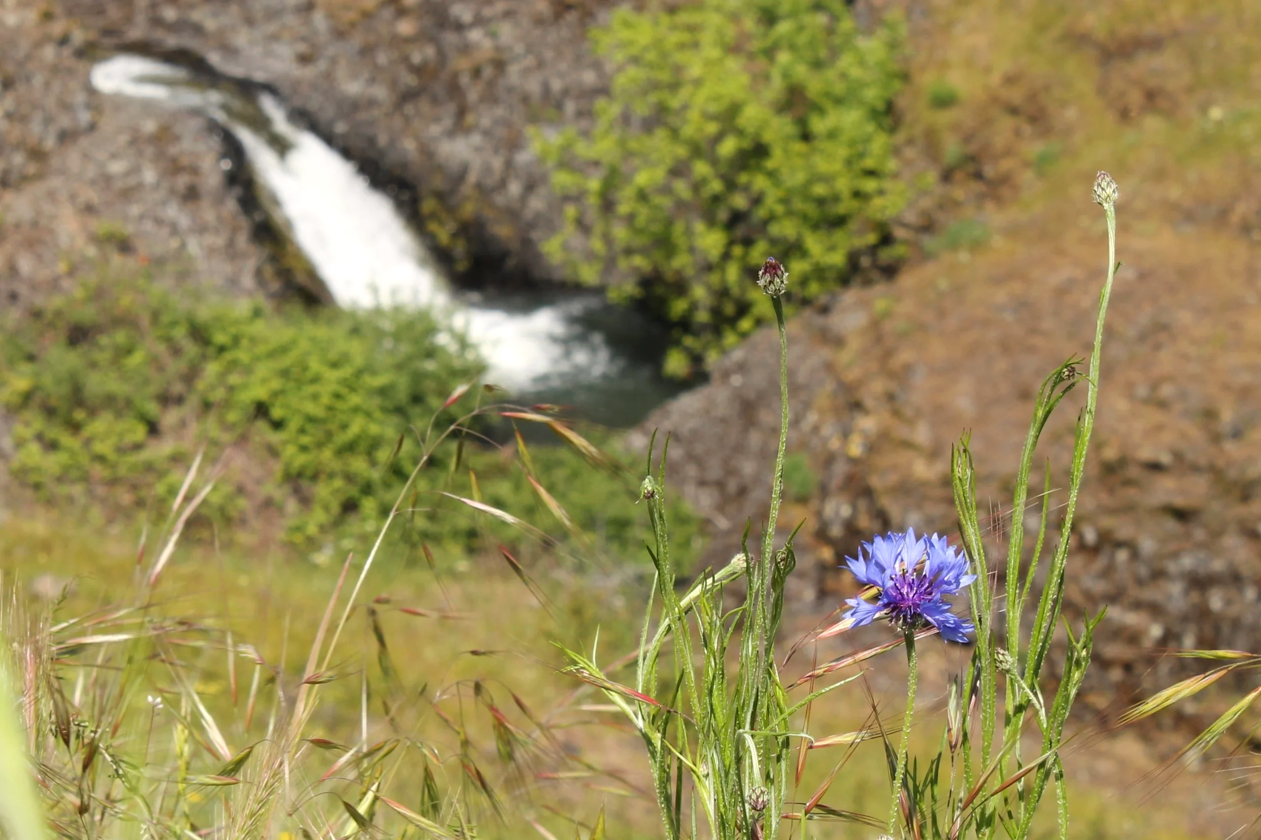
Bachelor button blooms near Catherine Creek Falls
Hiking: 1.2-mile loop
Difficulty: Easy
Pass required: None
ADA access: The Catherine Creek Universal Access Trail is 4 feet wide and paved. It doesn’t have barriers like steps. The grade is up to 12%. The trail has benches.
Drive time from Portland: 75 minutes (with bridge toll) or 95 minutes (via Hwy 14)
The waterfall: At 15 feet tall, Catherine Creek Falls looks more like a larger cascade along Catherine Creek than a waterfall. As part of a greater whole, it’s a lovely addition to a meadow where wildflowers bloom in spring.
How to see it: Catherine Creek Falls is one of the highlights of the Catherine Creek Universal Access Loop, one of the most inclusive trails in the Columbia Gorge. This easy and rewarding hike has excellent views of the Columbia River. Watch for rattlesnakes.
Learn more and see more hiking options in my guide to Catherine Creek.
22. Nick Eaton Falls
Herman Creek Trail
Hiking: 4.2+ miles out and back
Difficulty: Moderate
Pass required: Northwest Forest Pass or America the Beautiful Pass
ADA access: No
Drive time from Portland: 50 minutes
The waterfall: Nick Eaton Falls is a thin and wispy 90-foot waterfall. It’s a satisfying turnaround point for a low-key hike on the otherwise quite long Herman Creek Trail. In the winter, I also remember seeing a seasonal waterfall or two on the way there.
How to see it: Follow the Herman Creek Trail for just over two miles, and you can’t miss Nick Eaton Falls. It falls more or less onto the trail.
23. Labyrinth Creek waterfalls
Lower Labyrinth Falls
Hiking: 0.5+ miles
Difficulty: Easy to moderate
Pass required: None
ADA access: No
Drive time from Portland: 75 minutes
The waterfalls: Coyote Wall isn’t known for waterfalls, but the trail network has a couple of small ones along Labyrinth Creek. Lower Labyrinth Falls is a manmade waterfall that splashes down Coyote Wall itself. It’s a thin curtain in spring that I suspect might dry up in late summer. Labyrinth Falls is a pretty, 40-foot waterfall along the Labyrinth Trail. The brush around it makes it hard to get a great view from the trail.
How to see it: I probably wouldn’t go to Coyote Wall just for the waterfalls. The dramatic rock walls, panoramic Columbia River views, spring wildflowers, and mountain peak sightings are the stars here. The waterfalls are a cool bonus on the 6.5-mile Coyote Wall - Labyrinth Loop. Watch for rattlesnakes.
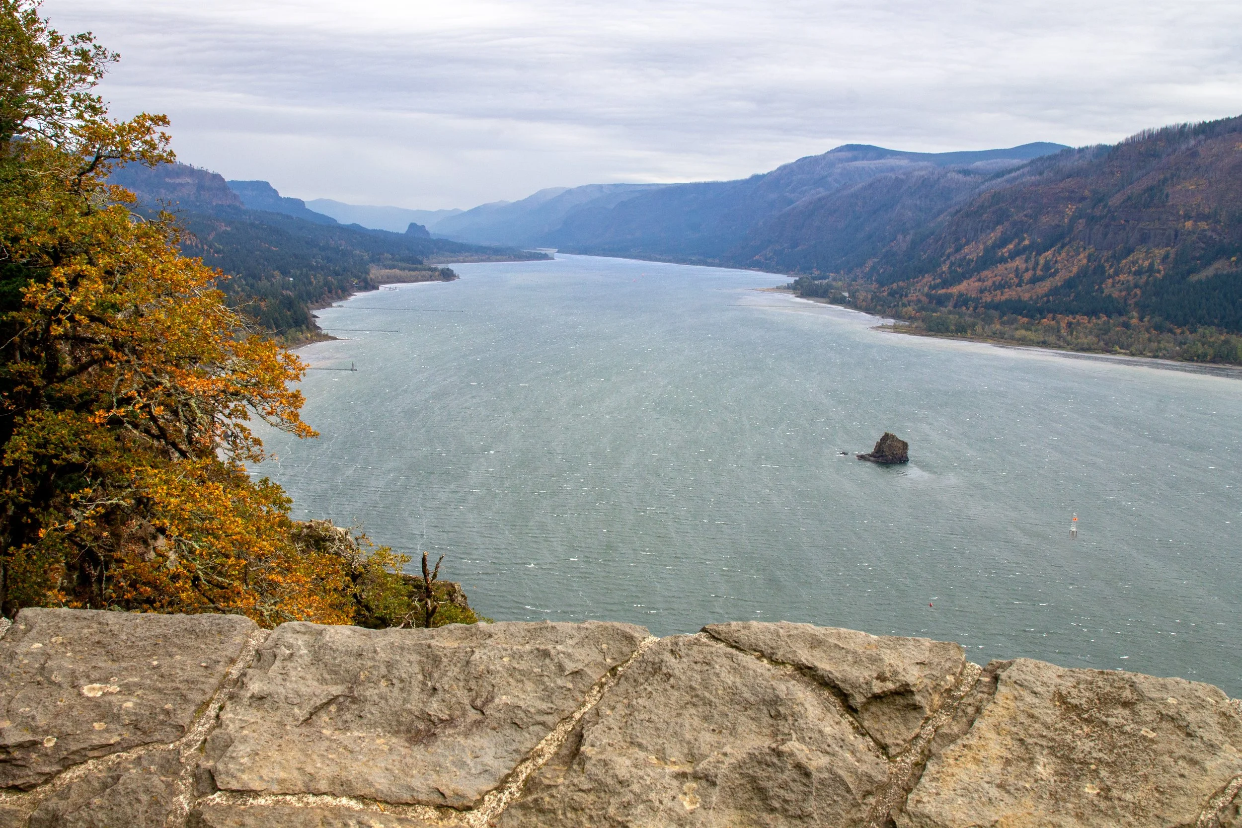
24. Cape Horn Falls
Cape Horn Falls (lower viewpoint)
Hiking: 7.2-mile loop (or 0.5-mile shortcut version)
Difficulty: Moderate
Pass required: None
ADA access: No
Season: Best when the loop hike is open from July 16th to January 31st.
Drive time from Portland: 40 minutes
The waterfall: Cape Horn Falls is my vote for the most disappointing waterfall in the Columbia Gorge. At 600 feet tall, it sounds like it will be awesome. When you get there, it’s underwhelming. I’ve seen more water falling out of the average shower head. In summer, it can dry up entirely. It also trickles down the cliff in such a way that you can’t see much of it at once. It’s on a cool hiking trail, so it’s still worth visiting for the Columbia Gorge views.
How to see it: The Cape Horn Trail has two viewpoints for Cape Horn Falls, one toward the top and the other at the bottom of the falls. The viewpoint at the top is open all year. The bottom of the falls is on a portion of the trail that closes from February 1st to July 15th to protect nesting peregrine falcons.
If you’d rather skip the 7.2-mile loop hike, there’s a shortcut to the Cape Horn Falls Viewpoint (top of the falls) from the Lower Cape Horn Falls trailhead parking area next to Highway 14.
Learn more about hiking the Cape Horn Trail.
Cape Horn Trail
Waterfall viewpoints and day hikes in the Columbia Gorge, a summary:
Multnomah Falls
Latourell Falls (and Upper Latourell Falls)
Hardy Falls, Rodney Falls, and Pool of the Winds
Wahclella Falls
Bridal Veil Falls
Horsetail Falls (and Ponytail Falls)
Eagle Creek waterfalls
Elowah Falls and Upper McCord Creek Falls
Wahkeena Falls
Wiesendanger Falls and friends
Starvation Creek Falls and friends
Triple Falls
Shepperd’s Dell Falls
Emerald Falls and Gorton Creek Falls
Dry Creek Falls
Fairy Falls
Coopey Falls (and Upper Coopey Falls)
Mosier Creek Falls
Oneonta Creek waterfalls
Dog Creek Falls
Catherine Creek Falls
Nick Eaton Falls
Labyrinth Creek waterfalls
Cape Horn Falls
Enjoy the waterfalls of the Columbia Gorge!
With love,
Emma
More waterfall hikes

Find the best waterfalls in the Washington Columbia Gorge. This list is a little different because I include some that are a little out of the way, like the Lewis River waterfalls.

Find the best waterfall hikes near Portland.
