

20 Best Hikes on the Oregon Coast
I really tried to keep this list at a nice, tight top ten. I couldn’t do it. Making it shorter meant leaving off too many incredible places. I did winnow down my original top 30 list, ruthlessly eliminating hikes without ocean views and some that were more like beach walks than trails. The hikes range from short and easy to long-ish and tiring. The scenery ranges from beautiful to mind-blowing. I live in Portland and visit the ocean as often as I can. I’ve been up and down the length of the coast and love exploring the trails. Here are the best hikes on the Oregon Coast.
Quick suggestions
I listed the hikes from north to south, figuring that suggestions within 2-3 hours of Portland are more useful than the ones 6 hours away. First, here’s the TLDR version for quick inspiration.
Best famous hikes
Cascade Head (#9)
The Knoll and the Thumb (#10)
Captain Cook Trail (#13)
Best obscure hikes
Rockaway Big Tree Trail (#5)
Sisters Rock (#18)
Indian Sands (#20)
Best barrier-free hikes for accessibility
Rockaway Big Tree Trail (#5)
Cape Meares (#6)
Shore Acres (#16)
Dogs: All the hikes on the list allow dogs, except for a couple. Unless I mention it, leashed dogs are welcome on the trail.
1. Clatsop Loop Trail
Distance: 3-mile loop
Elevation gain: 800 feet
Difficulty: Moderate
Family-friendly: Yes
Pass required: Oregon State Park Pass ($10/day)
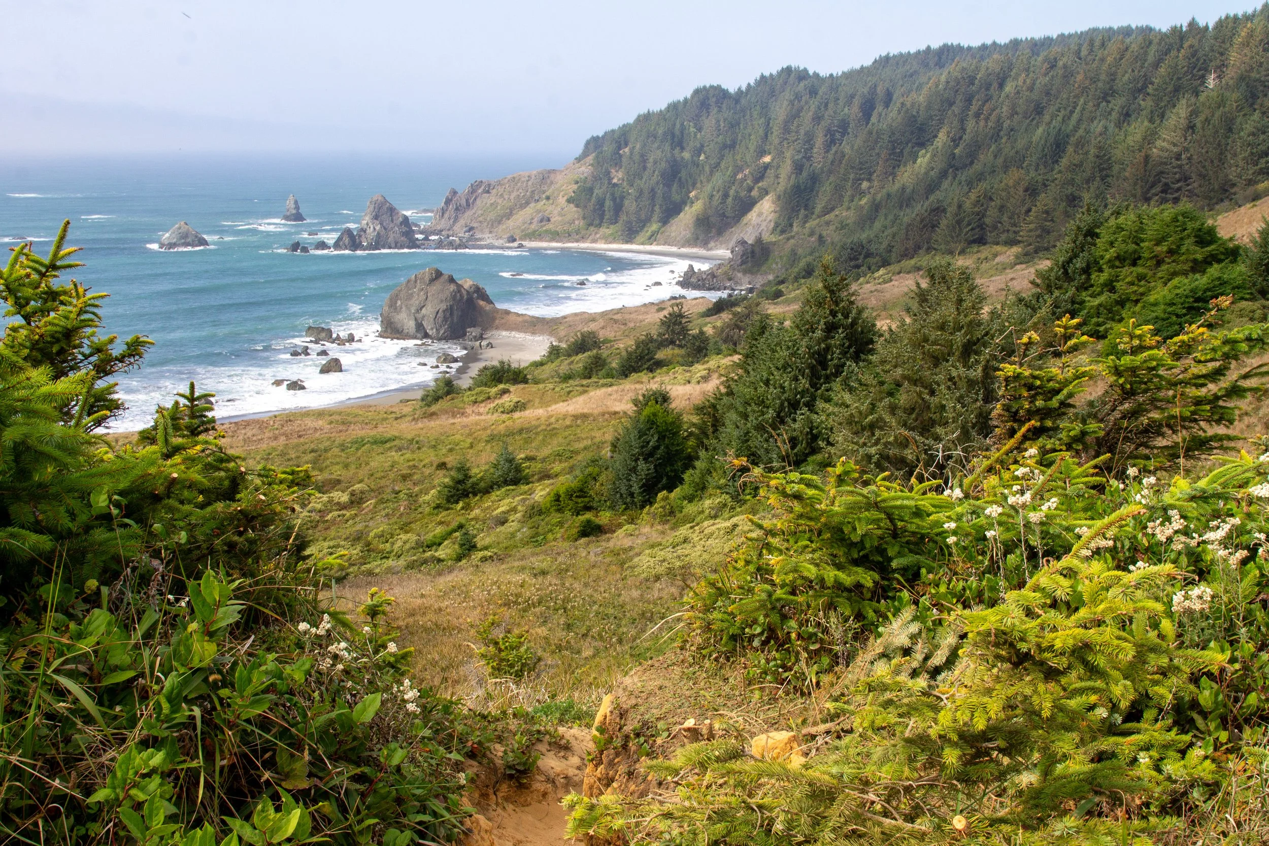
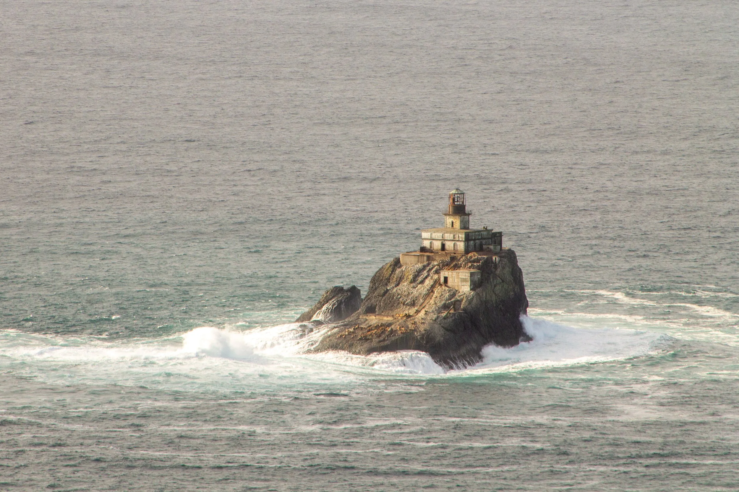
Ecola State Park has several fantastic hiking trails. I’m highlighting the Clatsop Loop Trail for its Goldilocks qualities. It’s less confusing and has easier terrain than the Crescent Beach Trail. It brings you to places you can’t reach by car, unlike the Indian Beach Trail. It’s long enough to feel like a workout without being an all-day commitment like the Tillamook Head Traverse Trail.
The hike begins at Indian Beach, one of the most picturesque on the Oregon Coast. From here, you head into a forest of sword ferns and moss-covered Sitka spruce trees. On the far end of the loop is a hiker’s camp, an old WWII radar station, and a viewpoint overlooking Terrible Tilly, Oregon’s infamous offshore lighthouse. The return journey has regular ocean views on the way back to Indian Beach. After your hike, picnic tables overlooking the beach are perfect for a snack break.
2. Short Sand Beach
Distance: 1.2 miles out and back
Elevation gain: 100 feet
Difficulty: Easy
Family-friendly: Yes, it’s one of the best on the list for kids.
Pass required: Oregon State Park Pass ($10/day)
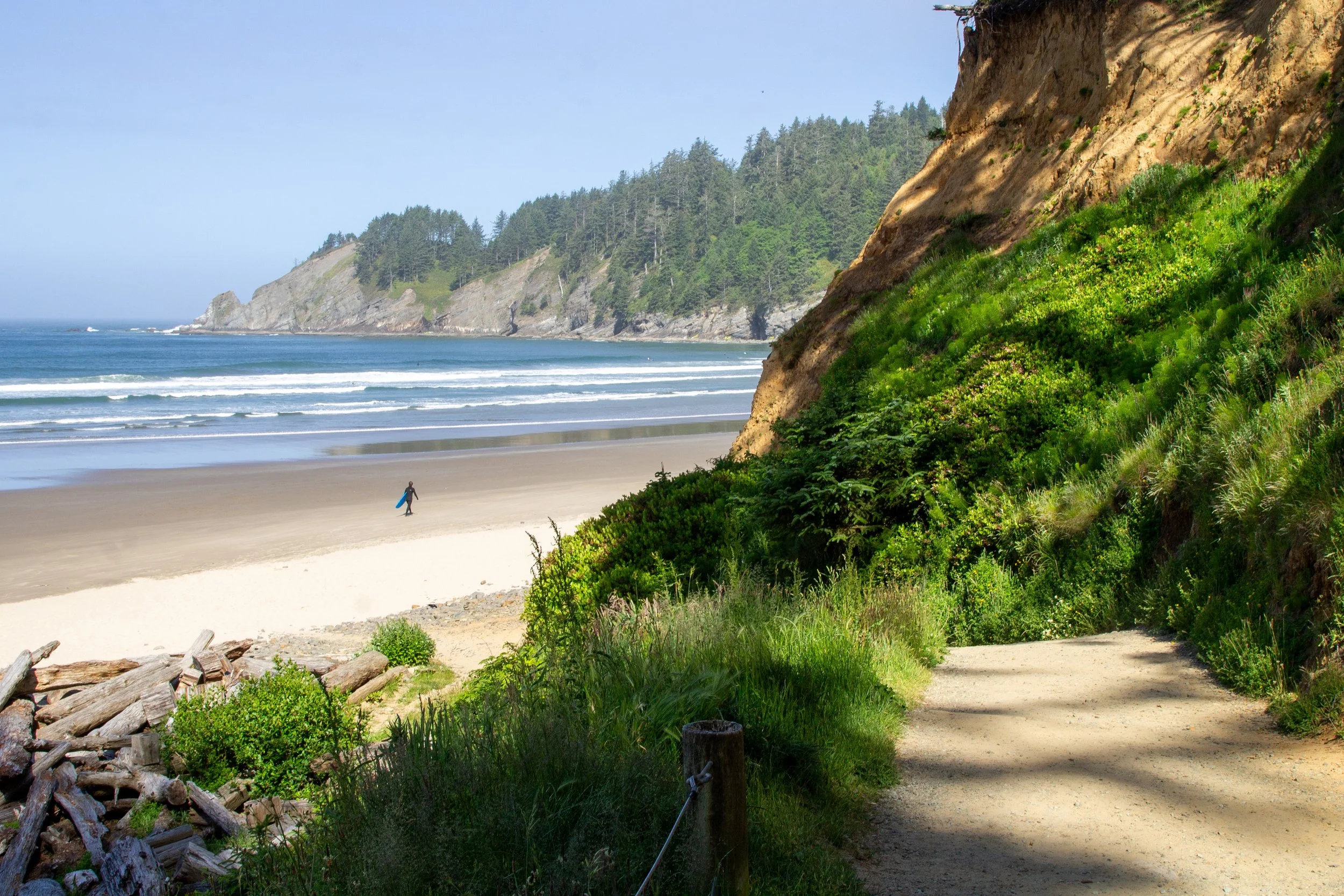
If it’s your first time visiting the Oregon Coast, Short Sand Beach is a great destination. Despite being only 10-15 minutes from two popular beach towns, Cannon Beach and Manzanita, it feels wild and remote. The beach sits in a protected notch between Cape Falcon and Neahkahnie Mountain. No buildings or roads intrude on the old-growth forest covering the hills that surround the beach. Although it looks like a secret world, it’s a very well-loved place that gets crowded. I’d suggest arriving by 10 AM to get a parking spot. The trail follows Short Sand Creek past some massive trees and impressive nurse stumps. Once you’re on the beach, you’ll see Blumenthal Falls tumbling down the cliffs of Cape Falcon. Look for tidepools around the waterfall at low tide.
Longer hike option: Short Sand Beach is an easy side trip along the Cape Falcon Trail. This 5-mile hike brings you to fantastic views of Neahkahnie Mountain from the end of the cape. The terrain is notably harder than the Short Sand Beach Trail. Unless you hike later in the summer, prepare for an absurd amount of mud.
3. Elk Flats Trail
Distance: 1 mile in two out-and-back trails
Elevation gain: 200 feet
Difficulty: Easy
Family-friendly: Only the Devils Cauldron Viewpoint (trail to the right). Avoid the Neahkahnie cliffs viewpoint (trail to the left).
Pass required: None
Most people visiting the Oregon Coast drive by the Elk Flats Trailhead without realizing it’s there. The parking area is a boring-looking gravel patch next to Highway 101. Once you park, head for the gap in the blackberry bramble. A small sign will reassure you that you’re on the Elk Flats Trail and not some fool’s errand. The trail splits in two right away, each direction leading to a spectacular viewpoint. Heading to the right, you walk through a meadow on the way to Devils Cauldron, where waves enter a narrow channel and crash against a towering cliff. This viewpoint has a fence for safety. The other direction leads to the unfenced viewpoint overlooking the thick basalt columns of the Neahkahnie cliffs. If you do both, it’s about a mile.
Longer hike options:
The Elk Flats Trail continues past Devils Cauldron to Short Sand Beach, about 3 miles out and back. It enters the forest and gets rougher past the Devils Cauldron viewpoint.
Another trail starts across the highway from the Elk Flats Trailhead. It’s the longer way to hike up Neahkahnie Mountain, via the north face. Details below.
4. Neahkahnie Mountain
Distance: 3 or 5 miles out and back
Elevation gain: 900 or 1,200 feet
Difficulty: Moderate
Family-friendly: Yes, with older kids.
Pass required: None
The summit of Neahkahnie Mountain is the highest-elevation overlook on the Oregon Coast that’s within easy driving distance of Portland. Two trails lead to the top, one on the north face and the other on the south. Although both are unrelentingly uphill, they’re less intense than you’d expect from a trek up a mountain. No matter which route you take, the views from the summit are unforgettable, at least when it’s not foggy. Looking south, you see Manzanita and Nehalem Bay from 1,600 feet.
The Neahkahnie Mountain South Trail is the shortest and easiest version of the hike, 3 miles out and back. Look for the trailhead at the end of Neahkahnie Mountain Rd.
The Neahkahnie Mountain North Trail starts across Highway 101 from the Elk Flats Trailhead. It’s longer and harder than the south approach, closer to 5 miles round-trip. It’s also more open, meaning better views on the way up.
For a challenge, an 8-mile loop hike connects Short Sand Beach, Devils Cauldron, and Neahkahnie Mountain. The downside is that you’ll need to walk about a mile next to Highway 101 to finish the loop. It’s reasonably safe, just unpleasant. You’ll need an Oregon State Park Pass to park in the Oswald West lot.
5. Rockaway Big Tree Trail

Distance: 1.2 miles out-and-back (boardwalk) or loop (rougher)
Elevation gain: Minimal
Difficulty: Easy
Family-friendly: Yes, including strollers.
Pass required: None
The Rockaway Big Tree Trail is the only hike on the list without ocean views. I added it for two reasons. The first is the finale, a viewing platform around a 154-foot western red cedar. The Big Tree is about 1,000 years old. It’s survived hurricanes, tsunamis, logging, and countless winter storms. The gnarled trunk reflects its age, marked by numerous knobs and burls. The canopy is home to many birds, which are easier to hear than see from ground level. Besides the tree, what I love about the Big Tree Trail is that it welcomes everyone. The boardwalk trail has a flat and even surface from start to finish, a rarity on the Oregon Coast. It’s a place you can hike with a stroller or a wheelchair. You pass benches and a small picnic area as you stroll through a swampy coastal forest. After your hike, Rockaway Beach is only a few minutes away.
6. Cape Meares

Distance: 0.5 - 3 miles
Elevation gain: Minimal to 200 feet
Difficulty: Easy to moderate
Family-friendly: Yes
Pass required: Oregon State Park Pass ($10/day)
Cape Meares is perhaps more of a viewpoint stop than a hiking destination. I considered leaving it off the list, but the views are just too good. Plus, if you do all the trails, it’s about three miles. The two most impressive are the Cape Meares Lighthouse Loop and the Octopus Tree Trail. Both start from the main parking lot at the end of the road into the park.
Only 38 feet tall, the Cape Meares Lighthouse is Oregon’s shortest lighthouse. The 0.5-mile Lighthouse Loop Trail has spectacular ocean views almost from start to finish. In summer, wild roses poke through the fences around the trail.
The 0.3-mile Octopus Tree Trail leads to one of the Oregon Coast’s most bizarre sights, a Sitka spruce tree lacking a central trunk. Instead, giant limbs radiate out like octopus tentacles. Just beyond the tree is a whiz-bang viewpoint overlooking Short Beach, Oceanside, and Cape Lookout.
Most people stop here, but Cape Meares has more to see if you like finding hidden corners. The other trails start from the dirt parking area near the park entrance.
The Big Spruce Trail is an easy 0.3-mile hike to another excellent tree. This one is normal-shaped, just huge. The 800-year-old Sitka spruce is the largest of its kind in Oregon.
The Cape Meares Trail is the biggest commitment, about 2 miles out and back with a lot of uphill walking on the return trip. The payoff is a seldom-visited beach with great wildlife-watching potential.
7. Cape Lookout
Distance: 5 miles out and back
Elevation gain: 900 feet
Difficulty: Moderate
Family-friendly: Yes, for the first mile. After that, the trail has difficult terrain and gets close to drop-offs.
Pass required: None
The Cape Lookout Trail isn’t going to be everybody’s cup of tea. It’s a place where you’ll see a lot more people at the beginning of the hike than at the end. If you’re with your non-hiking friends and trying to sell them on the concept, I’d go somewhere else. One of the quirks of the trail is that the first mile is much easier than the rest. It begins with a relaxing walk through a beautiful coastal forest. As you spot the wildflowers in the undergrowth and admire occasional glimpses of the ocean, you’ll be thinking how smart you were to come here. Then, things change. The last mile and a half is a swampy mess of tree roots and mud puddles for most of the year. If you squelch your way to the end, the views from Cape Lookout are fantastic. Keep an eye out for whales below you. Since the cape sticks out so far into the ocean, whales sometimes come very close to it as they swim past.
Longer hiking option: After tackling the Cape Lookout Trail, you can take the South Trail down to the beach on the south side of the cape. It would add around 3.5 miles and a good deal of uphill walking, but you’ll have a good chance of solitude on the beach.
8. Cape Kiwanda
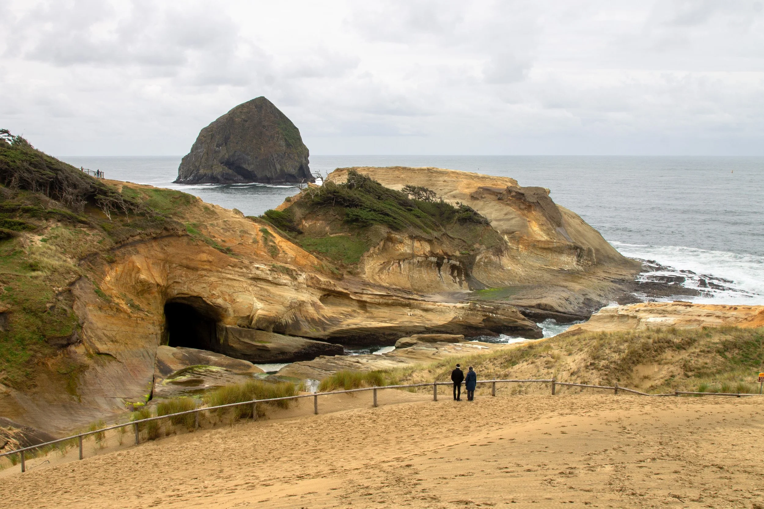
Distance: 1 mile out and back
Elevation gain: 200 feet
Difficulty: Easy
Family-friendly: Yes, if you stay behind the fences.
Pass required: $10 local parking fee
Safety note: Stay behind the fences on Cape Kiwanda. People have died in unsafe areas beyond them.
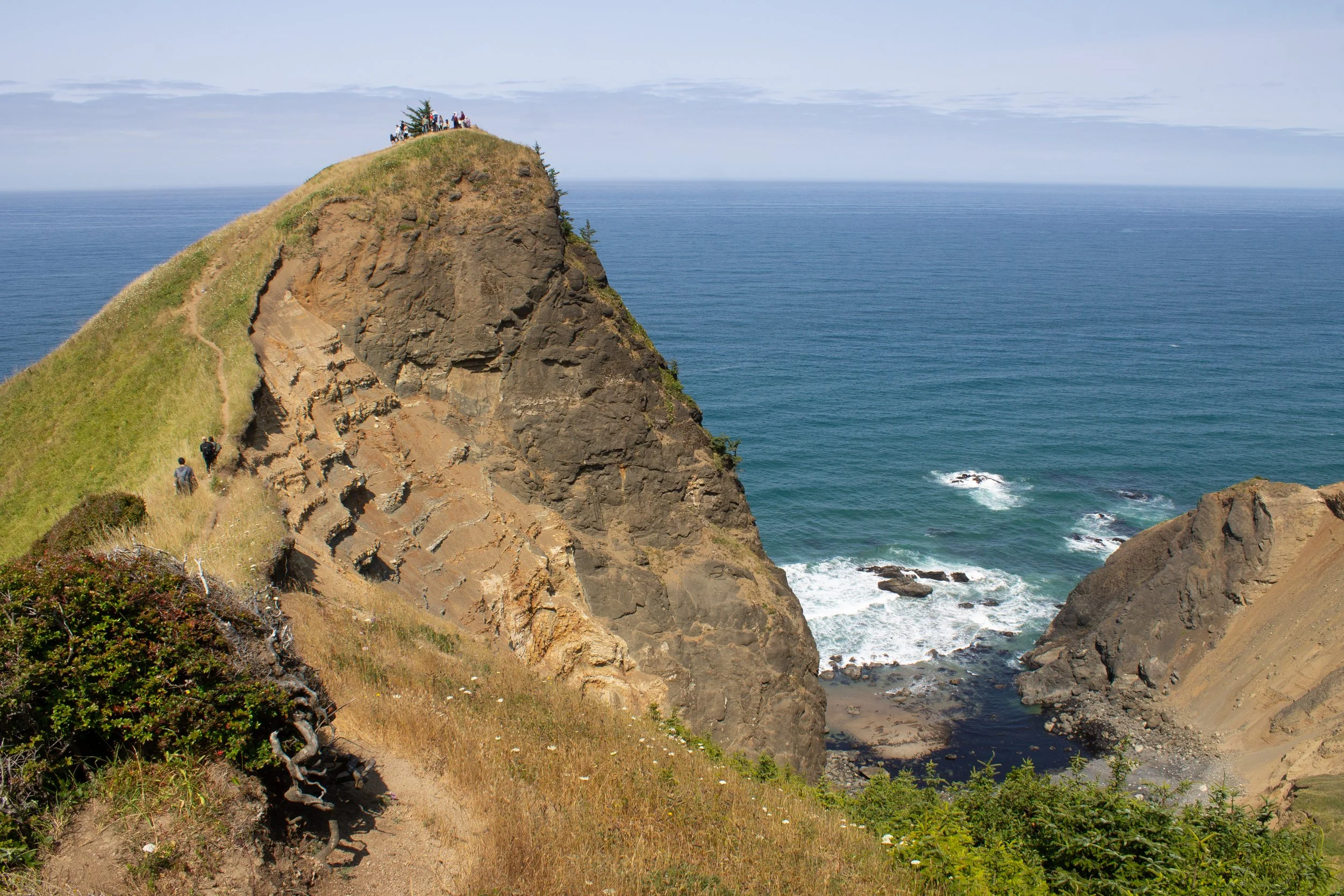
Cape Kiwanda is an anomaly on the Oregon Coast. Long after other sandstone headlands crumbled into sandy beaches, it’s still looming large over Pacific City. Geologists attribute the cape’s longevity to the protection it receives from Haystack Rock, the eye-catching monolith about a mile offshore. A short hike will bring you from the beach to a series of viewpoints on top of the cape. It’s more of a walk up a dune than a traditional trail. While the distance is short, the payoffs are huge. Waves undercut the rock of the cape, forming sea caves, arches, and the newest feature, a large and growing sinkhole. Cape Kiwanda’s torturous cliffs are the perfect foreground for the 180-degree ocean panorama. If you visit at low tide, look for excellent tidepools on the south side of the cape after your hike.
9. Cascade Head

Distance: 4.5 miles out and back
Elevation gain: 1,200 feet
Difficulty: Moderate
Family-friendly: Yes. Better for older kids because of uphill walking.
Pass required: None
Conservation note: Dogs are not allowed on Cascade Head. Please stay on the trail. Don’t pick any flowers or remove anything.
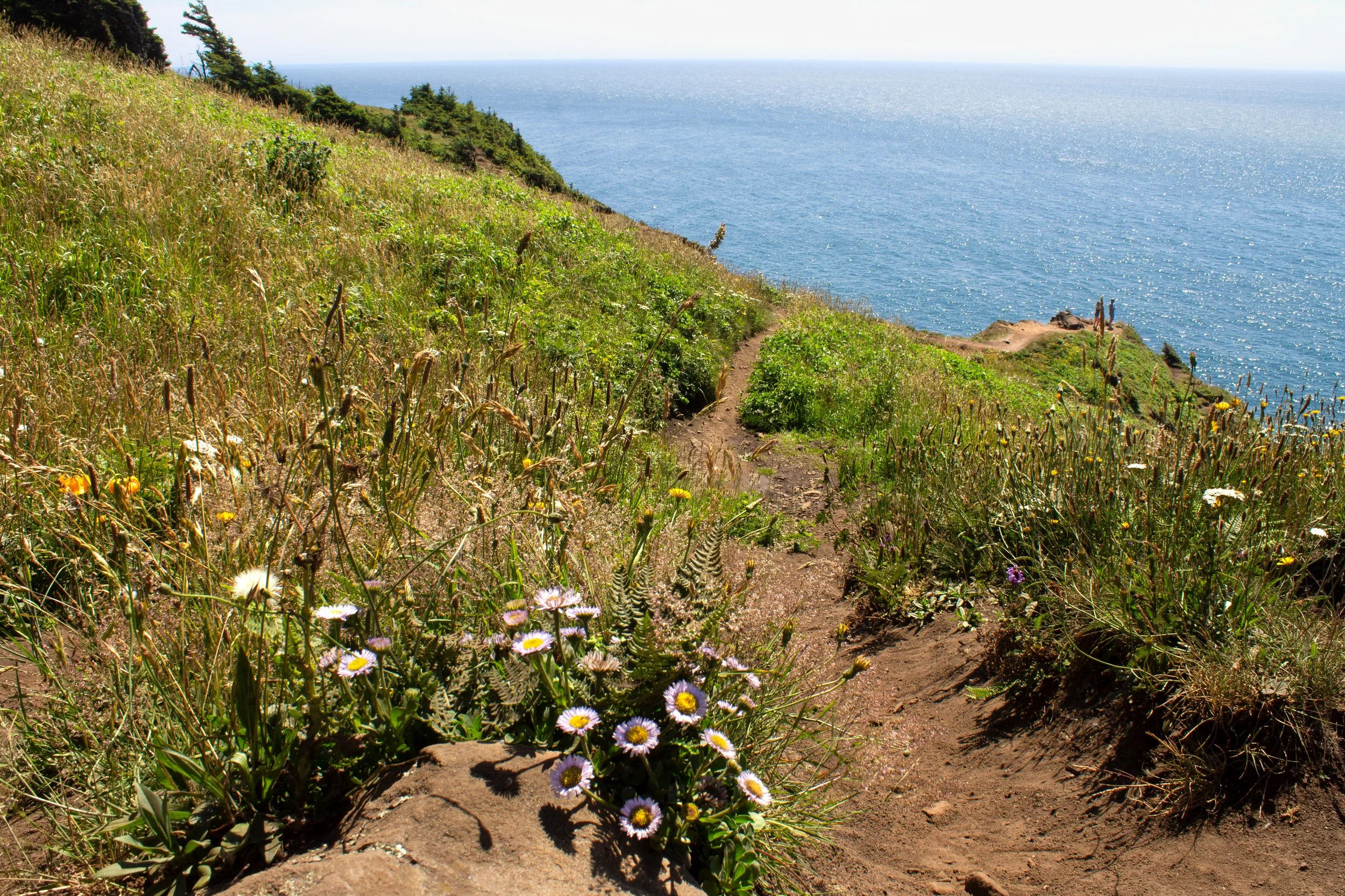
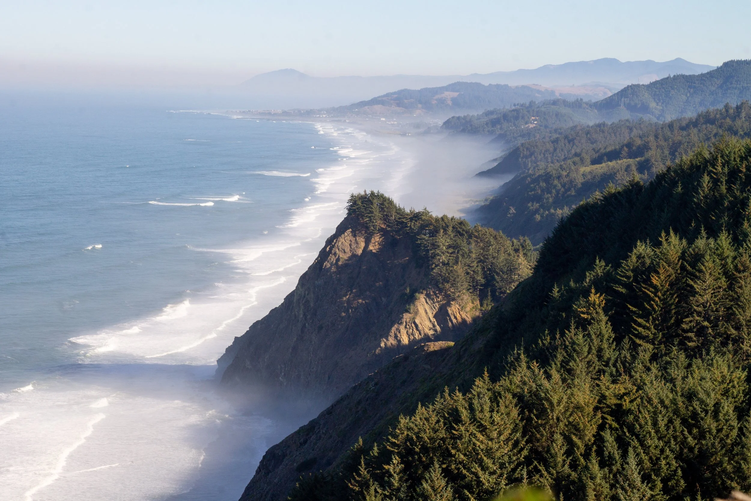
The Cascade Head Trail explores one of the most unique and sensitive habitats on the Oregon Coast. Native grass prairies cover the headland rather than Sitka spruce forests. The area has a long history of controlled burns, a practice that the Nechesney Indians began. Today, the Nature Conservancy continues it. Throw in a southern exposure and a drier microclimate, and you get tons of wildflowers, including some little princesses that struggle to grow anywhere else. Always follow the Leave No Trace principles when you’re hiking. Definitely, definitely follow them here.
Wildflower season or no, this hike is extraordinary. Views from Cascade Head are not quite like anywhere else on the Oregon Coast. The Salmon River estuary stretches out beneath you as you make your way uphill. Looking south past the long, U-shaped spit is a breathtaking stretch of coastline from Lincoln City to Boiler Bay. Foggy days can be disappointing. The first time I came, I trudged up the hill only to have a marine layer roll in, blocking any hint of the ocean.
Longer hike options: The Lower Cascade Head Trail I described above is open all year. If you visit from July 16th to December 31st, you can continue on the Upper Trail, about 6 miles out and back. Beyond the Upper Trailhead, a difficult trek on an unmaintained trail brings you to a viewpoint overlooking the waterfall at Hart’s Cove, around 14 miles in total.
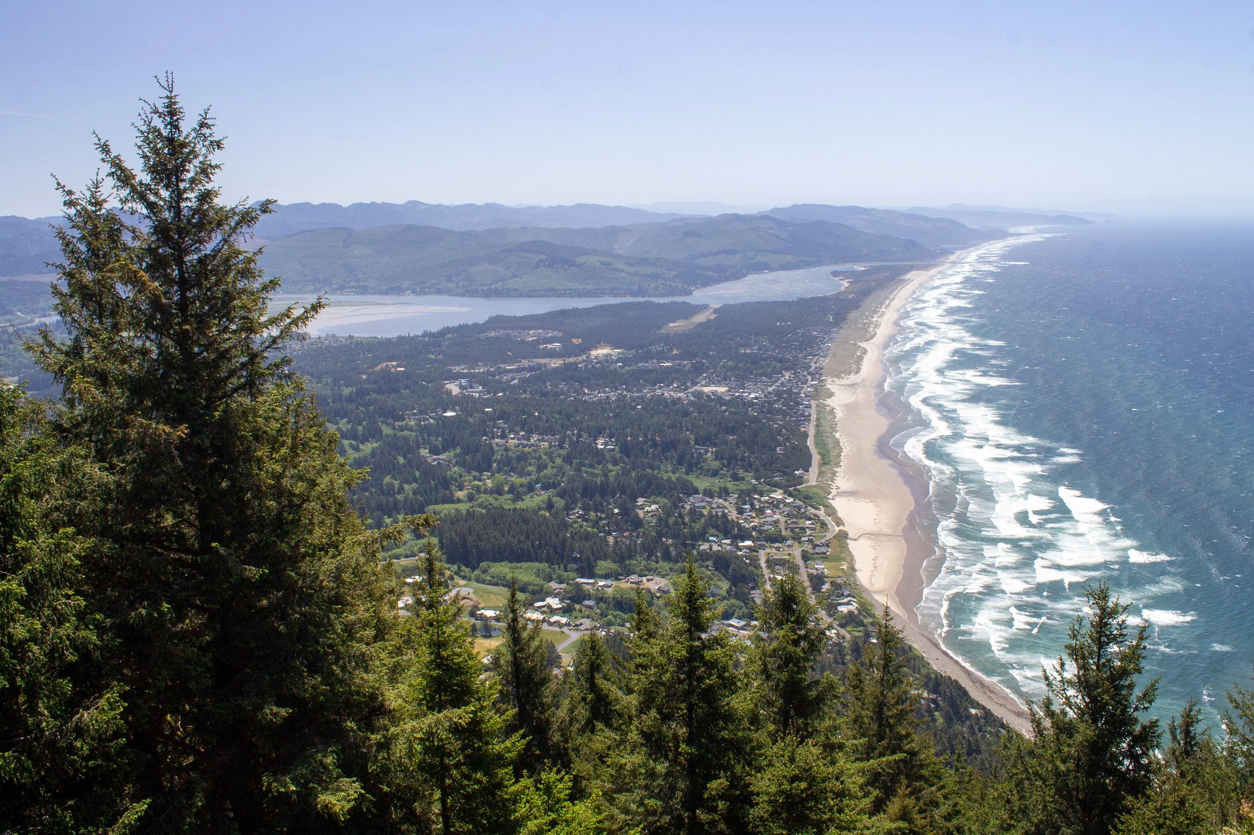
10. The Knoll and the Thumb
Distance: 3-mile loop (the Knoll) or 4.8-mile loop with spur (to the Thumb)
Elevation gain: 650 or 1,100 feet
Difficulty: Moderate
Family-friendly: Only to the Knoll, NOT to the Thumb.
Pass required: None
Safety note: The Thumb is an unofficial hike with an area of unsafe trail conditions. Don’t hike here with small children. People bring dogs, but I wouldn’t recommend it.
Lincoln City’s most famous hike has two versions. One is the official and uncontroversial trail to the Knoll. This hike is a wonderful, family-friendly 3-mile loop through the woods that ends at a stunning meadow overlooking Lincoln City. My favorite times to visit are late spring and summer when wildflowers bloom on the hillside. As you make your way around the loop, you’ll reach a spur trail that leads out to the Thumb, also called God’s Thumb, which requires a bunch of disclaimers.
The Thumb was obscure until it blew up on social media around 10-ish years ago. Today, it’s one of the most popular hikes on the Oregon Coast and draws a lot of people from out of town. The trail has two main problems. One is that it’s close to private land and poorly marked, so hikers sometimes accidentally trespass. The second is that the end of the trail passes next to a crumbling cliffside. To be fair, the views at the end are excellent, similar to those from the Knoll but farther-reaching. If you tackle this one, approach it with caution and use the spur trail from the Knoll hike rather than climbing up from Road’s End beach.
Learn more about the Knoll and the Thumb.
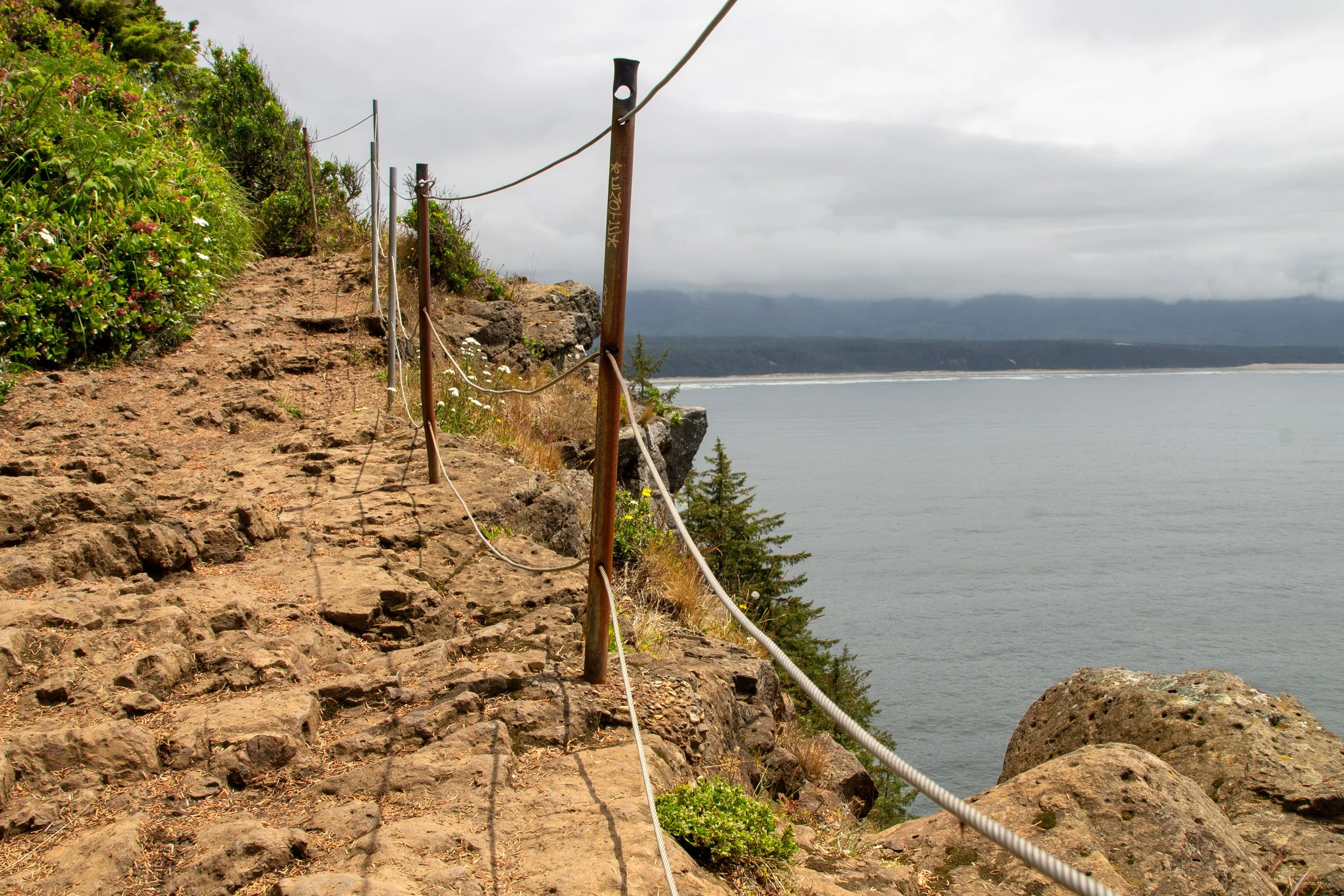
11. Devils Punchbowl
Distance: 1 mile out and back
Elevation gain: 100 feet
Difficulty: Easy
Family-friendly: No. I’d skip it with kids younger than 7.
Pass required: Oregon State Park Pass ($10/day)
Safety note: Do not attempt this hike unless the tide is very low and the ocean is calm.
The Devils Punchbowl is one of the most astounding sights on the Oregon Coast. It formed when the ceiling of a sea cave collapsed, leaving behind a gaping hole in the coastline. Waves enter through hidden channels and churn against cylindrical cliffs. At the lowest tides, they recede far enough to empty the Punchbowl.
Unlike most hikes on the Oregon Coast, entering the Devils Punchbowl requires careful timing to stay safe. When you look down into it from the parking lot viewpoint, you should see piles of boulders at the bottom without any ocean water entering. Arrive 30-60 minutes before low tide, which should be at or below zero, and on a day when the sea is calm. To reach the base of the Punchbowl, head to Otter Crest Beach and walk south from the beach access. Check out my detailed directions for specifics and photos.
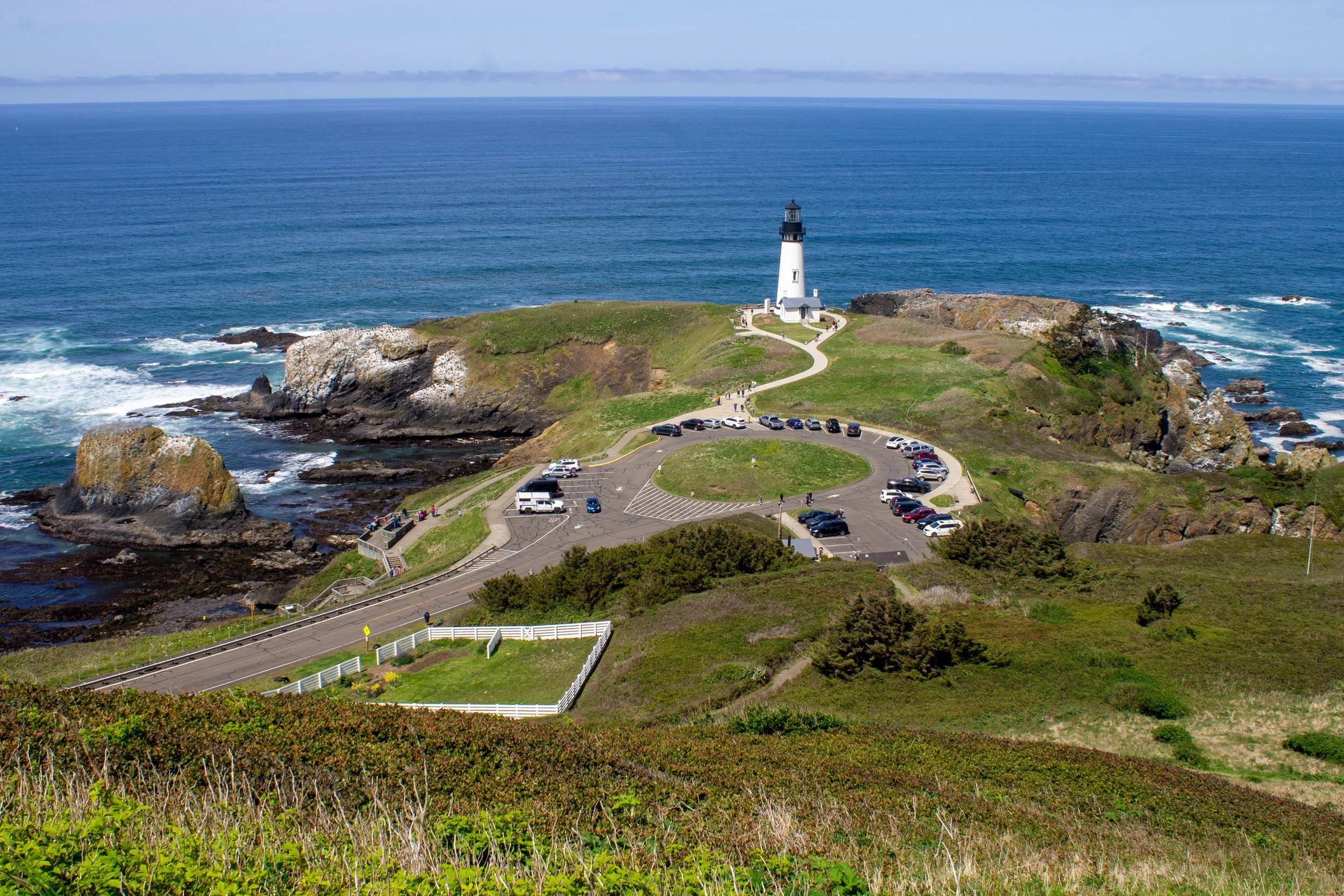
12. Yaquina Head
Distance: Up to 3.5 miles
Elevation gain: Up to about 300 feet
Difficulty: Easy
Family-friendly: Yes
Pass required: $7/vehicle or America the Beautiful Pass or Oregon Coast Passport
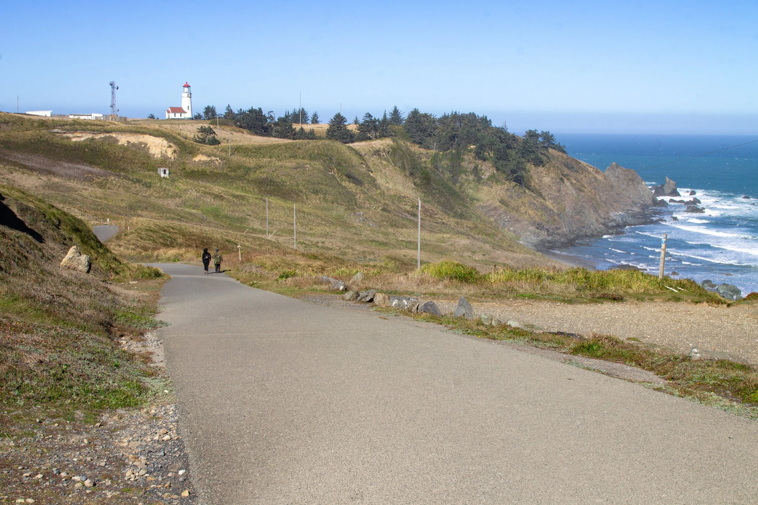
Whether or not you hike, Yaquina Head Outstanding Natural Area will knock your socks off. The centerpiece is Yaquina Head Lighthouse, the tallest in Oregon. It stands on cliffs above the Pacific at the end of a long peninsula. No trees or hills block the views, creating an almost 360-degree ocean panorama. I’ve seen sea birds and seals every time I’ve visited, and whales several times. From the lighthouse viewpoint, it’s a short walk to a staircase that leads down to Cobble Beach, arguably the best on the Oregon Coast for tidepools. The hiking trails are a bonus at Yaquina Head rather than the main event. Several short trails take you to less-visited corners of the park. If you do them all, it’s about 3.5 miles. My favorite is the Salal Hill Trail, a 0.7-mile hike that leads to magnificent overhead views of the lighthouse and the coastline.
13. Captain Cook Trail
Distance: 0.6+ miles
Elevation gain: 100+ feet
Difficulty: Easy to moderate
Family-friendly: No. Stick to the viewpoints that are farther back from the ocean.
Pass required: NW Forest Pass ($5/day), Oregon Coast Passport, or America the Beautiful Pass
Safety note: Keep a healthy distance from the ocean as you explore, especially during high tide. Be careful to step only on bare rock to avoid crushing any intertidal animals that live on the rocks.
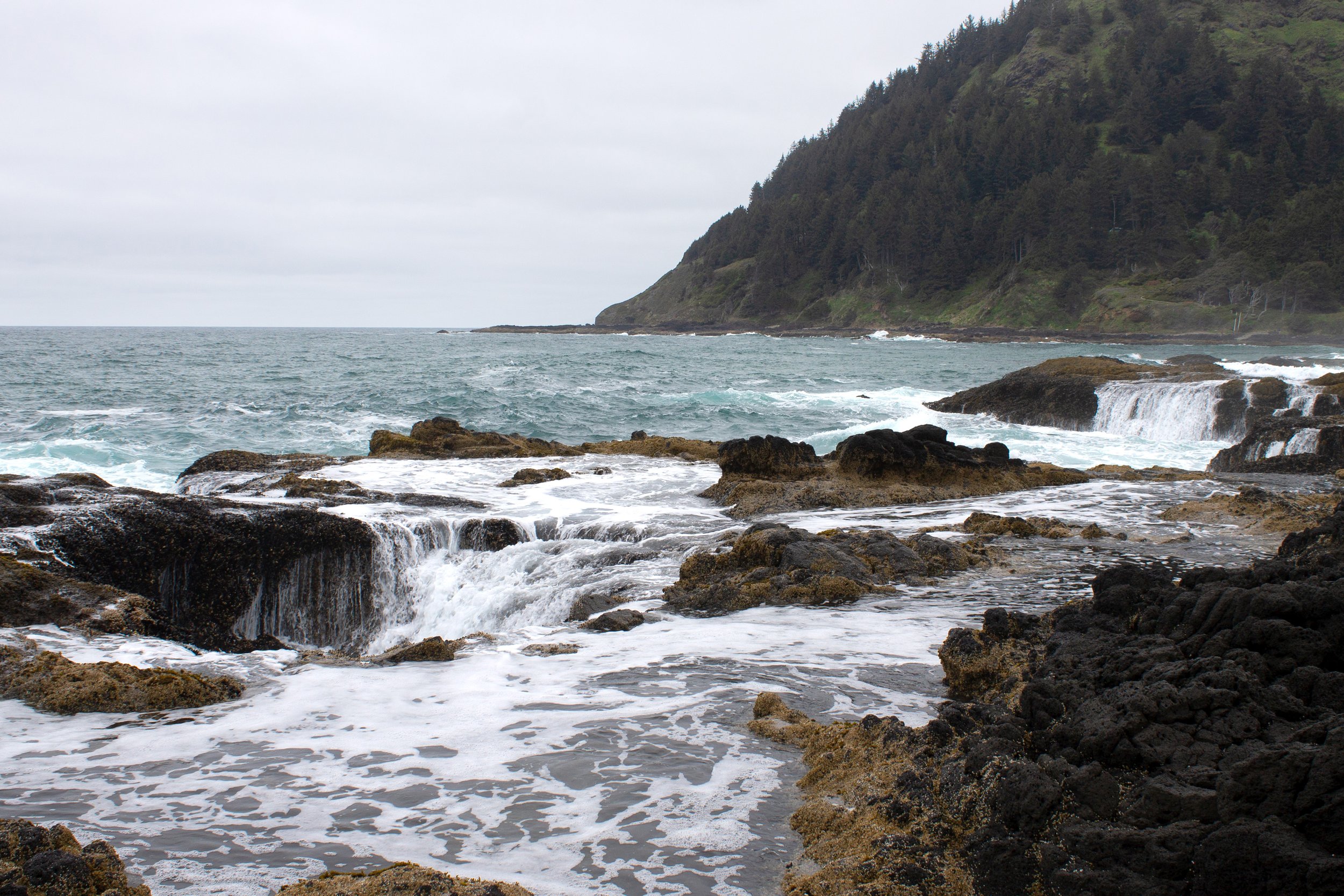
Cape Perpetua has many hiking trails. All are beautiful. A few will blow your mind. I’d say the top priority is the short and easy Captain Cook Trail. It’s only 0.6 miles from the parking area next to Highway 101 or 1 mile from the Visitor Center, but it brings you some of the most unforgettable geologic wonders on the Oregon Coast. Low tide is the best time to visit the tidepool area. High tide is when to see mist shooting out of Spouting Horn and ocean waves disappearing into Thor’s Well. Since the hike is short, you may want to check out one of the other excellent trails nearby.
The 2.6-mile Saint Perpetua Trail leads from the Visitor Center to an incredible viewpoint overlooking Cape Perpetua from 800 feet. You can also drive up to the top if you’d rather save your energy.
Amanda’s Trail is a 6-mile out-and-back hike leading from the town of Yachats to the Cape Perpetua Viewpoint.
Several inland hiking trails explore the old-growth forest around Cape Perpetua. They lack the wow factor of the ocean views, but are peaceful places to spend time with some very old trees. Check out the easy, 2-mile Giant Spruce Trail.
14. Heceta Head

Distance: 1 mile (Heceta Head Lighthouse) or 5 miles (Hobbit Beach) out and back
Elevation gain: 150 or 1,000 feet
Difficulty: Easy or Moderate
Family-friendly: Yes
Pass required: Oregon State Park Pass ($10/day)
Heceta Head Lighthouse is one of the most stunning sights on the Oregon Coast. The weathered red-and-white tower sits in front of steep, forested hills on the edge of 200-foot cliffs. You’ll park at the beach below the lighthouse. Behind you is the elegant arch of the Cape Creek Bridge. The creek that flows beneath the bridge is a popular spot for rockhounding.
To reach the lighthouse, look for the trail starting from the parking lot. It heads gently uphill for a half mile. You’ll pass the old keeper’s house, now a bed and breakfast, on the way to Heceta Head Lighthouse and a stunning viewpoint overlooking the coastline to the south. You can turn around here for an easy 1-mile hike, or continue to Hobbit Beach for a 5-mile round-trip journey. One of the most overlooked spots on the Oregon Coast, Hobbit Beach is named for its unique entrance, which looks like a hobbit tunnel.
15. John Dellenback Trail
Distance: 1-mile or 5-mile loop
Elevation gain: Up to 200 feet
Difficulty: Easy or hard
Family-friendly: Yes, the 1-mile version.
Pass required: NW Forest Pass ($5/day), America the Beautiful Pass, or Oregon Coast Passport
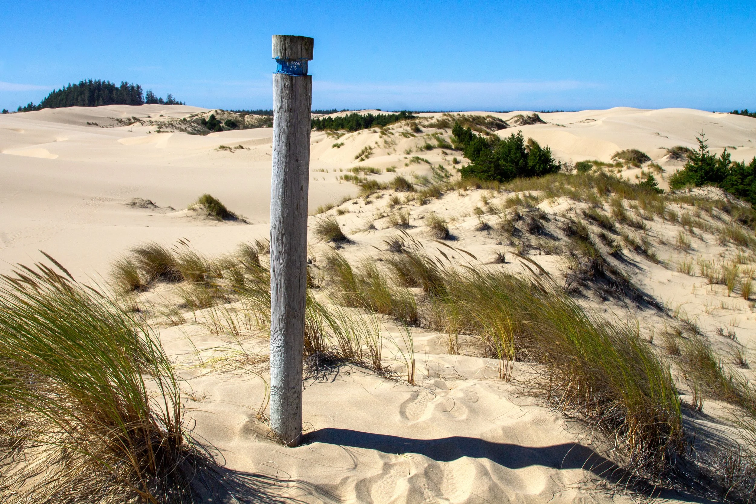
The John Dellenback Trail is one of the more unusual hikes on the Oregon Coast. Instead of forests or rocky headlands, it traverses a sea of dunes. The hike has an easy and a hard version. The easy version is a 1-mile loop that brings you to the start of the dune field and back. It’s a great place to stretch your legs on a road trip. The hard version crosses the dunes on the way to the ocean.
Before seeing the trail, I worried about losing my way in the dunes. Once I got there, I realized that posts mark the route at regular intervals. It’s still a good idea to have an offline map with you, but the stretch I did was easy to follow. Easy to follow, mind you, not easy to hike. Y’all, this trail is hard. Don’t let the approachable distance fool you. Walking on soft sand is different than other surfaces. The only thing that comes close is deep snow. I did a couple of miles, which was more than enough for my bum leg. The otherworldly scenery makes it worth some trudging. As you look out onto a sliver of blue beyond a vast expanse of sand, you’ll feel like you’ve reached the edge of the world.
16. Shore Acres

Distance: Many options from 0.5 miles up to 8 miles
Elevation gain: Minimal to 600 feet
Difficulty: Easy to moderate
Family-friendly: Yes, in sections.
Pass required: Oregon State Park Pass ($10/day)
Note: Dogs are not allowed outside of the car at Shore Acres. Head to Sunset Bay or Cape Arago State Park instead if you’re traveling with a dog.
The Cape Arago Scenic Highway connects three stunning state parks near Coos Bay: Sunset Bay, Shore Acres, and Cape Arago. If you follow the hiking trails from one end to the other, it’s about 8 miles out and back. To narrow our focus, I’ll talk about the trails around Shore Acres, which I like for several reasons. First is the botanical garden, which is a beautiful place to stroll before seeking out the ocean views. After visiting the garden, look for the paved hiking trail along the coastline. Follow the 1.4-mile Cape Arago Loop for a short hike that will take you to some of the weirdest-looking cliffs on the Oregon Coast. Back at the parking lot, a short and sweet 0.6-mile trail leads down to Simpson Cove.
17. Cape Blanco
Distance: 0.6+ miles out and back
Elevation gain: 100 feet
Difficulty: Easy
Family-friendly: Yes, the Lighthouse Trail.
Pass required: Oregon State Park Pass ($10/day)
The park map in Cape Blanco State Park shows many hiking trails. I’ve found them to be a bit hit and miss. One I searched for seemed to have been reclaimed by nature. Another had become a swamp during seasonal flooding. Other trails are fantastic, if weather-dependent. The main attraction is the short hike to the Cape Blanco Lighthouse. After driving almost to the end of the cape, you park by the gate and walk the last 0.3 miles. Long, pristine beaches stretch out on either side of you as you make your way to Oregon’s westernmost point. The downside is the wind, which can be intense. Oh, and rain and fog. If the weather isn’t dreadful, it’s worth layering up to see the views. To tackle a longer hike, I’d suggest heading down to one of the beaches. The one to the north is just down the hill from the parking gate. The hike to the south beach stays on top of the cliffs before descending to the beach near the campground, about 2 miles out and back.
18. Sisters Rock

Distance: 1 mile out and back
Elevation gain: 200 feet
Difficulty: Easy
Family-friendly: Mostly. Be careful around the sea cave and watch for waves when near the shoreline.
Pass required: None
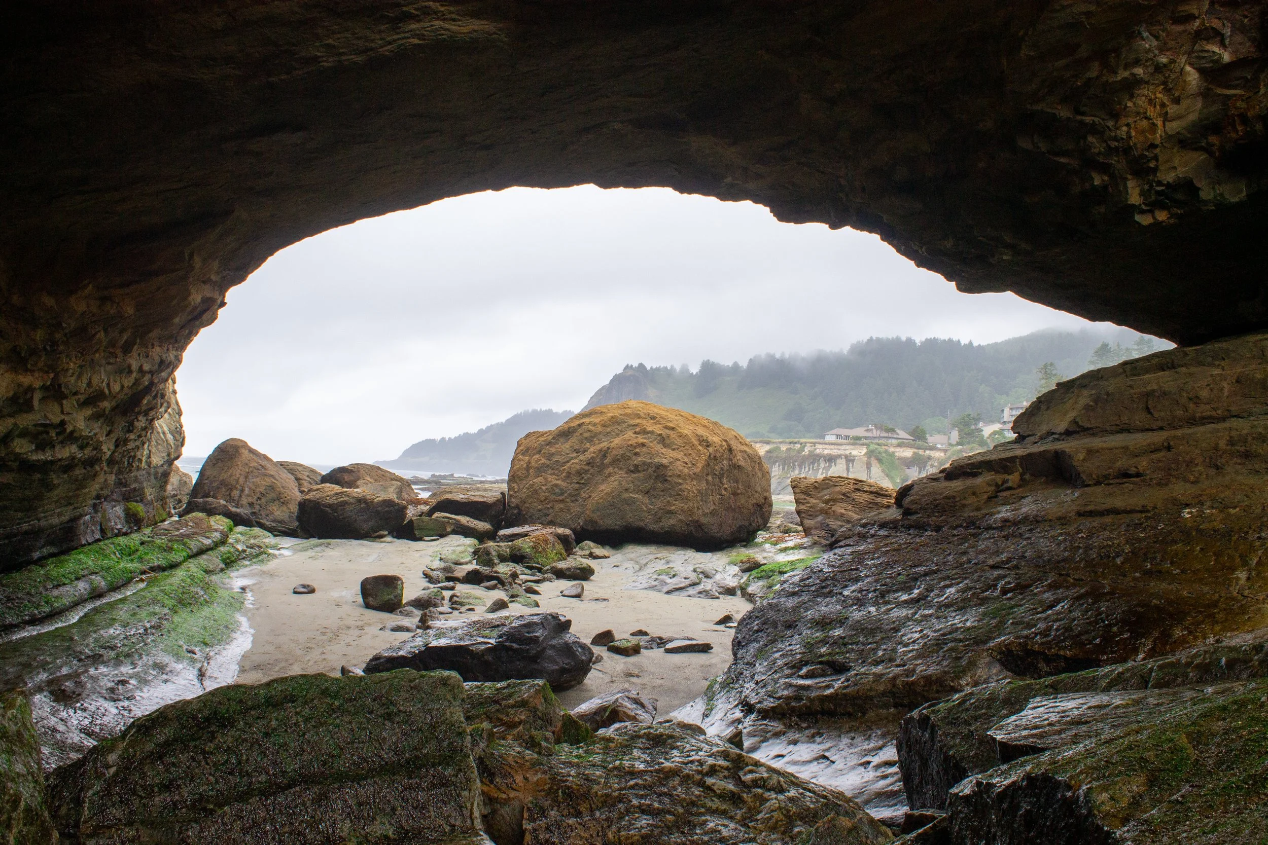
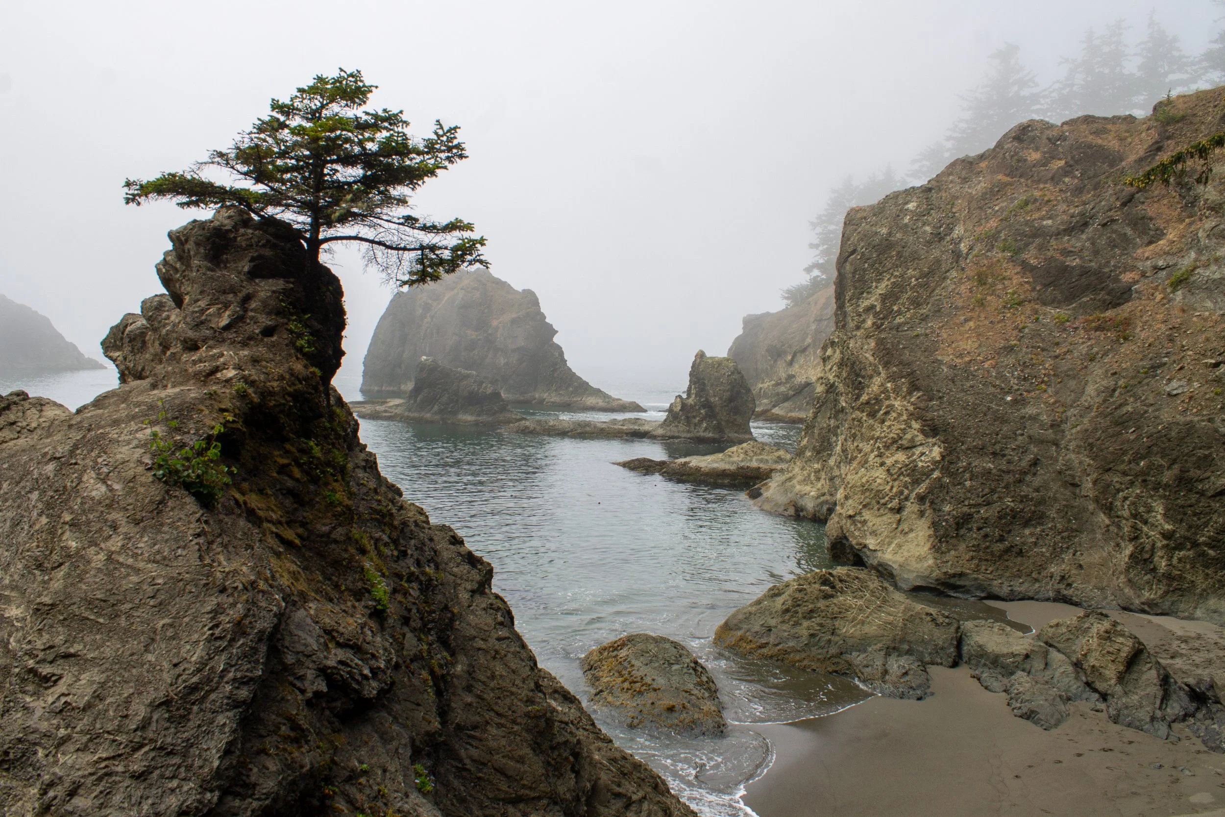
Sisters Rock State Park is a winning combination of breathtakingly beautiful and extremely obscure. A solid 5 hours from Portland, this stretch of the Oregon Coast gets a paltry number of visitors compared with areas farther north. Most of those who do come drive right past the three peaks of Sisters Rock without more than a “huh, look at those things out there.” If you make the short hike to the end of the peninsula, you’ll get big rewards for a small amount of effort. The trail ends at the base of the Sisters. Inside the largest peak is a huge sea cave where waves enter through channels in the rock. You can turn around at the sea cave for a quick road trip stop, or make it a longer hike by walking along one of the beaches next to Sisters Rock. Frankport Beach on the south side has some weird old artifacts left over from a time when a shipping dock stood here.
19. Natural Bridges and Secret Beach
Distance: 1.5 miles out and back
Elevation gain: 400 feet
Difficulty: Moderate
Family-friendly: Yes, to the Natural Bridges Viewpoint. The Secret Beach Trail is better for older kids. The descent to the beach requires a scramble.
Pass required: None
Safety note: I’ve seen a lot of hikers, both in person and on social media, on top of Natural Bridges. This dangerous area is beyond the official trail. Please don’t be that person. Besides the risk to your safety (people have died here), you put rescuers in danger if you run into trouble.
Tides: Secret Beach is only accessible at low to medium tides. You can still have a look at it from above at high tide, but you won’t be able to walk on the beach.
If your only exposure to the Oregon Coast was Instagram, you’d think 90% of it was either Secret Beach or Natural Bridges. These photogenic places are next to each other in the Samuel Boardman Corridor, a remote part of the southern Oregon Coast. Natural Bridges is easier to find. A sign points to the parking lot from Highway 101. From here, a 0.3-mile hike brings you to a fenced viewpoint overlooking Natural Bridges from above. I’d recommend turning around here. The trail continues downhill, but doesn’t lead to better views. Again, please don’t continue to the unsafe areas beyond where the trail ends.
Instead, head to the parking immediately north of Natural Bridges and take the trail to Secret Beach. After a final scramble to the beach, you’ll see a small waterfall tumbling onto the sand. A handful of domed rock islands stand just offshore this hidden cove. It’s a great place to look for wildlife, especially seals and seabirds. You’ll see some excellent tidepools at low tide. The trail to the beach can be confusing. Check out my detailed directions.
For a unique way of exploring Secret Beach, try a kayak tour.
20. Indian Sands
Distance: 1.1-mile loop
Elevation gain: 300 feet
Difficulty: Moderate
Family-friendly: No
Pass required: None
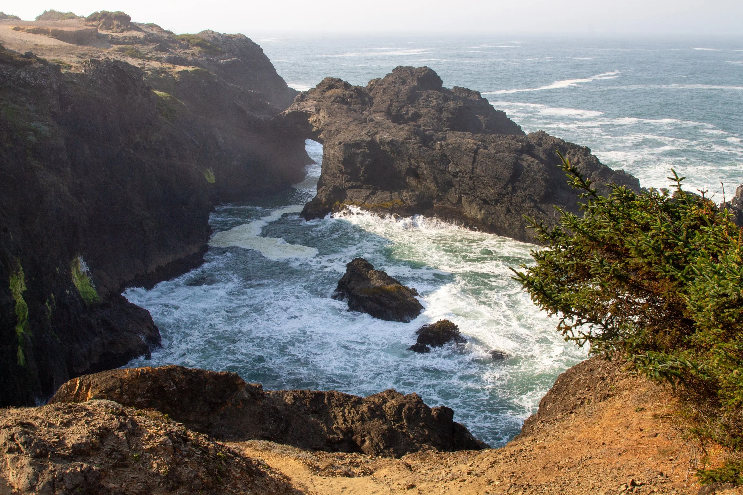
Indian Sands is one of the most stunning and least visited places on the Oregon Coast. I came with no expectations and left feeling almost dizzy from the beauty of the place. For being so photogenic, it keeps a surprisingly low profile. The handful of pictures you’ll find online, including mine, don’t come close to doing it justice. The loop trail explores dunes and rugged cliffs. One memorable sea arch rises from the ocean like a serpent. A few notes of caution. The trail is close to unfenced cliffs that drop down to jagged rocks and crashing waves. Stay on the trail and keep dogs on leash. It’s not a good hike with younger kids. The trail is on sand, making it harder to follow and more tiring than the short distance suggests. Have an offline map and bring water.

Best hikes on the Oregon Coast, summary:
Clatsop Loop Trail
Short Sand Beach
Elk Flats Trail
Neahkahnie Mountain
Rockaway Big Tree Trail
Cape Meares
Cape Lookout
Cape Kiwanda
Cascade Head
The Knoll and the Thumb
Devils Punchbowl
Yaquina Head
Captain Cook Trail
Heceta Head
John Dellenback Trail
Shore Acres
Cape Blanco
Sisters Rock
Natural Bridges and Secret Beach
Indian Sands Loop
Enjoy your hike on the Oregon Coast!
With love,
Emma
Honorable Mentions
One of the few obscure hikes within an easy drive from Portland, the trails through Sitka Sedge bring you from a tidal estuary to a beach near Pacific City.
Check out the lightly-trafficked Cape Sebastian Trail to Hunter’s Cove. It’s awesome. I didn’t put it on the list only because the southern Oregon Coast was taking over.

If Secret Beach feels too well-known, follow the confusing trail to China Beach. I can just about guarantee you’ll have it to yourself.